Download
Preview
Add to list
More
15.9 km
~4 hrs 25 min
743 m
Loop
“Explore the enchanting Bavarian Forest on the Mittagstein Loop, blending natural beauty with historical intrigue.”
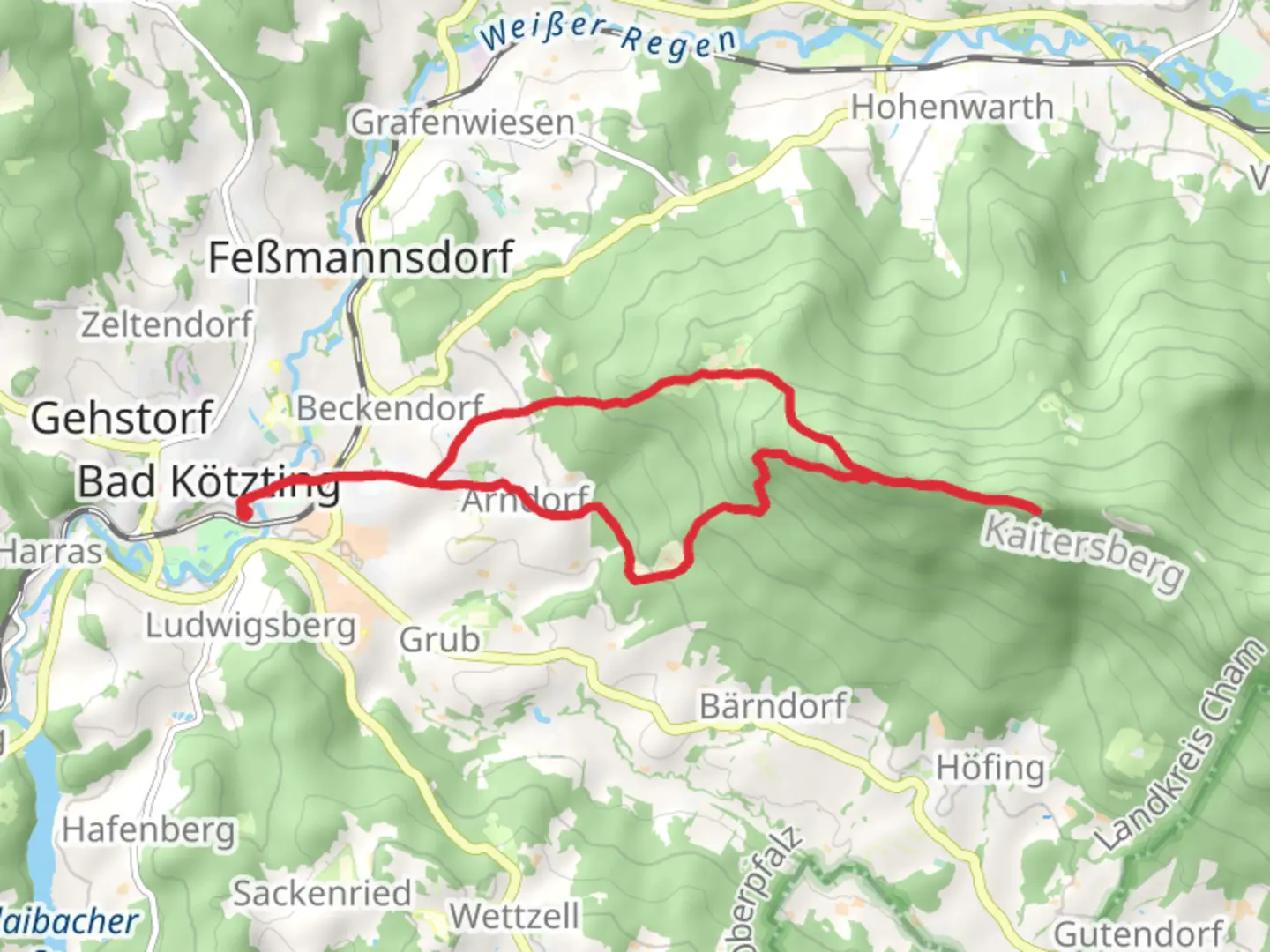
Nestled in the picturesque Bavarian Forest, the Mittagstein Loop via Zellertal offers a captivating journey through lush landscapes and historical sites. This 16 km (approximately 10 miles) loop trail, with an elevation gain of around 700 meters (about 2,300 feet), is a medium-difficulty hike that promises both challenge and reward. The trailhead is conveniently located near Cham, Germany, making it accessible for both locals and visitors.### Getting ThereFor those traveling by car, Cham is well-connected via the A3 and A93 highways. From Cham, follow the signs towards Zellertal, where ample parking is available near the trailhead. If you prefer public transport, Cham is accessible by train from major cities like Munich and Regensburg. From Cham's train station, local buses or taxis can take you to the trailhead.### Trail Highlights#### Scenic Views and Natural BeautyAs you embark on the Mittagstein Loop, prepare to be enveloped by the serene beauty of the Bavarian Forest. The trail meanders through dense woodlands, offering a rich tapestry of flora and fauna. Keep an eye out for native wildlife such as deer and various bird species that inhabit the area. The forest canopy provides a natural shelter, making this hike enjoyable even on warmer days.#### Mittagstein SummitApproximately halfway through the hike, you'll reach the Mittagstein summit, a notable highlight of the trail. At an elevation of 1,034 meters (3,392 feet), the summit offers panoramic views of the surrounding valleys and distant peaks. This is an ideal spot for a rest and a picnic, allowing you to soak in the breathtaking vistas.#### Historical SignificanceThe region around Cham is steeped in history, with remnants of ancient settlements and medieval structures. As you traverse the trail, you'll encounter historical markers and information boards detailing the area's past. The Zellertal valley itself has been a vital corridor for trade and travel since Roman times, adding a layer of historical intrigue to your hike.### Navigation and SafetyThe Mittagstein Loop is well-marked, but it's always wise to have a reliable navigation tool. HiiKER is recommended for its detailed maps and real-time updates. The trail is generally safe, but hikers should be prepared for uneven terrain and occasional steep sections. Sturdy hiking boots and trekking poles are advisable, especially after rain when the path can become slippery.### Flora and FaunaThe diverse ecosystem of the Bavarian Forest is a haven for nature enthusiasts. Depending on the season, you may encounter vibrant wildflowers, mushrooms, and a variety of tree species, including spruce and beech. The forest is also home to several protected species, so tread lightly and respect the natural habitat.### Final StretchAs you complete the loop, the descent offers a gentle return to the trailhead, passing through open meadows and small streams. This section provides a peaceful conclusion to your hike, with opportunities to reflect on the day's adventure amidst the tranquil surroundings.Whether you're a seasoned hiker or a nature lover seeking a day of exploration, the Mittagstein Loop via Zellertal promises an enriching experience in one of Germany's most beautiful regions.

Comments and Reviews
User comments, reviews and discussions about the Mittagstein Loop via Zellertal, Germany.
average rating out of 5
0 rating(s)