Download
Preview
Add to list
More
8.3 km
~2 hrs 17 min
374 m
Loop
“Experience the perfect blend of nature, history, and moderate challenge on Bamberg's scenic 8 km loop trail.”
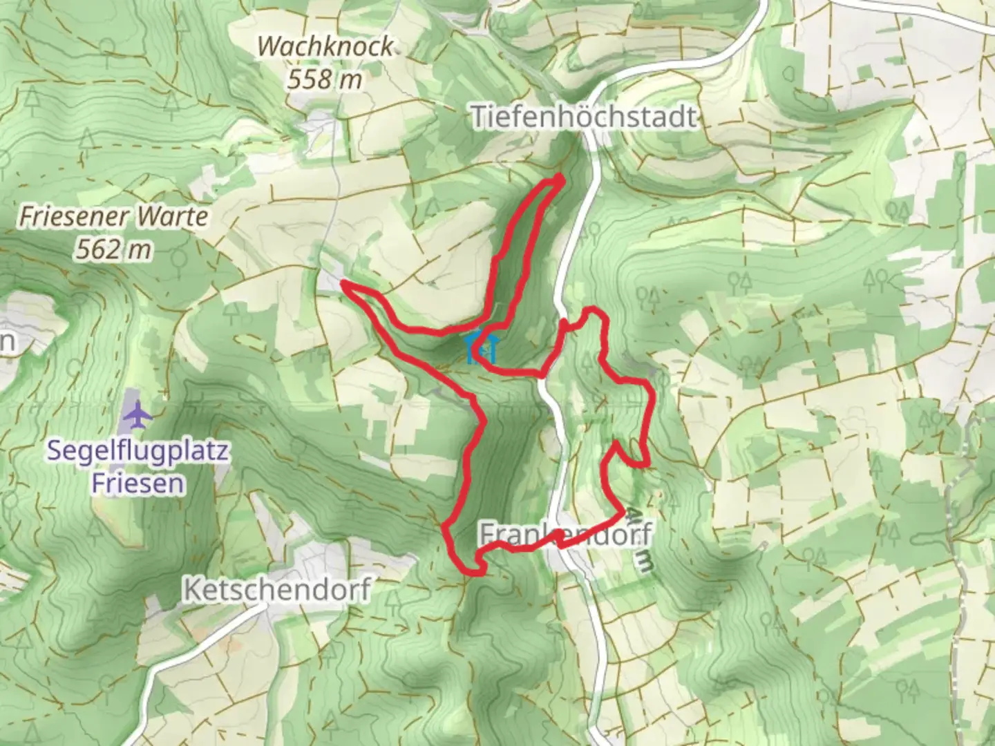
Starting near the picturesque town of Bamberg, Germany, the Dragonerspitz, Bergwachthutte, and Landrichterseite Loop is an 8 km (approximately 5 miles) trail with an elevation gain of around 300 meters (about 984 feet). This loop trail offers a medium difficulty rating, making it suitable for moderately experienced hikers.
Getting There
To reach the trailhead, you can either drive or use public transportation. If driving, head towards Bamberg and look for parking near the Altenburg Castle, a significant landmark in the area. For those using public transport, take a train to Bamberg Hauptbahnhof (Bamberg Central Station) and then a local bus to Altenburg Castle.
Trail Overview
The trail begins near Altenburg Castle, a medieval fortress that dates back to the 12th century. This castle offers a glimpse into the region's rich history and provides a scenic starting point for your hike. From here, the trail heads into the Franconian countryside, characterized by rolling hills, dense forests, and open meadows.
Key Sections and Landmarks
Dragonerspitz
The first significant landmark you'll encounter is Dragonerspitz, a hill that offers panoramic views of the surrounding landscape. The ascent to Dragonerspitz is gradual but steady, gaining about 150 meters (492 feet) in elevation over the first 2 km (1.2 miles). The summit provides a perfect spot for a short break and some photography.
Bergwachthutte
Continuing from Dragonerspitz, the trail descends slightly before climbing again towards Bergwachthutte. This section is about 3 km (1.8 miles) long and features a mix of forested paths and open fields. Bergwachthutte is a small hut used by local mountain rescue teams. While the hut itself is not open to the public, the area around it is ideal for a picnic. The elevation gain here is around 100 meters (328 feet).
Landrichterseite
The final significant section of the trail is Landrichterseite, a historical site that was once a judicial boundary in medieval times. This part of the trail is relatively flat and stretches for about 3 km (1.8 miles). The path meanders through dense forests, offering a serene and shaded environment. Keep an eye out for local wildlife, including deer and various bird species.
Navigation and Safety
Given the trail's moderate difficulty, it's advisable to use a reliable navigation tool like HiiKER to stay on track. The trail is well-marked, but having a digital map can be invaluable, especially in the forested sections where paths can be less distinct.
Flora and Fauna
The trail is rich in biodiversity. In spring and summer, you'll find a variety of wildflowers, including orchids and lilies. The forests are home to oak, beech, and pine trees. Wildlife sightings are common, so be prepared to encounter deer, foxes, and a variety of bird species.
Historical Significance
The region around Bamberg has a deep historical significance. Altenburg Castle itself has been a strategic military site for centuries. The Landrichterseite section of the trail offers a unique glimpse into the judicial history of medieval Germany, where local lords would settle disputes and administer justice.
Final Stretch
The loop concludes as you make your way back towards Altenburg Castle. The final 2 km (1.2 miles) are mostly downhill, providing a gentle end to your hike. This section offers more open views of the Franconian countryside, making it a pleasant way to finish your journey.
This trail offers a balanced mix of natural beauty, historical landmarks, and moderate physical challenge, making it a rewarding experience for any hiker.

What to expect?
Activity types
Comments and Reviews
User comments, reviews and discussions about the Dragonerspitz, Bergwachthutte and Landrichterseite Loop, Germany.
4.6
average rating out of 5
5 rating(s)