Download
Preview
Add to list
More
12.4 km
~3 hrs 6 min
381 m
Point-to-Point
“Explore the enchanting 12 km trail from Amberg-Sulzbach, blending natural beauty, historical intrigue, and moderate challenge.”
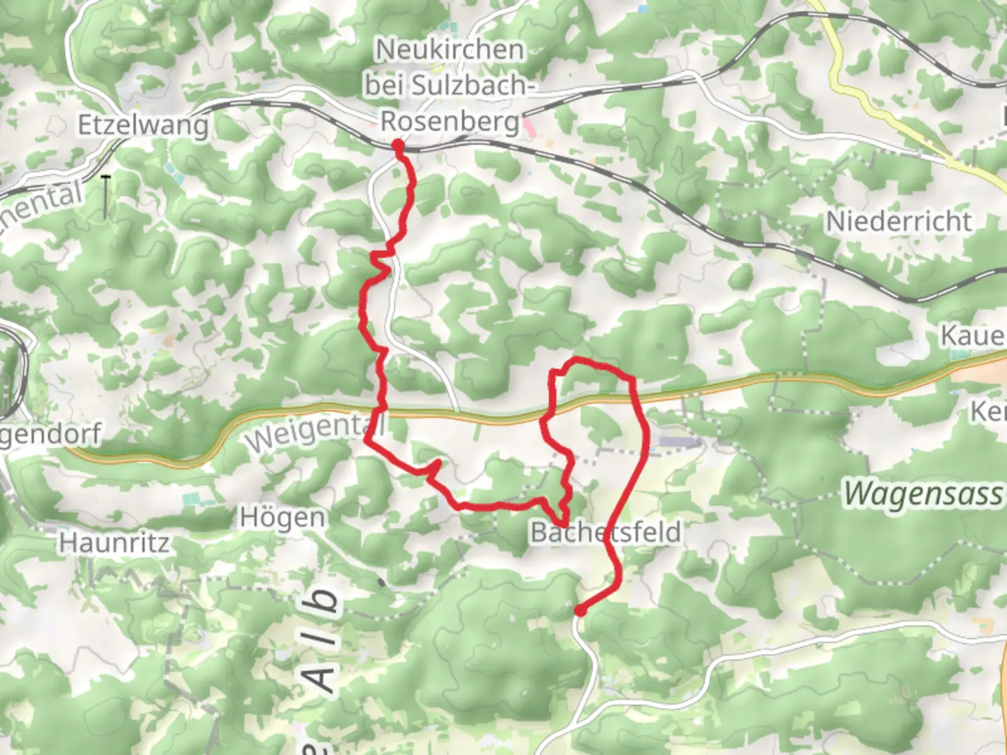
Starting near the picturesque town of Amberg-Sulzbach in Germany, this 12 km (approximately 7.5 miles) point-to-point trail offers a delightful mix of natural beauty and historical intrigue. With an elevation gain of around 300 meters (about 984 feet), the trail is rated as medium difficulty, making it suitable for moderately experienced hikers.
Getting There To reach the trailhead, you can either drive or use public transport. If driving, head towards Amberg-Sulzbach and look for parking near the town center. For those using public transport, take a train or bus to Amberg-Sulzbach station, which is well-connected to major cities in the region. From the station, it's a short walk to the trailhead.
Trail Overview The trail begins near the town center of Amberg-Sulzbach, a region steeped in history dating back to the medieval period. As you set off, you'll be greeted by a mix of well-maintained paths and forest trails. The initial section is relatively flat, allowing you to ease into the hike while enjoying the serene surroundings.
Key Landmarks and Nature Around the 3 km (1.9 miles) mark, you'll encounter the Gelbring, a notable geological formation that offers a glimpse into the area's ancient past. The Gelbring is a popular spot for a short break, providing panoramic views of the surrounding landscape.
Continuing on, the trail gradually ascends, leading you through dense forests rich with flora and fauna. Keep an eye out for local wildlife such as deer, foxes, and a variety of bird species. The forest canopy provides ample shade, making this section particularly enjoyable during warmer months.
Historical Significance As you approach the halfway point, you'll come across remnants of old fortifications and ruins, hinting at the region's strategic importance in bygone eras. These historical markers are well-documented, and informational plaques provide context, making this a great spot for history enthusiasts.
Final Stretch to Rumpelfels The final section of the trail involves a more challenging ascent towards Rumpelfels. This part of the hike is characterized by rocky terrain and steeper inclines, so be prepared for a bit of a workout. The effort is well worth it, as Rumpelfels offers stunning views and a sense of accomplishment.
Navigation and Safety For navigation, it's highly recommended to use the HiiKER app, which provides detailed maps and real-time updates. The trail is well-marked, but having a reliable navigation tool ensures you stay on track.
Wildlife and Flora Throughout the hike, you'll traverse through diverse ecosystems, from deciduous forests to open meadows. The changing landscapes offer a variety of plant species, including wildflowers in the spring and summer months. Birdwatchers will also find plenty to admire, with species such as woodpeckers, owls, and songbirds commonly spotted.
Practical Tips - Wear sturdy hiking boots, as the terrain can be uneven and rocky, especially near Rumpelfels. - Carry sufficient water and snacks, as there are limited facilities along the trail. - Check the weather forecast before setting out, as conditions can change rapidly in this region. - Be mindful of local wildlife and maintain a respectful distance.
This trail offers a perfect blend of natural beauty, historical intrigue, and moderate physical challenge, making it a rewarding experience for those who embark on it.

Comments and Reviews
User comments, reviews and discussions about the Neukirchen to Rumpelfels via Gelbring, Germany.
average rating out of 5
0 rating(s)