Download
Preview
Add to list
More
9.3 km
~2 hrs 32 min
416 m
Loop
“Explore diverse landscapes, historical landmarks, and panoramic views on this 9 km loop near Amberg-Sulzbach.”
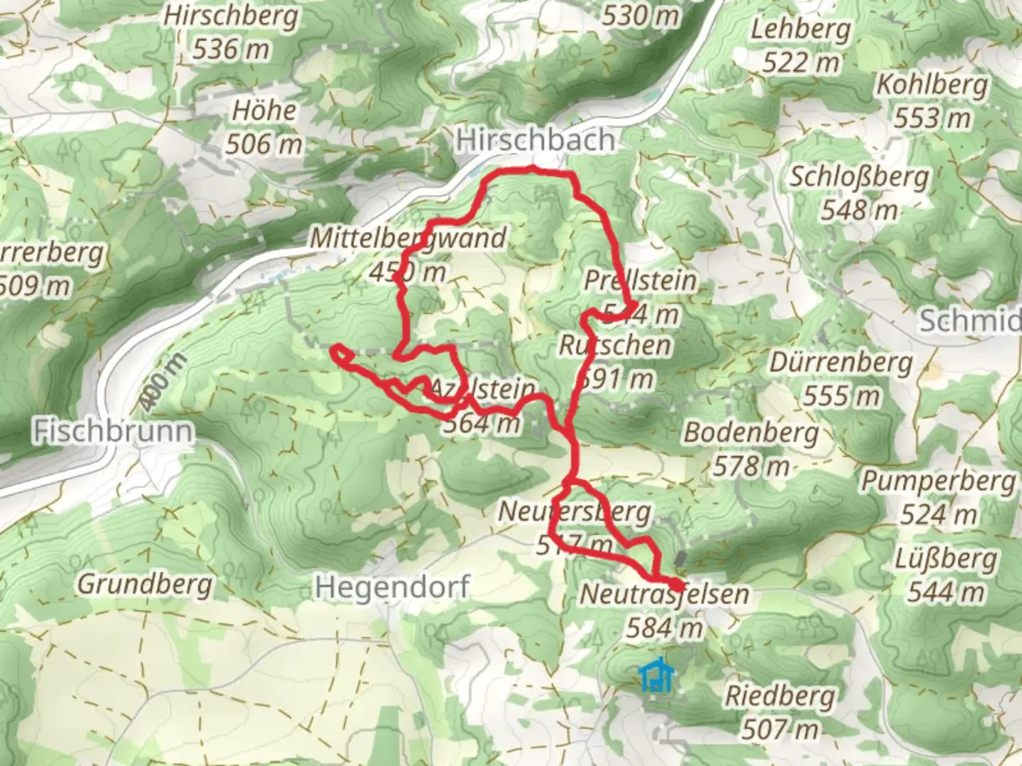
Starting near Amberg-Sulzbach in Germany, this 9 km (approximately 5.6 miles) loop trail offers a moderate challenge with an elevation gain of around 400 meters (about 1,312 feet). The trailhead is conveniently accessible by car or public transport. If you're driving, you can park near the town of Amberg-Sulzbach. For those using public transport, take a train or bus to Amberg-Sulzbach and then a short taxi ride to the trailhead.
Initial Ascent and Francke-Kamin
The trail begins with a gradual ascent through dense forest, providing a serene start to your hike. After about 2 km (1.2 miles), you'll reach the Francke-Kamin, a notable rock formation. This section involves some scrambling, so be prepared with sturdy footwear and possibly trekking poles for added stability. The Francke-Kamin offers a unique geological feature that is worth a short break to explore and photograph.
Mittelbergwand and Scenic Views
Continuing on, the trail leads you to the Mittelbergwand, another significant rock formation. This section is around 4 km (2.5 miles) into the hike and offers panoramic views of the surrounding Bavarian countryside. The elevation gain here is more pronounced, so take your time and enjoy the vistas. The Mittelbergwand is also a popular spot for rock climbing, so you might see climbers scaling its heights.
Flora and Fauna
The trail is rich in biodiversity. As you hike, you'll pass through mixed forests of beech and oak, interspersed with patches of wildflowers in the spring and summer. Keep an eye out for local wildlife, including deer, foxes, and a variety of bird species. The area is particularly known for its population of woodpeckers, so listen for their distinctive drumming sounds.
Historical Significance
The region around Amberg-Sulzbach has a rich history dating back to medieval times. The trail itself passes near several historical landmarks, including remnants of old fortifications and ancient trade routes. These historical elements add an extra layer of interest to your hike, making it not just a physical challenge but also a journey through time.
Navigation and Safety
Given the moderate difficulty of the trail, it's advisable to use a reliable navigation tool like HiiKER to keep track of your progress and ensure you stay on the correct path. The trail is well-marked, but having a digital map can provide extra peace of mind. Make sure to carry enough water, especially during the warmer months, and pack some snacks for energy.
Return to Trailhead
The final stretch of the loop brings you back through the forest, gradually descending towards the trailhead. This section is less strenuous, allowing you to cool down and reflect on the diverse landscapes and historical sites you've encountered. The entire loop typically takes around 3-4 hours to complete, depending on your pace and the number of stops you make along the way.
This trail offers a well-rounded hiking experience with its mix of natural beauty, geological features, and historical significance, making it a must-visit for anyone in the Amberg-Sulzbach area.

What to expect?
Activity types
Comments and Reviews
User comments, reviews and discussions about the Francke-Kamin and Mittelbergwand Loop, Germany.
4.33
average rating out of 5
3 rating(s)