Download
Preview
Add to list
More
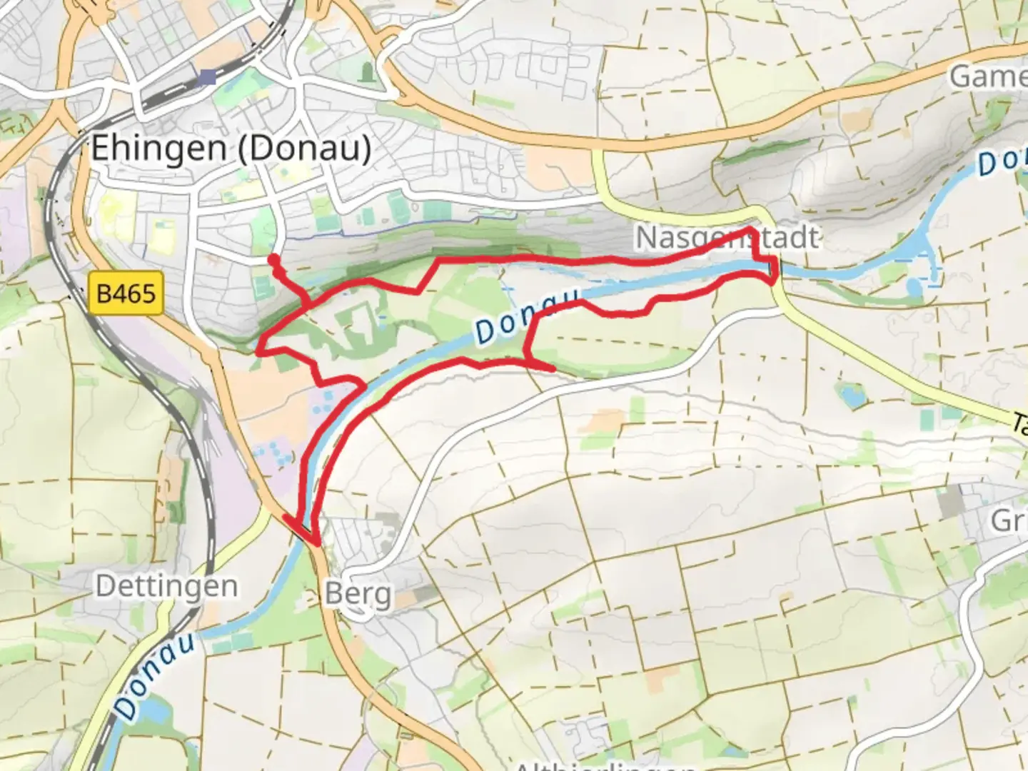
8.9 km
~1 hrs 51 min
54 m
Loop
“The Donau via Naturerfah Rungspfad offers a picturesque, accessible 9 km loop through forests, meadows, and along the Danube.”
Starting near Alb-Donau-Kreis, Germany, the Donau via Naturerfah Rungspfad is a captivating 9 km (5.6 miles) loop trail with virtually no elevation gain, making it accessible to a wide range of hikers. This trail is estimated to be of medium difficulty, offering a balanced mix of natural beauty and moderate physical challenge.
Getting There To reach the trailhead, you can either drive or use public transport. If driving, set your GPS to Alb-Donau-Kreis, Germany. For those using public transport, the nearest significant landmark is the town of Ehingen (Donau), which is well-connected by train. From Ehingen, you can take a local bus or taxi to the trailhead.
Trail Navigation For navigation, it is highly recommended to use the HiiKER app, which provides detailed maps and real-time updates. This will ensure you stay on the correct path and can easily locate points of interest along the way.
Trail Highlights The trail meanders through a variety of landscapes, including dense forests, open meadows, and along the banks of the Danube River. The lack of elevation gain makes it a leisurely walk, allowing you to fully immerse yourself in the natural surroundings.
#### Flora and Fauna The trail is rich in biodiversity. Keep an eye out for native plants like the European Beech and Common Oak. Wildlife enthusiasts might spot deer, foxes, and a variety of bird species, including the European Robin and Great Tit.
#### Historical Significance The region around Alb-Donau-Kreis is steeped in history. The trail itself passes near several historical landmarks, including ancient Roman ruins and medieval castles. Approximately 3 km (1.9 miles) into the hike, you will come across the ruins of a Roman watchtower, offering a glimpse into the area's past as a frontier of the Roman Empire.
Points of Interest - **Danube River**: About 2 km (1.2 miles) into the trail, you will walk alongside the Danube River. This section offers stunning views and is a great spot for a short break. - **Forest Canopy Walk**: Around the 5 km (3.1 miles) mark, the trail features a canopy walk that allows you to experience the forest from a unique vantage point. - **Meadowlands**: Near the end of the loop, the trail opens up into expansive meadows, perfect for a picnic or simply soaking in the scenery.
Practical Information - **Water and Snacks**: There are no facilities along the trail, so bring enough water and snacks to last the entire hike. - **Footwear**: Given the mixed terrain, sturdy hiking boots are recommended. - **Weather**: Check the weather forecast before heading out, as the trail can become slippery in wet conditions.
Safety Tips - **Stay on the Path**: The trail is well-marked, but it's crucial to stay on the designated path to protect the natural environment and avoid getting lost. - **Wildlife**: While encounters with wildlife are rare, it's advisable to keep a safe distance and not feed any animals you might come across.
This trail offers a perfect blend of natural beauty, historical intrigue, and moderate physical activity, making it a must-visit for anyone in the region.

Comments and Reviews
User comments, reviews and discussions about the Donau via Naturerfah Rungspfad, Germany.
5.0
average rating out of 5
2 rating(s)