Download
Preview
Add to list
More
8.8 km
~2 hrs 53 min
679 m
Loop
“Experience breathtaking views and rich history on the rewarding 9 km Gray Crag and Thornthwaite Crag Loop.”
Starting near the picturesque village of Hartsop in Westmorland and Furness, England, the Gray Crag and Thornthwaite Crag Loop offers a rewarding 9 km (5.6 miles) hike with an elevation gain of approximately 600 meters (1,968 feet). This loop trail is rated as medium difficulty, making it suitable for moderately experienced hikers.
Getting There
To reach the trailhead, you can drive to Hartsop, which is accessible via the A592 road. There is a small car park in the village where you can leave your vehicle. If you prefer public transport, the nearest train station is in Penrith, about 20 miles (32 km) away. From Penrith, you can take a bus to Patterdale, which is a short walk from Hartsop.
Trail Overview
The trail begins in Hartsop, a charming village known for its traditional stone cottages and scenic views. As you start your ascent, you'll follow a well-marked path that gradually climbs through open fellside. The initial section is relatively gentle, allowing you to warm up before the steeper sections ahead.
Gray Crag
At around 2 km (1.2 miles) into the hike, you'll reach the base of Gray Crag. The climb becomes steeper here, with rocky terrain underfoot. As you ascend, take a moment to enjoy the panoramic views of the surrounding fells and valleys. Gray Crag itself stands at an elevation of 699 meters (2,293 feet), offering a fantastic vantage point to observe the landscape.
Thornthwaite Crag
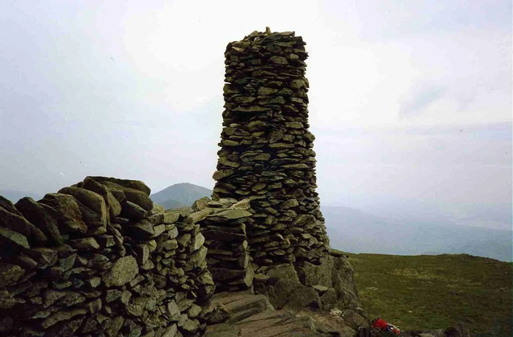
Continuing along the ridge, you'll make your way towards Thornthwaite Crag, which is approximately 4 km (2.5 miles) from the start. The path here is well-defined but can be rocky and uneven, so sturdy footwear is essential. Thornthwaite Crag is notable for its tall stone cairn, known as Thornthwaite Beacon, which stands at 784 meters (2,572 feet). This beacon has historical significance, as it was used as a navigation aid for travelers in the past.
Wildlife and Flora
The area is rich in wildlife, and you may spot red deer, peregrine falcons, and various species of grouse. The flora is equally diverse, with heather, bilberry, and various wildflowers adding splashes of color to the landscape, especially in the summer months.
Descent and Return
From Thornthwaite Crag, the trail descends towards the valley. The descent can be steep in places, so take care, especially if the ground is wet. You'll pass through grassy slopes and eventually rejoin the initial path near Hartsop. The final stretch is a gentle walk back to the village, where you can relax and perhaps visit a local pub for a well-deserved meal.
Navigation
For navigation, it is highly recommended to use the HiiKER app, which provides detailed maps and real-time tracking to ensure you stay on the correct path.
Historical Significance
The region around Hartsop has a rich history, with evidence of ancient settlements and farming practices dating back to the Bronze Age. The stone walls and old farm buildings you see along the trail are remnants of this long history, offering a glimpse into the lives of those who once inhabited this rugged landscape.
This loop trail offers a mix of challenging climbs, stunning views, and a touch of history, making it a memorable hike for those who venture into the heart of the Lake District.

What to expect?
Activity types
Comments and Reviews
User comments, reviews and discussions about the Gray Crag and Thornthwaite Crag Loop, England.
5.0
average rating out of 5
2 rating(s)