Download
Preview
Add to list
More
6.4 km
~1 hrs 37 min
208 m
Loop
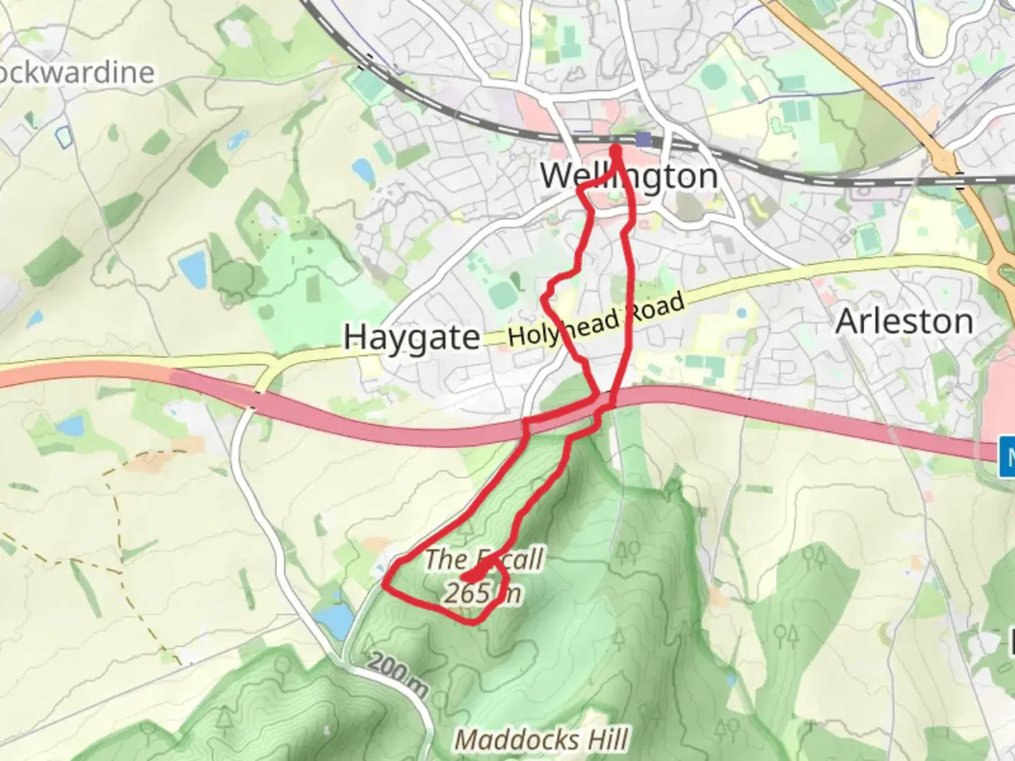
The walk includes rough terrain and hills and is not suitable for wheelchair users. If joining from Wellington Bus Station, cross The Parade at the zebra crossing, then go down the alley to the left of Tin House Restaurant into New Street. Turn right, then after 100m right again into Wellington Market Square. If joining from the railway station, exit the station from Platform 2 onto Station Approach. Walk up Station Approach to Church Street, then turn left into Wellington Market Square. Leave Wellington Market Square heading to the left of the ‘black and white’ building occupied by Subway, then straight on into Crown Street. At the end of Crown Street, bear slightly left up Tan Bank. At the ring road, cross at the pedestrian refuge to your right, turn left, then immediately right to rejoin Tan Bank. At this point you join the Telford T50 50 Mile Trail for most of the first half of the walk. After about 30m take the brick footpath down the alleyway on the right. Cross the next road, Roseway, and continue up the alleyway opposite, passing allotments on your right, and the side of the National Trust property, Sunnycroft, on your left. At the time of writing, Sunnycroft is now only open to the public on special occasions. At the main Holyhead Road, cross using the pelican crossing then continue up Golf Links Lane. Note the grey painted cottage and converted stables on the right. This is the old Hollybush coaching Inn. After passing Ercall Wood Academy, on the former site of Wellington Boys Grammar School, pass under the M54 motorway bridge. About 15m after the bridge, just before the Wrekin Golf Club gates, turn right down some steps and over the footbridge. Bear left uphill into the wood. As the path levels out, for an easier walk, continue straight on, on a gently rising path marked Shropshire Way, and rejoin the walk at point (A) although if you take this route you will miss the ridge and the 3 viewpoints, otherwise, fork right uphill and continue up this path keeping left following the ridge line of The Ercall. As the path levels out again, watch out for a gap in the trees to your left which offers extensive views across the Wrekin Golf Club to Telford Centre and on a clear day, beyond to Cannock Chase. Just before reaching the summit, keep following the path bearing to the right then slightly downhill for about 100m, before taking a sweeping left hand U-turn towards then up alongside the edge of the Ercall Quarry. This point has great views of the Wrekin and to the right of it, across to Shrewsbury and on to the Breidden Hills in Wales. Take the middle path slightly to the left continuing uphill to reach the last of the Ercall’s major viewpoints, this time looking across towards Little Wenlock. The path now heads back into the trees, completing the loop of the summit area before turning right down a steep slope. At the bottom of the slope you reach point (A). If you took the easier route, turn left, otherwise it’s straight on following the widening path all the way down into the quarry. Continue down the wide track passing 2 smaller quarry workings on your right and left. You may notice some of the few remains of the quarry workings, old stone walls and the posts from the quarry gateway. At the end of the track, pass through a wooden kissing gate, alongside the main gate, and turn right onto Ercall Lane. Here is where you say goodbye to the T50. The Buckatree Hall Hotel is on your left. As the lane bends right, then slightly left after the hotel car park, you can either stay on the road walking in the pedestrian / cycle lane, or take one of the access paths onto the woodland path that runs alongside several metres in from the road, although at a few points it rejoins then leaves again. You will eventually reach the Ercall Car Park and continue, this time, over, the M54 motorway. From the bridge, to your right, you can see how the northern end of The Ercall was severed by the motorway’s construction in the mid 1970’s. Immediately after crossing the bridge, take the alleyway on the right along the northern side of the motorway. After 300m, the path descends sharply. At the bottom, before reaching the metal footbridge, turn left. Follow this path, which is partially boardwalk, alongside the stream, it turns sharp left then right onto a wider track which leads to a road. Turn left on Christine Avenue, then at the T-junction, turn right onto Ercall Lane for 70m. Cross to the opposite side before reaching Holyhead Road again. Turn left, on Holyhead Road, then cross the road into Pooler Close. As you continue down Pooler Close follow the signs for No.s 10-60, then 26-58. At the end carry straight on onto a gravel footpath leading to the top of Union Road. You pass one of the entrances to Wellington Cemetery on your left. If you have time, take a wander around it with its huge yew trees, and at the right time of year, splendid displays of rhododendrons. Also note the cemetery chapel with its distinctive archway through the centre. Continue down Union Road, bearing left just before the Wrekin pub, and continue along the ring road to the pelican crossings at the junction with Haygate Road to the left and Walker Street to the right. Cross the ring road and turn left then immediate right into Walker Street. About 80m further along you will pass the old library building on your right. As the road bears to the right, carry straight on into the pedestrian area for 25m before turning left into Duke Street which will bring you back into Market Square. There are numerous places in Wellington centre to find some well-earned refreshments, from take-aways to cafes to eat-in restaurants. If the market is open, you could also try the food quarter where you’ll find several ‘street food’ vendors.

Comments and Reviews
User comments, reviews and discussions about the Wellington - Ercall, England.
average rating out of 5
0 rating(s)