Download
Preview
Add to list
More
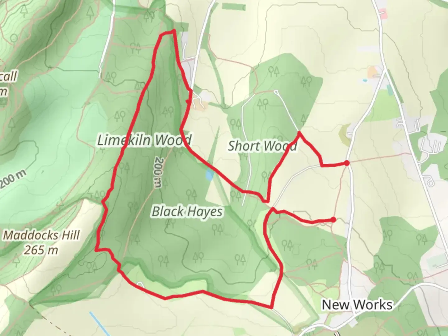
5.5 km
~1 hrs 20 min
143 m
Loop
The walk crosses fields, rough tracks, woodland paths, and is unsuitable for wheelchair or pushchair users. During winter months, several parts of this route are likely to be muddy. There are bus stops for public transport on Dawley Road, approx. 500m away across a rough field path (waymarked as The Hutchison Way). There is parking at the start point for roughly 10-12 cars. Food and refreshments can be purchased at Premier Stores in Lawley Village, or a bit further away at the shops in the new Lawley Centre, which also includes the Grazing Cow pub . Leave the car park turning sharp right up the rough track heading away from New Works Lane. After 130m, turn right at the junction and head towards the woods (Short Woods). Immediately before entering the woods, and before a metal barrier, turn left uphill on a grassy path between a fence on the left and the woods on your right. At the top of this path, stay on the path as it turns right towards the wood to a junction, keep straight ahead to enter the woodland. You join the Telford T50 50 mile trail here. These woods are privately owned so please keep to the path as directed. Keeping straight on, the path descends quite steeply to a stile. Cross the stile and the wide track to the path opposite, crossing the small wooden footbridge over a stream which seeps out of the ground adjacent to the bridge. This may possibly be a spring, or drainage from the coal mines that ran into the hillside which you just descended. The colour of the water here is often brown stained by iron . Continue along this path to another stile which takes you out into an open field. You can clearly see the path across the field as it’s slightly raised, and quite level. This used to be a tramway taking coal from the mines to the limekilns that are in the woods in front of you. Look out to your right across the field and you should see the tower of Christ Church in Wellington. Keep an eye out too for the herd of deer that are often seen in the open here on either side of the field. The path passes between some trees with an old reservoir on the left. This is shown on old maps as Wellington Urban District Council Water Works. After another shorter field you pass through a kissing gate into Limekiln Woods. The gate was installed in 2023 to celebrate the 5th anniversary of the Telford T50 50 Mile Trail. Keep straight ahead till you reach the next junction where you turn right through (or rather, step over) a very low metal gate. At this fork in the path, keep straight on, leaving the T50, going downhill on a rough stone track with a field to your right through the trees. As you start to come level with the farm buildings, keep a look out for a path off to the left, by a large fallen tree stump. This path will take you into the Limekilns, which were supplied with coal from New Works, and limestone and wood from the area now known as Limekiln Woods. The finished product was quicklime which was used as an agricultural fertiliser, and as a flux in the iron making process in the nearby foundries during the start of the industrial revolution. After exploring the Limekilns, return to the path and continue down to the top of Limekiln Lane. Turn left and pass through a gap at the side of a gate, onto a path into the woods with a fence on your right. Stay on this path, ignoring both a path to the right, then a path to the left. Take the next path to the left, which is also marked as the Hutchison Way. Keep to this main path which bends right and left a few times before straightening up, heading uphill. Keep straight on, ignoring any paths off to the right, for approx. 1000m, to reach a T-Junction as the path levels out at the top of the woods with a field in front. Keep your eyes peeled in these woods as there’s a good chance of spotting deer, particularly off to the left. At the junction, this is the highest point on Maddocks Hill, one of the smaller hills of the Wrekin Forest. Turn left and follow this path as it twists and turns downhill to reach another T-junction with the main path through Limekiln Woods. Turn right for 50m then left through a kissing gate, then another gate onto a wide track in an open field. Another good spot to see deer, as they come out of the woods on your left. Follow this track for approx 800m with open fields to the right and a mix of field and woods to the left to reach a junction. Take a left turn here, briefly rejoining the T50, but before you head down this track, take a look over your shoulder for a good view of the Wrekin behind you. Follow this wide track slightly downhill for about 500m. You pass a small pool on the right, although in summer it often dries up, and you may also spot a few information boards that tell you about the mining activity that happened in this area. One of them shows the working of a ‘Bell Pit’ where a shaft was dug to reach the coal seam, then the seam was excavated in an ever increasing circle until there was a danger the roof might collapse. At this point the pit was abandoned and another started close by. Many of the large dips in this area, and in Limekiln Woods, are thought to be the remains of this type of pit that has collapsed, but be wary of going in them as they may still collapse further. As you reach a more open area, there are paths off to the left and to the right. Take the path to the right, which initially threads its way between gorse bushes before running along a fence on your left. From here you get good views out over north-west Telford and can see the tower blocks in Hadley and Ketley, the roofs of the factories at Hortonwood and the Weald Moors in the distance. As the path reaches the end of the fence line, turn left, and follow the fence again which will lead you to a kissing gate opposite the car park entrance where you started your walk.

Comments and Reviews
User comments, reviews and discussions about the New Works, England.
average rating out of 5
0 rating(s)