Download
Preview
Add to list
More
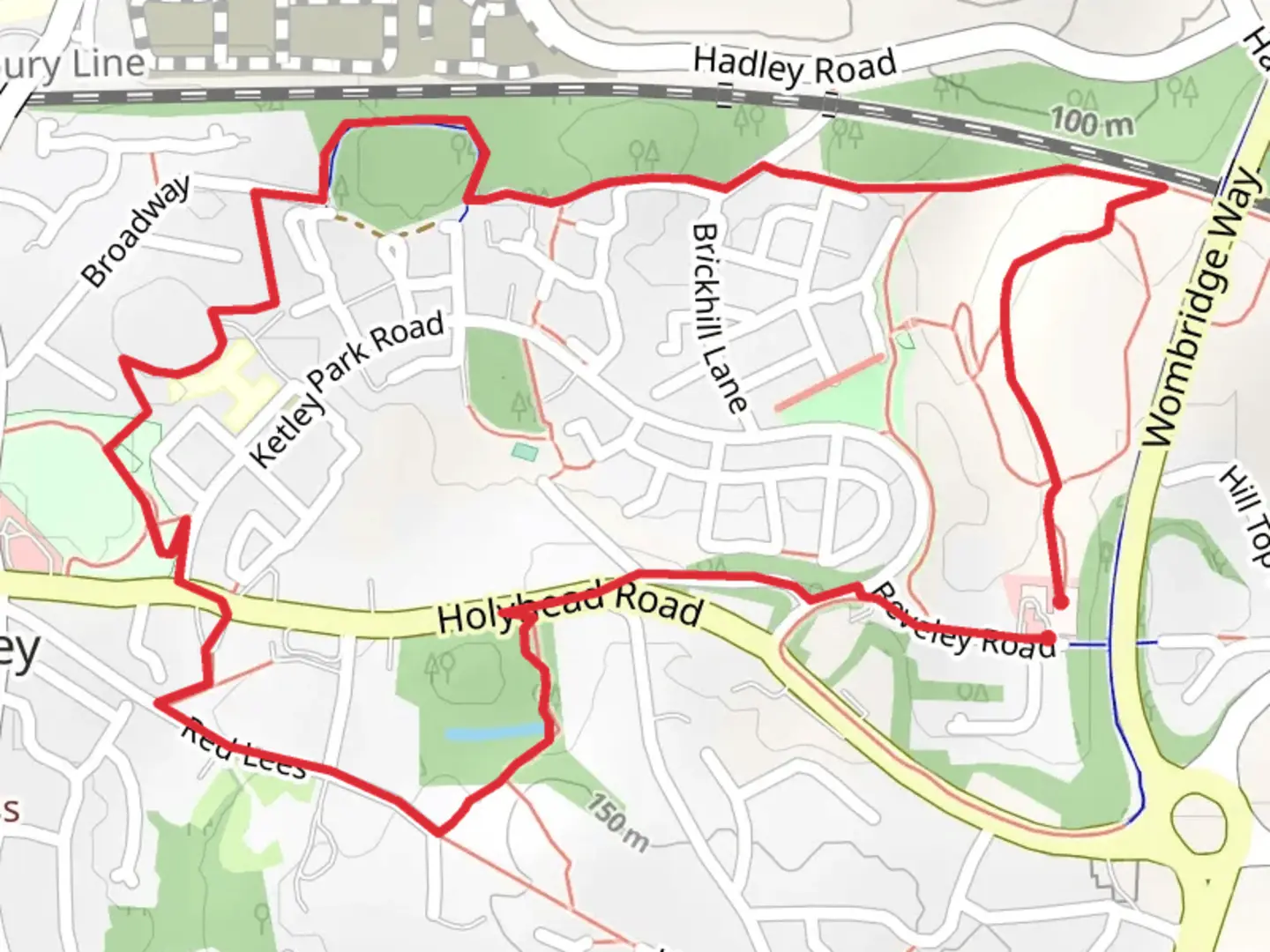
3.4 km
~44 min
41 m
Loop
Leave through the gate by the information board at the end of the car park and continue straight on. The path rises to a path junction. Take the left-hand path and continue on the level path. To the left is a small valley with a stream in its base and woodland, scrub and areas of grassland on the valley sides. This valley is home to many bird and insect species. On the right is the remains of the Beveley Glen landfill site which has been capped and restored for wildlife. There are areas of grassland, heathland and scrub making it valuable for birds, invertebrates and reptiles. The path bends to the right into an open grassy area with fine views over the north Shropshire plain. It is possible to see across to the wooded Haughmond Hill and, on really clear days, to the Berwyn Mountains in Wales. Looking behind you can see the Ercall and the Wrekin whilst closer is Ketley Paddock Mound which we will be visiting later. Continue on the path and at the next path junction turn left, the path descends down towards the railway line. The route now turns sharp left onto a wide track with the railway on the right and a bank of wildflowers and gorse on the left. At the bottom of the slope is a wide concrete bridge and looking down into the valley it is possible to see the stream. Carry on and where the path forks take the right hand fork up and over a small rise then down to a path junction with a pond in a hollow on the right. At the path junction turn left. (If you want a longer walk it is possible to turn right go under the railway bridge and join the route of walk 7 to Middle and Trench Pools, once you get back to the railway bridge having done route 7 rejoin route 10 and continue using the directions below.) As the route approaches houses it turns right with a hedgerow along the right hand side of the path. Follow this path past a small pond on the right. The path curves to the right and ahead there is an information board about the Millennium Reserve. Turn right over a grid across the path. On the left in a hollow is an area of willow scrub with a couple of ponds. This area is often used for events. Frogs and newts use the ponds and the willow scrub is used by birds. The route avoids going through this area by staying on the level path around the woodland perimeter. At another grid across the path turn right and then bear left onto a narrow hedge lined path which turns sharp right after a short distance. Ahead you will see a gate at the entrance to an area of woodland. Don’t go through the gate but turn left on a path between hedges. The path now runs at the back of a retirement home, keep following the path as it eventually turns left and then right before it brings you out onto playing fields with a play area. Join a tarmac footpath at the corner of the play area and turn left. Just beyond the play area take the left branch of the path which winds up the hill to avoid steps until it reaches the road. Turn right and continue a short distance to the mini roundabout. Turn left, use the pedestrian to cross the B5061 (old A5) and turn left. After a few yards turn right , continue straight on at a junction. On the left is a wall made of carboniferous sand and gritstone that formed layers between the coal measures. Some of the coping stones are made out of a block of slag from the iron smelting and have a glassy look to them. The path bears right and after a short distance brings you out on a lane (Red Lees) which in former times was a tramway. Turn left and walk up the lane which is a bit rough in places. As the lane climbs there are more walls on the right made of local stone and furnace slag. Continue uphill until you come to a waste bin with a gate on the left which is the entrance to Ketley Paddock Mound Local Nature Reserve an 11 acre nature reserve owned by Telford and Wrekin Council . (You could continue on Red Lees, until a gap on your left, where you should see T50 signs pointing up steps, just ahead is a Covid stone snake which you might like to visit. Go up the steps to Paddock Mound, once on the top you could retrace your steps to the gap on Red Lees, or cross , following the T50 to go down the steeper steps, then turn right rejoining the route at * ) Go through the gap at the side of the gate and continue on the level path. On the right is a pond with a dipping platform.* Continue on the level path with the until you reach a set of steps descending on the left. The steps are wide and shallow but those with a push chair will probably need help. Go down the steps and on the left you will see a long pond which is the remains of the Ketley Canal which brought coal and ironstone to Ketley Ironworks in tub boats. On the right of the path opposite the canal is an earth bank where there was once a tunnel taking the canal under Shepherds Lane. The canal remains betrays the industrial origins of this now wildlife-rich piece of greenspace. Colliery waste from local mines was dumped to form two tall and steep-sided mounds. Once the mines closed these have gradually been colonized by wildlife so today there is a mix of woodland, acidic grassland, ponds and wetland home to a variety of birds, amphibians, mammals and invertebrates. Beyond the canal the path descends another short set of steps and passes another pond on the left before leaving the nature reserve by a gate onto the A5. Notice the bus shelter decorated with a wildlife mural celebrating the wildlife of Ketley Paddock Mound. For safety it is best to turn left and cross the A5 by the pedestrian crossing before turning right and retracing you steps on the other side of the road. Carry on and veer left onto Beveley Road at the Cardamom restaurant. Carry straight on down Beveley Road avoiding the left turn taken by the T50 route. At the next junction turn left, cross the road then walk down another branch of Beveley Road to The Compasses Inn and the carpark.

Comments and Reviews
User comments, reviews and discussions about the Ketley, England.
average rating out of 5
0 rating(s)