Download
Preview
Add to list
More
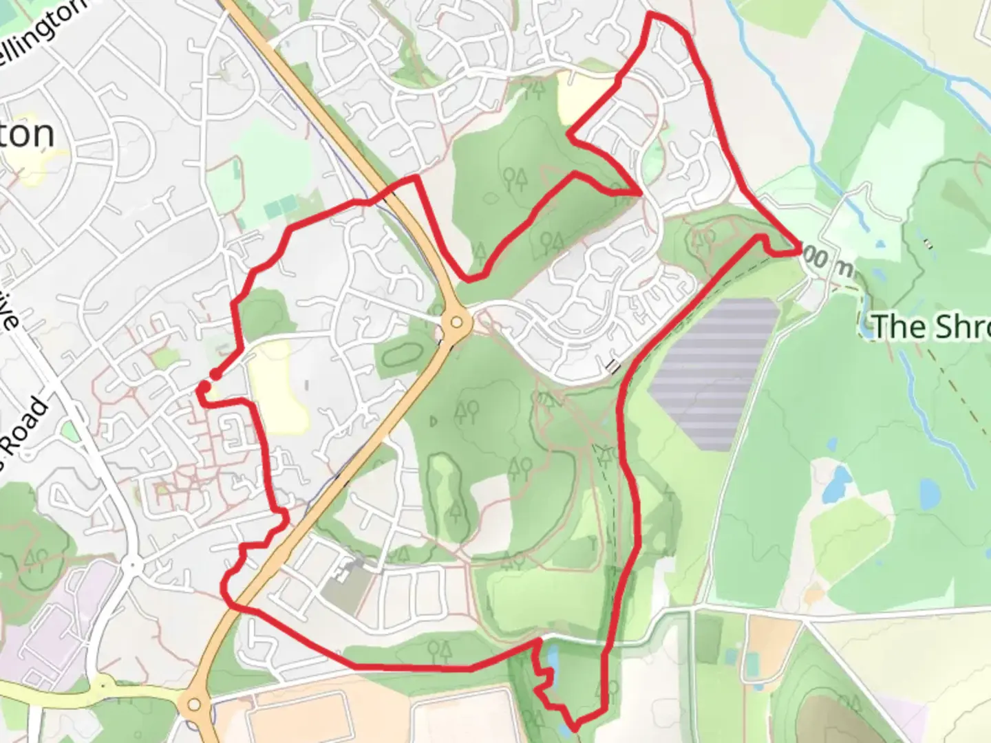
6.2 km
~1 hrs 20 min
62 m
Loop
The walk crosses fields, rough tracks, and includes steps, and is unsuitable for wheelchair or pushchair users. There are bus stops for public transport on St Georges Road a short distance away (400m-450m). There is lay-by parking 100m away towards St Matthews Church. Please do not park in the Community Hub car park as this is for the users of the Hub. Food and refreshments can be purchased at the shops on Wrekin Drive in Donnington. Leave the Community Hub by taking the footpath to the right of the car park and children’s play area. At the end of the play area take the left fork along the path behind the Community Hub to reach St Matthews C of E Primary School straight ahead of you. Turn right and follow the path into Bradley Road. As the road bends sharply right at the top, turn left then soon right through an opening, just along from a gate, into a grassy field and follow the well worn path bearing right to exit through a gate then between iron railings into the end of a cul-de-sac. At the junction 50m ahead, turn left, then take the next right to the end of another cul-de-sac. Continue ahead onto the narrow gravel path between 2 hedges to the right of a driveway. The path bears to the left to reach the main road, Donnington Wood Way. Cross over the main road at the Pelican crossing and into the alleyway straight ahead for 300m. Turn left along Granville Road. This is a narrow lane with speed humps to slow down the traffic, and can be busy with traffic to and from both Granville Car Park, and the Shropshire Golf Club. There is a footpath on the right, set back slightly, separated from the road by a grassy mound, but can be quite muddy at times. Take extra care if you prefer to walk along the lane. If you took the footpath option, at the kissing gate you can go straight through and follow the path to a T-junction, this path can also be quite muddy, then turn right, or you can drop down onto the lane and continue on for a further 100m. If you’re on the lane, you can turn right up the bank through the kissing gate mentioned above, or continue along the lane and turn right though a kissing gate with an information board to its left. Follow the path into the woods, then turn left onto a narrow path to the canal basin. Take care here as there is no barrier or fence along the edge of the canal. Follow the edge for a short distance then follow the path bearing to the right to re-join the main path, turning right then immediately left slightly uphill to pass in front of the old Lodge Furnaces on your right. Follow the path to again rejoin the main path turning right. As you reach a pool on your right, take the bridleway to your left, keeping to the left of the central railings and follow this to emerge through a kissing gate onto Granville Road again, directly opposite the entrance to Granville Country Park Car Park. Cross straight over and go through the car park. At the far end of the car park take the ascending wooden steps to reach Top of The World, a bench with views out to the west across Telford and beyond. On a clear day you can see the Berwyn Hills. Continue straight on from the bench keeping close to the hedgerow on your left and descend the wooden steps – take care, some of the steps are quite deep. At the bottom of the steps, turn right on a wide track, pass the information board about Waxhill Colliery Barracks, and continue ahead through 2 kissing gates. The track is now separated into footpath and bridleway, so keep the left of the central railings. Continue on this track ignoring any paths on the left or right. As you reach the ruins of Muxton Bridge Winding house, the path bears to the right, then to the left before reaching another car park. Pass through the kissing gate, and straight through the car park, turning left downhill on Muxton Lane. You shortly pass the entrance to The Shropshire Golf Club on your right. Continue along the lane for 700m, then turn left up a tarmac alleyway through a staggered metal barrier. After 160m, at the crossing, cross over Marshbrook Way, turn right then immediately left to take the alleyway keeping Muxton Primary School on your right. After passing the school, the alleyway bends to the left, then after 200m, as it comes close to the main road on your left, and just before it bends to the right, turn right up some steep wooden steps into the woods. At the top of the steps, bear right and follow the narrow path, taking the next turn on your left on another narrow path. You should then join a wider track coming in from your right, and continue straight ahead. At the next junction, before reaching the road ahead, turn right, then almost immediately, right again through a gate and into a field, this is Muxton Marsh. The path bears slightly to the left to cross a small footbridge through a gap in the hedgerow, then right almost alongside the hedgerow to a kissing gate in the corner of the field. Go through the gate and turn left on a tarmac track. Continue ahead, through an underpass beneath Donnington Wood Way, keeping straight ahead to pass though another kissing gate onto a lane on a corner. Turn left and follow the lane which bends to the left, then right. At the fork in the lane, keep left to reach Church Road, then turn leftt uphill passing Bishops Walk, and St Matthews Church on your right. At the junction turn right onto St Matthews Road keeping the church on your right. Continue along the road, crossing over to return to Donnington Community Hub to compete your walk.

Comments and Reviews
User comments, reviews and discussions about the Donnington Wood, England.
average rating out of 5
0 rating(s)