Download
Preview
Add to list
More
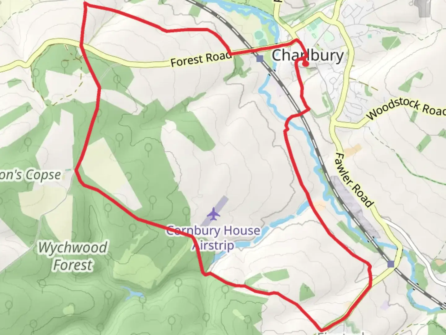
11.8 km
~2 hrs 43 min
215 m
Loop
“Explore serene woodlands, open fields, and historical landmarks on this rewarding 12 km Oxfordshire trail.”
Starting near the picturesque village of Nettlebed in Oxfordshire, England, the Little Cranehill Copse and Shock's Copse Loop is a delightful 12 km (7.5 miles) loop trail with an elevation gain of approximately 200 meters (656 feet). This medium-difficulty trail offers a blend of serene woodland, open fields, and historical landmarks, making it a rewarding experience for hikers of all levels.
Getting There To reach the trailhead, you can drive to Nettlebed, which is easily accessible via the A4130 road. There is limited parking available near the village center. For those using public transport, the nearest major railway station is Henley-on-Thames. From there, you can take a local bus service to Nettlebed, which is about a 20-minute ride.
Trail Navigation For navigation, it is highly recommended to use the HiiKER app, which provides detailed maps and real-time updates to ensure you stay on the correct path.
Trail Highlights #### Little Cranehill Copse Starting from Nettlebed, the trail initially takes you through Little Cranehill Copse, a dense woodland area known for its rich biodiversity. Keep an eye out for native bird species such as the Great Spotted Woodpecker and the Eurasian Nuthatch. The forest floor is often carpeted with bluebells in the spring, creating a stunning visual treat.
#### Open Fields and Farmland After exiting Little Cranehill Copse, the trail opens up into expansive fields and farmland. This section offers panoramic views of the rolling Oxfordshire countryside. The gentle undulations of the terrain here contribute to the overall elevation gain, but the path remains well-trodden and easy to follow.
#### Shock's Copse As you approach the halfway mark, you'll enter Shock's Copse, another beautiful woodland area. This section of the trail is particularly enchanting in autumn when the leaves turn vibrant shades of red and gold. The copse is also home to various small mammals, including squirrels and hedgehogs, so tread lightly and you might spot one.
Historical Significance The region around Nettlebed has a rich history dating back to the Roman era. Along the trail, you may come across remnants of ancient Roman roads and boundary markers. Nettlebed itself was historically significant for its brick and tile industry, which thrived from the 14th to the 19th century. The village's old kilns and brickworks are a testament to this industrial past and can be seen near the trailhead.
Practical Information - **Distance:** 12 km (7.5 miles) - **Elevation Gain:** 200 meters (656 feet) - **Difficulty:** Medium - **Best Time to Hike:** Spring and autumn offer the most pleasant weather and scenic beauty. - **Facilities:** There are no facilities directly on the trail, so bring sufficient water and snacks. The village of Nettlebed has a few pubs and shops where you can refresh before or after your hike.
Wildlife and Flora The trail is a haven for wildlife enthusiasts. Besides the birds and small mammals, you might also encounter deer grazing in the open fields. The flora is equally diverse, with ancient oak and beech trees dominating the woodlands, and wildflowers like primroses and foxgloves adding splashes of color along the way.
Safety Tips - Wear sturdy hiking boots as some sections can be muddy, especially after rain. - Check the weather forecast before heading out and dress in layers. - Use the HiiKER app for navigation to avoid getting lost.
This trail offers a perfect blend of natural beauty, historical intrigue, and moderate physical challenge, making it a must-visit for anyone exploring the Oxfordshire countryside.

What to expect?
Activity types
Comments and Reviews
User comments, reviews and discussions about the Little Cranehill Copse and Shock's Copse Loop, England.
4.67
average rating out of 5
3 rating(s)