Download
Preview
Add to list
More
12.1 km
~4 hrs 0 min
948 m
Loop
“Explore the breathtaking 12 km Bleaberry Tarn, Red Pike, and High Crag Loop near Buttermere, Cumberland.”
Starting your adventure near the picturesque village of Buttermere in Cumberland, England, the Bleaberry Tarn, Red Pike, and High Crag Loop is a captivating 12 km (7.5 miles) loop trail with an elevation gain of approximately 900 meters (2,950 feet). This trail offers a medium difficulty rating, making it suitable for hikers with a moderate level of experience and fitness.
Getting There To reach the trailhead, you can drive to Buttermere, where parking is available near the village. If you prefer public transport, buses run from Keswick to Buttermere, providing a convenient option for those without a car. The nearest significant landmark to the trailhead is the Buttermere village center.
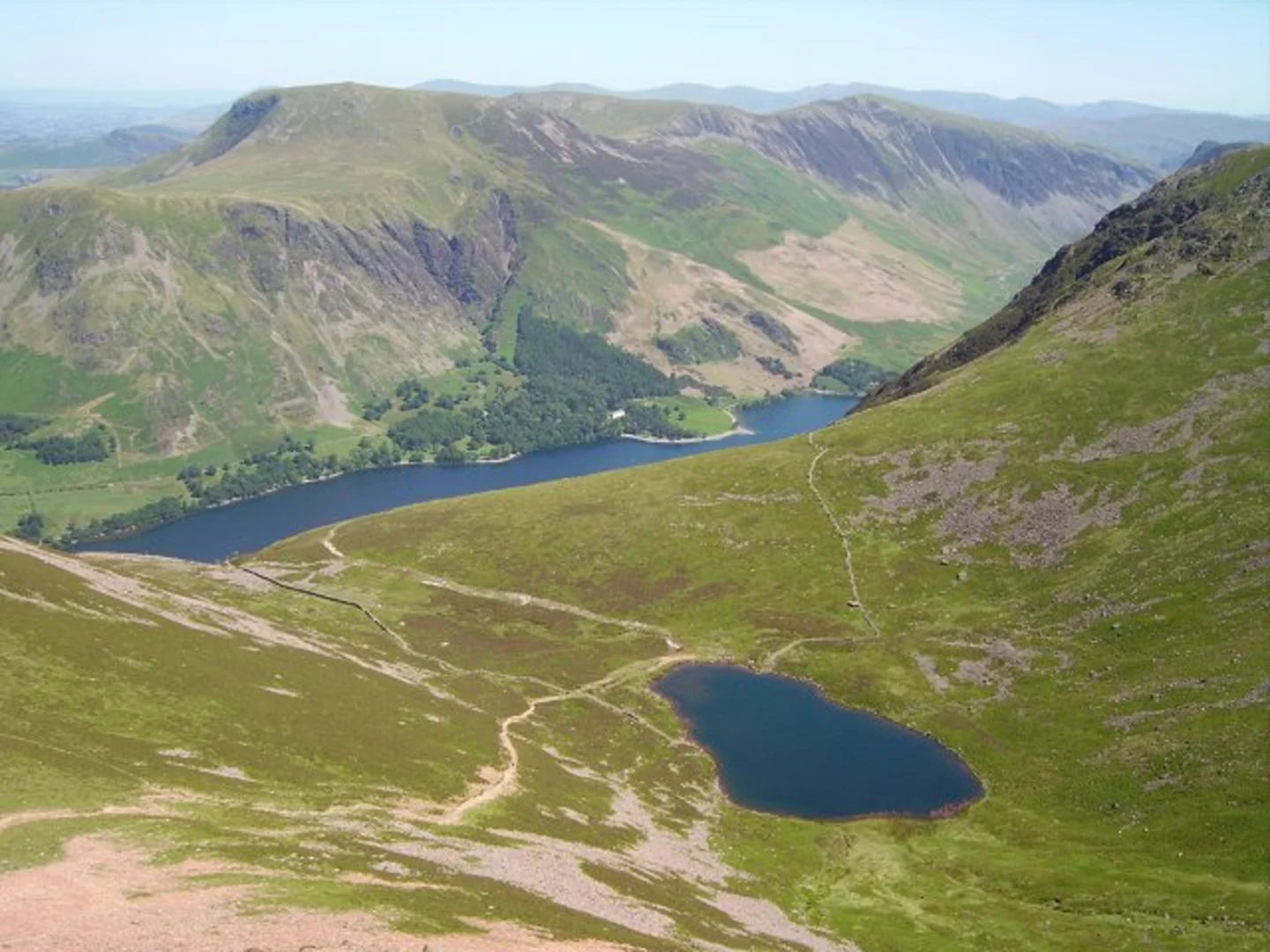
Trail Overview The trail begins in Buttermere, a charming village nestled between the lakes of Buttermere and Crummock Water. As you set off, you'll be greeted by the serene beauty of the Buttermere Valley, with its lush greenery and tranquil waters.
Bleaberry Tarn Approximately 3 km (1.9 miles) into the hike, you'll reach Bleaberry Tarn, a stunning glacial lake situated beneath the towering cliffs of Red Pike. The ascent to the tarn is steep, gaining around 300 meters (985 feet) in elevation, but the effort is rewarded with breathtaking views of the tarn's clear waters and the surrounding fells. This is an excellent spot for a short rest and some photography.
Red Pike Continuing from Bleaberry Tarn, the trail ascends further to the summit of Red Pike, which stands at 755 meters (2,477 feet). The climb is challenging, with rocky and uneven terrain, but the panoramic views from the top are spectacular. On a clear day, you can see as far as the Isle of Man and the Scottish coast. The descent from Red Pike is steep and requires careful footing, especially in wet conditions.
High Crag The next significant landmark is High Crag, which you will reach after a ridge walk from Red Pike. This section of the trail is about 2 km (1.2 miles) and involves a descent followed by another ascent. High Crag stands at 744 meters (2,441 feet) and offers equally impressive views of the surrounding landscape. The ridge walk can be exposed, so be prepared for windy conditions.
Descent and Return From High Crag, the trail descends steeply towards Scarth Gap Pass. This section can be particularly challenging due to loose scree and rocky paths. Once you reach Scarth Gap Pass, the trail becomes more manageable as it winds its way back down to Buttermere. The final stretch of the hike takes you along the shores of Buttermere Lake, providing a peaceful and scenic end to your journey.
Historical Significance The Buttermere area is steeped in history, with evidence of human activity dating back to the Bronze Age. The village itself has a rich history, with connections to the early Christian church and the medieval period. The surrounding fells have long been a source of inspiration for poets and writers, including William Wordsworth, who was captivated by the natural beauty of the region.
Wildlife and Nature Throughout the hike, you'll have the opportunity to observe a variety of wildlife. Red squirrels, deer, and a wide range of bird species, including peregrine falcons and buzzards, are commonly seen in the area. The diverse flora includes ancient woodlands, heather moorlands, and alpine plants, making this trail a haven for nature enthusiasts.
Navigation For navigation, it is highly recommended to use the HiiKER app, which provides detailed maps and real-time tracking to ensure you stay on the right path. The trail is well-marked, but having a reliable navigation tool can enhance your hiking experience and provide peace of mind.
Prepare adequately for this hike by bringing appropriate gear, including sturdy hiking boots, weather-appropriate clothing, and plenty of water and snacks. The weather in the Lake District can be unpredictable, so be prepared for sudden changes.

What to expect?
Activity types
Comments and Reviews
User comments, reviews and discussions about the Bleaberry Tarn, Red Pike and High Crag Loop via Buttermere, England.
4.75
average rating out of 5
4 rating(s)