Download
Preview
Add to list
More
66.0 km
~3 day
2523 m
Point-to-Point
“Embark on an epic adventure through breathtaking alpine lakes, rugged peaks, and diverse wildlife on the challenging John Muir Trail.”
Getting to the Trailhead
The Cottonwood Lakes and Guitar Lake via John Muir Trail begins near Inyo County, California. To reach the trailhead, you can drive to the Horseshoe Meadow Campground, which is accessible via Horseshoe Meadow Road from Lone Pine, California. Lone Pine is a small town located along U.S. Route 395, and it serves as a convenient base for hikers. If you're relying on public transport, you can take a bus to Lone Pine from larger cities like Los Angeles, and then arrange for a taxi or shuttle service to the trailhead.
Trail Overview
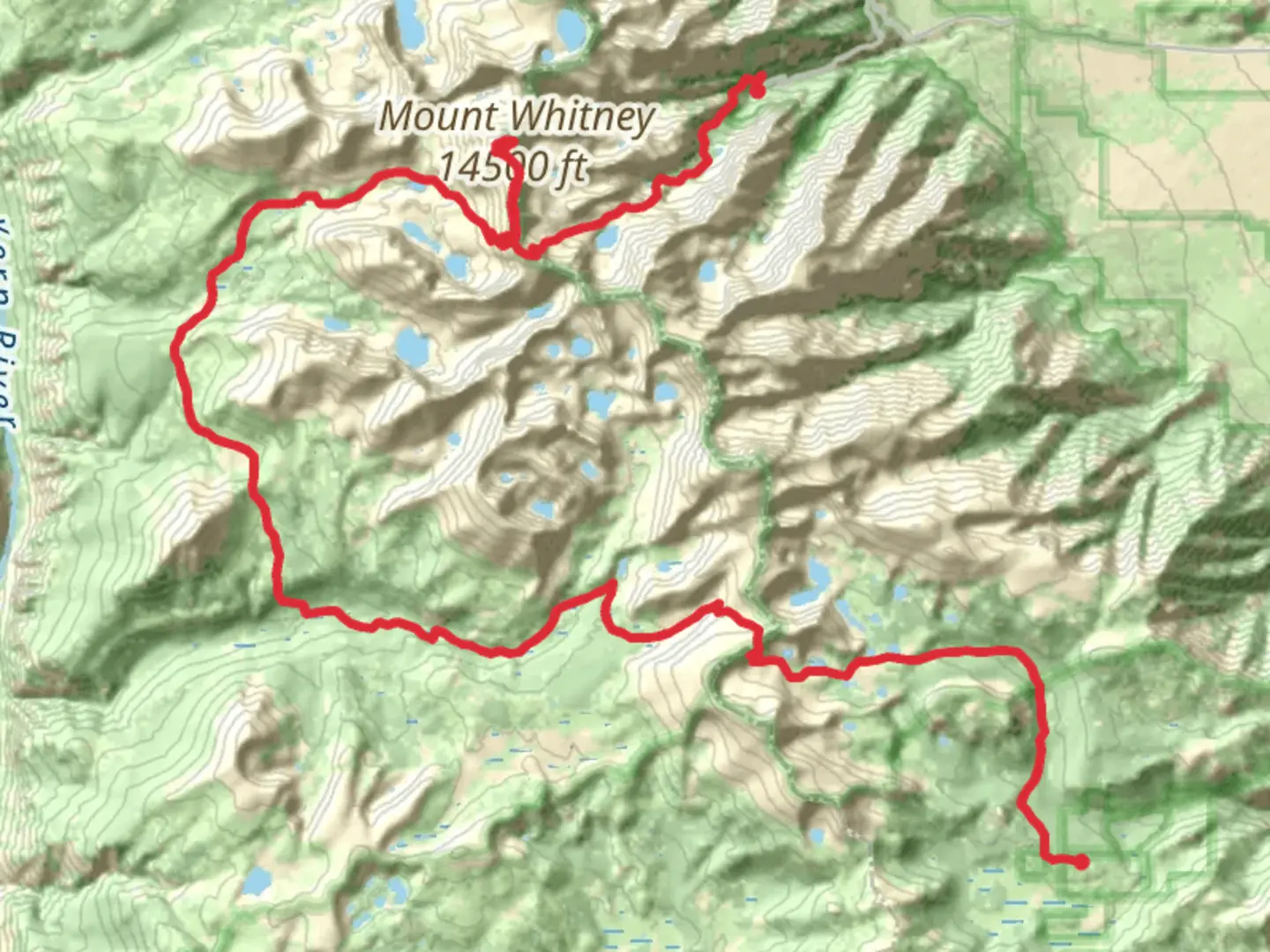
This point-to-point trail stretches approximately 66 kilometers (about 41 miles) with an elevation gain of around 2,500 meters (8,200 feet). The trail is rated as extra difficult, making it suitable for experienced hikers who are well-prepared for challenging terrain and high altitudes. The journey takes you through some of the most stunning landscapes in the Sierra Nevada, offering a mix of alpine lakes, rugged peaks, and expansive meadows.
Key Landmarks and Natural Features
Cottonwood Lakes The trail begins with a gradual ascent through the Cottonwood Lakes Basin, a series of picturesque alpine lakes surrounded by towering peaks. This area is known for its pristine beauty and is a popular spot for fishing and camping. The lakes are nestled at an elevation of around 3,353 meters (11,000 feet), providing a serene start to your adventure.
New Army Pass As you continue, you'll encounter New Army Pass, a high mountain pass that offers breathtaking views of the surrounding Sierra Nevada range. The pass sits at an elevation of approximately 3,780 meters (12,400 feet) and can be challenging due to its steep and rocky terrain. Be prepared for snow patches, even in the summer months.
Guitar Lake Further along the trail, you'll reach Guitar Lake, aptly named for its shape resembling a guitar. This is a popular camping spot for hikers preparing to summit Mount Whitney, the highest peak in the contiguous United States. The lake is situated at an elevation of about 3,505 meters (11,500 feet) and offers stunning reflections of the surrounding peaks.
Wildlife and Flora
The trail traverses diverse ecosystems, from lush meadows to rocky alpine zones. Keep an eye out for wildlife such as mule deer, marmots, and the elusive Sierra Nevada bighorn sheep. Birdwatchers may spot species like the Clark's nutcracker and mountain bluebird. The flora varies with elevation, featuring wildflowers, ancient foxtail pines, and hardy alpine plants.
Historical Significance
The John Muir Trail, which this route partially follows, is named after the famous naturalist John Muir, who was instrumental in the establishment of national parks in the United States. The trail is a testament to his legacy and the conservation efforts that have preserved these wild landscapes for future generations.
Navigation and Preparation
Given the trail's difficulty and remote nature, it's crucial to be well-prepared. Use HiiKER for detailed maps and navigation tools to ensure you stay on course. Weather conditions can change rapidly, so pack appropriate gear for cold and wet weather, even in summer. Ensure you have a permit for overnight camping, as this is required for the area.

What to expect?
Activity types
Comments and Reviews
User comments, reviews and discussions about the Cottonwood Lakes and Guitar Lake via John Muir Trail, California.
average rating out of 5
0 rating(s)