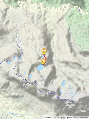
Bald Mountain East Peak via Walt Bailey Trail
Mt. Baker-Snoqualmie National Forest · Snohomish County, Washington
13.5 km
~4 hrs 19 min
982 m
“Embark on a medium-difficulty 13 km hike through lush forests and alpine meadows to Bald Mountain East Peak for stunning Pacific Northwest views.”
Starting your adventure near Snohomish County, Washington, the Bald Mountain East Peak via Walt Bailey Trail offers a rewarding 13 km (8 miles) out-and-back journey with an elevation gain of approximately 900 meters (2,950 feet). This medium-difficulty trail is perfect for those looking to experience the beauty of the Pacific Northwest.### Getting There
To reach the trailhead, you can drive or use public transportation. If driving, head towards the Mountain Loop Highway from Granite Falls, Washington. The nearest significant landmark is the Verlot Public Service Center, located at 33515 Mountain Loop Hwy, Granite Falls, WA 98252. From there, continue on the Mountain Loop Highway for about 16 miles until you reach the trailhead parking area. Public transport options are limited, so driving is recommended.### Trail Overview
The trail begins with a gentle ascent through a lush forest of Douglas fir, western hemlock, and cedar trees. The first 2 km (1.2 miles) are relatively easy, with a gradual elevation gain of about 150 meters (500 feet). As you hike, keep an eye out for the diverse flora and fauna, including ferns, mosses, and various bird species.### Significant Landmarks
Around the 3 km (1.9 miles) mark, you'll encounter the first significant landmark: a series of small, picturesque waterfalls cascading down the rocks. This is a great spot to take a short break and enjoy the serene surroundings.Continuing on, the trail becomes steeper, gaining another 300 meters (1,000 feet) in elevation over the next 2 km (1.2 miles). As you ascend, the forest begins to thin out, offering glimpses of the surrounding mountains and valleys. At approximately 5 km (3.1 miles), you'll reach the first of several alpine meadows. These meadows are often filled with wildflowers in the spring and summer, providing a colorful contrast to the green forest.### Historical Significance
The region has a rich history, with the trail itself named after Walt Bailey, a local conservationist who played a significant role in preserving the natural beauty of the area. The Mountain Loop Highway, which you used to access the trailhead, was originally constructed in the 1930s as part of a New Deal project to provide jobs during the Great Depression.### Final Ascent
The final 1.5 km (0.9 miles) to the East Peak of Bald Mountain is the most challenging part of the hike, with an elevation gain of about 450 meters (1,500 feet). The trail becomes rocky and steep, requiring careful footing. However, the effort is well worth it. As you reach the summit, you'll be rewarded with panoramic views of the surrounding peaks, including Mount Pilchuck, Three Fingers, and Whitehorse Mountain.### Wildlife and Nature
Throughout your hike, be on the lookout for local wildlife. Black bears, deer, and mountain goats are known to inhabit the area. Birdwatchers will also enjoy spotting species such as the varied thrush, Steller's jay, and the occasional bald eagle soaring overhead.### Navigation
For navigation, it's highly recommended to use HiiKER, which provides detailed maps and real-time updates on trail conditions. This will ensure you stay on the right path and can safely enjoy your hike.### Return Journey
After taking in the breathtaking views from the summit, retrace your steps back to the trailhead. The descent offers a different perspective of the landscape, allowing you to appreciate the trail's beauty from a new angle.Prepare adequately with water, snacks, and appropriate gear, and you'll have a memorable experience on the Bald Mountain East Peak via Walt Bailey Trail.
Reviews
User comments, reviews and discussions about the Bald Mountain East Peak via Walt Bailey Trail, Washington.
4.0
average rating out of 5
1 rating(s)
Loading reviews...


