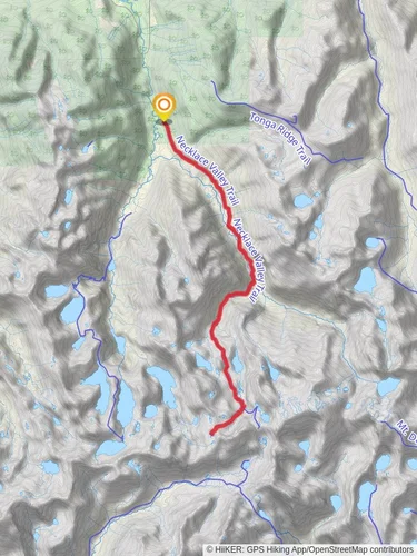
Fisher Lake via Tonga Ridge Trail
Mt. Baker-Snoqualmie National Forest · King County, Washington
14.3 km
~3 hrs 53 min
624 m
“Embark on a scenic, moderately challenging hike through lush forests and panoramic ridges to serene Fisher Lake.”
Starting your journey near King County, Washington, the trailhead for the Fisher Lake via Tonga Ridge Trail is accessible by car. From Seattle, take I-90 East to exit 34, then follow SE North Bend Way and Middle Fork Road to the trailhead. Public transport options are limited, so driving is recommended.
The trail spans approximately 14 km (8.7 miles) with an elevation gain of around 600 meters (1,968 feet), making it a moderately challenging hike. The trail is an out-and-back type, so you'll return the same way you came.
### Initial Ascent and Terrain
The hike begins with a steady ascent through dense forest, where you'll be surrounded by towering Douglas firs and Western hemlocks. The first 3 km (1.9 miles) involve a gradual climb, gaining about 200 meters (656 feet) in elevation. The trail is well-marked and maintained, but be prepared for some rocky and root-covered sections.
### Mid-Trail Highlights
Around the 4 km (2.5 miles) mark, you'll reach a ridge that offers stunning panoramic views of the surrounding mountains, including Mount Daniel and Mount Hinman. This is a great spot to take a break and soak in the scenery. From here, the trail continues along the ridge, providing a mix of gentle ascents and descents.
### Flora and Fauna
As you hike, keep an eye out for the diverse flora and fauna. In the summer months, the trail is adorned with wildflowers like lupines and Indian paintbrush. Wildlife sightings are common, including black bears, deer, and various bird species such as the Stellar's Jay and the American Dipper.
### Historical Significance
The Tonga Ridge area has a rich history, once being a hunting ground for the indigenous Snoqualmie people. The name "Tonga" is believed to be derived from a native word meaning "high place," reflecting the ridge's elevated position.
### Final Stretch to Fisher Lake
The final 3 km (1.9 miles) to Fisher Lake involve a steeper descent, dropping about 150 meters (492 feet) in elevation. The trail narrows and becomes more rugged, so watch your footing. As you approach Fisher Lake, the forest opens up to reveal the serene, crystal-clear waters of the lake, surrounded by alpine meadows.
### Navigation and Safety
For navigation, it's highly recommended to use the HiiKER app, which provides detailed maps and real-time GPS tracking. Ensure you have downloaded the trail map before setting out, as cell service can be spotty.
### Return Journey
After enjoying the tranquility of Fisher Lake, retrace your steps back to the trailhead. The return journey offers a different perspective of the landscape, and the descent is generally easier on the legs.
This trail offers a rewarding mix of natural beauty, historical significance, and moderate physical challenge, making it a must-visit for hikers in the Washington area.
Reviews
User comments, reviews and discussions about the Fisher Lake via Tonga Ridge Trail, Washington.
5.0
average rating out of 5
11 rating(s)


