Heather Basin Trail
22.5 km
~1 day 1 hrs
1059 m
“The Heather Basin Trail in Clallam County offers a 23-kilometer hike through lush forests, vibrant meadows, and breathtaking mountain views.”
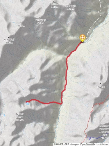
Starting near Clallam County, Washington, the Heather Basin Trail is an out-and-back trail that stretches approximately 23 kilometers (14.3 miles) with an elevation gain of around 1000 meters (3280 feet). This trail is rated as medium difficulty, making it suitable for moderately experienced hikers.
### Getting There To reach the trailhead, you can drive or use public transportation. If driving, head towards the Olympic National Park area, specifically near the Hurricane Ridge Visitor Center. The nearest significant landmark is the Hurricane Ridge Visitor Center, which is well-signposted and offers ample parking. For those using public transport, you can take a bus to Port Angeles and then a taxi or rideshare service to the Hurricane Ridge Visitor Center.
### Trail Overview The trail begins with a gentle ascent through lush, dense forests typical of the Pacific Northwest. The first few kilometers (miles) are relatively easy, allowing you to acclimate to the terrain. As you progress, the trail becomes steeper, and the forest canopy opens up, offering glimpses of the surrounding mountains.
### Flora and Fauna The Heather Basin Trail is rich in biodiversity. In the lower sections, you'll encounter towering Douglas firs and western hemlocks. As you ascend, the vegetation transitions to subalpine meadows filled with wildflowers like lupines and Indian paintbrush during the summer months. Keep an eye out for wildlife; black-tailed deer, marmots, and even black bears are known to inhabit the area. Birdwatchers will also be delighted by the variety of species, including the elusive marbled murrelet.
### Significant Landmarks Around the 8-kilometer (5-mile) mark, you'll come across a stunning viewpoint known as Sunrise Point. This spot offers panoramic views of the Olympic Mountains and is an excellent place for a rest and some photography. Continuing on, the trail becomes more rugged and challenging, with several switchbacks leading you higher into the basin.
### Historical Significance The Heather Basin area holds historical significance as it was once traversed by Native American tribes for hunting and gathering. The region is also part of the Olympic National Park, established in 1938 to preserve the unique ecosystems and landscapes of the Olympic Peninsula.
### Navigation and Safety Given the trail's moderate difficulty, it's advisable to use a reliable navigation tool like HiiKER to keep track of your progress and ensure you stay on the correct path. The trail is well-marked, but weather conditions can change rapidly, especially at higher elevations. Always check the weather forecast before you set out and be prepared for sudden changes.
### Final Ascent The final stretch to Heather Basin is the most challenging, with a steep climb that rewards you with breathtaking views of the basin itself. The basin is a serene, open area surrounded by rugged peaks, making it a perfect spot for a well-deserved break before you begin your descent.
### Return Journey As an out-and-back trail, you'll retrace your steps back to the trailhead. The descent offers a different perspective and allows you to appreciate the diverse landscapes once more. Make sure to leave no trace and respect the natural environment to preserve its beauty for future hikers.
Reviews
User comments, reviews and discussions about the Heather Basin Trail, Washington.
5.0
average rating out of 5
4 rating(s)


