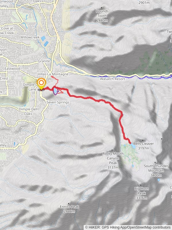
Bells Canyon Trail
Uinta-Wasatch-Cache National Forest · Salt Lake County, Utah
14.9 km
~1 day 0 hrs
1362 m
“Explore Bells Canyon Trail's 15 km hike in Utah, featuring stunning reservoirs, wildlife, and historical landmarks.”
Starting near Salt Lake County, Utah, the Bells Canyon Trail is a captivating out-and-back hike that stretches approximately 15 km (9.3 miles) with an elevation gain of around 1300 meters (4265 feet). This trail is rated as medium difficulty, making it suitable for moderately experienced hikers.### Getting There
To reach the trailhead, you can drive or use public transportation. If driving, head towards the Bells Canyon Granite Trailhead, located near 10245 Wasatch Blvd, Sandy, UT 84092. For those using public transport, the Utah Transit Authority (UTA) offers bus services that can drop you off near the trailhead. Check the UTA website for the latest schedules and routes.### Trail Overview
The trail begins at the Bells Canyon Granite Trailhead and quickly ascends through a series of switchbacks. Early on, you'll encounter the Lower Bells Canyon Reservoir, a serene spot perfect for a quick rest or photo opportunity. This reservoir is about 1.6 km (1 mile) from the trailhead and sits at an elevation of approximately 1,800 meters (5,905 feet).### Key Landmarks and Nature
As you continue, the trail becomes steeper and more rugged. Around the 4.8 km (3-mile) mark, you'll reach the Upper Bells Canyon Reservoir, which is a great place to take a longer break. This reservoir is nestled at an elevation of about 2,400 meters (7,874 feet) and offers stunning views of the surrounding peaks.Beyond the Upper Reservoir, the trail becomes more challenging, with rocky terrain and steeper inclines. This section is where you'll gain most of the remaining elevation. Keep an eye out for diverse wildlife, including deer, moose, and various bird species. The flora is equally impressive, with wildflowers blooming in the spring and summer months.### Historical Significance
Bells Canyon has a rich history, with evidence of Native American habitation and early pioneer activity. The canyon was named after the Bell family, early settlers in the area. As you hike, you may come across remnants of old mining operations, adding a historical layer to your adventure.### Navigation and Safety
Given the trail's varying terrain and elevation changes, it's advisable to use a reliable navigation tool like HiiKER to stay on course. The app provides detailed maps and real-time updates, ensuring you don't miss any critical turns or landmarks.### Final Stretch
The final stretch of the trail leads you to the Bells Canyon Waterfall, a stunning cascade that serves as the turnaround point for this out-and-back hike. The waterfall is located approximately 7.5 km (4.65 miles) from the trailhead and sits at an elevation of around 2,900 meters (9,514 feet). The sight and sound of the waterfall make the challenging ascent worthwhile.### Preparation Tips
Given the trail's length and elevation gain, it's essential to come prepared. Bring plenty of water, snacks, and layers of clothing to adapt to changing weather conditions. Good hiking boots are a must due to the rocky and uneven terrain. Always check the weather forecast before heading out, as conditions can change rapidly in the mountains.By following these guidelines and being well-prepared, you'll have a rewarding experience on the Bells Canyon Trail, enjoying its natural beauty and historical significance.
Reviews
User comments, reviews and discussions about the Bells Canyon Trail, Utah.
4.0
average rating out of 5
22 rating(s)
Loading reviews...


