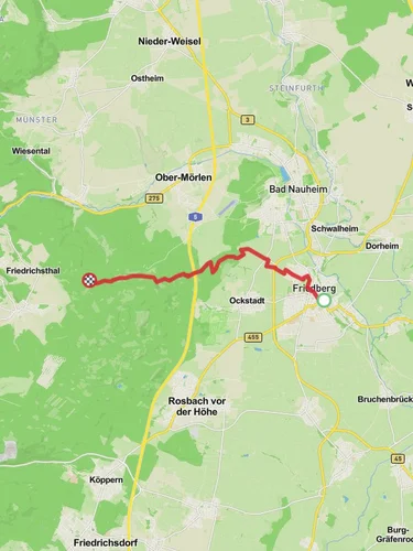
11.4 km
~2 hrs 45 min
290 m
“This 11 km loop trail near Wetteraukreis, Germany offers a rewarding mix of scenic views, moderate challenges, and historical intrigue.”
Starting near Wetteraukreis, Germany, this 11 km (approximately 6.8 miles) loop trail offers a moderate challenge with an elevation gain of around 200 meters (656 feet). The trailhead is easily accessible by car, with parking available near the starting point. For those using public transport, the nearest significant landmark is the town of Bad Nauheim, from where local buses can take you closer to the trailhead.
### Initial Ascent and Kellerberg
The hike begins with a gentle ascent through mixed forests, providing a serene start to your journey. As you make your way up Kellerberg, you'll notice the dense canopy of beech and oak trees, which offer ample shade. The initial climb is gradual, making it a good warm-up for the more challenging sections ahead. Keep an eye out for local wildlife such as deer and various bird species that inhabit this area.
### Großer Steinbruch
Around the 4 km (2.5 miles) mark, you'll reach Großer Steinbruch, an old quarry that offers a fascinating glimpse into the region's geological history. The quarry is a significant landmark, showcasing layers of sedimentary rock that tell the story of millions of years of Earth's history. This area is also a great spot for a short break, allowing you to take in the unique landscape and perhaps snap a few photos.
### Mainzer Kopf
Continuing on, the trail leads you to Mainzer Kopf, the highest point of the loop. This section involves a steeper climb, but the effort is well worth it. At an elevation of approximately 400 meters (1,312 feet), Mainzer Kopf offers panoramic views of the surrounding Wetterau region. On clear days, you can see as far as the Taunus mountain range. This is an excellent spot for a longer rest, where you can enjoy a packed lunch while taking in the breathtaking scenery.
### Descent and Return
The descent from Mainzer Kopf is more gradual, winding through lush meadows and open fields. This part of the trail is particularly beautiful in spring and summer when wildflowers are in full bloom. As you make your way back towards the trailhead, you'll pass through small patches of forest and open farmland, offering a diverse range of landscapes.
### Historical Significance
The Wetterau region is rich in history, with evidence of human settlement dating back to the Roman era. Along the trail, you may come across remnants of ancient Roman roads and boundary stones, adding a historical dimension to your hike. The area was also significant during the medieval period, with several castles and fortifications nearby, although not directly on the trail.
### Navigation and Safety
For navigation, it's highly recommended to use the HiiKER app, which provides detailed maps and real-time updates. The trail is well-marked, but having a reliable navigation tool will ensure you stay on track. Always carry sufficient water, especially during the warmer months, and wear appropriate footwear as some sections can be rocky and uneven.
This loop trail offers a perfect blend of natural beauty, moderate physical challenge, and historical intrigue, making it a rewarding experience for hikers of all levels.
Reviews
User comments, reviews and discussions about the Kellerberg, Großer Steinbruch and Mainzer Kopf Loop, Germany.
0.0
average rating out of 5
0 rating(s)


