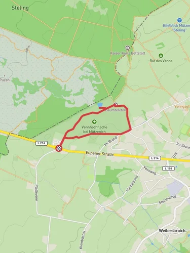
Venhochfläche bei Mützenich, Palsen, Hobbe and Hellenketel Loop
11.4 km
~2 hrs 28 min
113 m
“Explore lush forests, historic sites, and diverse wildlife on this scenic 11 km loop near Aachen.”
Starting near Städteregion Aachen in Germany, this 11 km (approximately 6.8 miles) loop trail offers a delightful mix of natural beauty and historical intrigue. With an elevation gain of around 100 meters (328 feet), the trail is rated as medium difficulty, making it accessible for most hikers with a moderate level of fitness.### Getting There
To reach the trailhead, you can drive or use public transport. If driving, set your GPS to Mützenich, a small village near the trailhead. For those using public transport, take a train to Aachen Hauptbahnhof and then a bus to Mützenich. The nearest significant landmark to the trailhead is the Mützenich Church, which is a good starting point for your hike.### Trail Overview
The Venhochfläche bei Mützenich, Palsen, Hobbe, and Hellenketel Loop takes you through a variety of landscapes, including dense forests, open meadows, and serene wetlands. The trail is well-marked, but it's always a good idea to have a navigation tool like HiiKER to ensure you stay on track.### Key Sections and Landmarks#### Mützenich to Palsen
Starting from Mützenich, the first section of the trail takes you through a lush forest. This part of the hike is relatively flat, making it a good warm-up. After about 2 km (1.2 miles), you'll reach the Palsen area, known for its picturesque meadows and small streams. Keep an eye out for local wildlife such as deer and various bird species.#### Palsen to Hobbe
Continuing from Palsen, the trail gradually ascends as you head towards Hobbe. This section is about 3 km (1.9 miles) long and offers some of the best views of the surrounding countryside. The elevation gain here is around 50 meters (164 feet), so take your time and enjoy the scenery. Hobbe is a great spot for a short break, with several benches and picnic areas available.#### Hobbe to Hellenketel
From Hobbe, the trail descends slightly as you make your way to Hellenketel. This 3 km (1.9 miles) stretch takes you through a mix of forest and open land. Hellenketel is known for its historical significance; during World War II, this area was part of the Siegfried Line, a series of defensive fortifications. You might come across some remnants of bunkers and trenches, adding a historical layer to your hike.#### Hellenketel to Mützenich
The final leg of the loop brings you back to Mützenich. This 3 km (1.9 miles) section is relatively flat and easy, making for a pleasant end to your hike. As you approach Mützenich, you'll pass through more meadows and small forests, offering a peaceful conclusion to your journey.### Flora and Fauna
The trail is rich in biodiversity. In the forested areas, you'll find a variety of trees including oak, beech, and pine. The meadows are home to wildflowers such as daisies and buttercups. Wildlife is abundant, with chances to see deer, foxes, and a variety of bird species including woodpeckers and owls.### Historical Significance
The region around Hellenketel holds historical importance due to its role in World War II. The Siegfried Line, also known as the Westwall, was a defensive line built by Germany. While most of the fortifications have been dismantled, some remnants still exist and serve as a poignant reminder of the past.### Preparation Tips
Given the moderate difficulty of the trail, it's advisable to wear sturdy hiking boots and bring plenty of water. The trail can be muddy in places, especially after rain, so waterproof gear is recommended. Always check the weather forecast before heading out and consider downloading the HiiKER app for real-time navigation and updates.This loop trail offers a perfect blend of natural beauty, wildlife, and historical significance, making it a rewarding experience for any hiker.
Reviews
User comments, reviews and discussions about the Venhochfläche bei Mützenich, Palsen, Hobbe and Hellenketel Loop, Germany.
5.0
average rating out of 5
7 rating(s)
Loading reviews...


