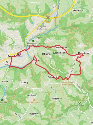
15.0 km
~3 hrs 41 min
407 m
“Explore lush landscapes, historic sites, and vibrant wildlife on this captivating Bergisches Land loop trail.”
Nestled in the picturesque region of Rheinisch-Bergischer Kreis, Germany, this 15 km (approximately 9.3 miles) loop trail offers a delightful blend of natural beauty and historical intrigue. With an elevation gain of around 400 meters (approximately 1,312 feet), this medium-difficulty hike is perfect for those looking to explore the serene landscapes of the Bergisches Land.### Getting ThereThe trailhead is conveniently located near the town of Rheinisch-Bergischer Kreis. For those traveling by public transport, the nearest major city is Cologne, from which you can take a regional train to Bergisch Gladbach. From there, local buses or a short taxi ride will bring you to the trailhead. If you're driving, the area is accessible via the A4 motorway, with ample parking available near the starting point.### Trail Highlights#### Scenic LandscapesAs you embark on this loop, you'll be greeted by the lush, rolling hills characteristic of the Bergisches Land. The trail meanders through dense forests, open meadows, and alongside tranquil streams, offering a diverse array of landscapes. Keep an eye out for the vibrant flora, especially during spring and summer when wildflowers are in full bloom.#### Historical SignificanceThe region is steeped in history, with remnants of its past visible along the trail. One notable landmark is the Altenberg Cathedral, a stunning example of Gothic architecture located a short detour from the main path. This cathedral, also known as the Bergischer Dom, dates back to the 13th century and is a testament to the area's rich cultural heritage.#### WildlifeThe trail is home to a variety of wildlife, including deer, foxes, and numerous bird species. Birdwatchers will particularly enjoy the opportunity to spot native species such as the European robin and the great tit. Early morning or late afternoon hikes increase your chances of encountering these creatures in their natural habitat.### Navigation and SafetyWhile the trail is well-marked, it's advisable to use the HiiKER app for navigation to ensure you stay on course. The app provides detailed maps and real-time updates, which can be particularly useful in the more remote sections of the trail. The terrain can be uneven and muddy, especially after rain, so sturdy hiking boots are recommended. Additionally, the elevation gain, though moderate, can be challenging for those not accustomed to hiking, so pace yourself and take breaks as needed.### Points of InterestAbout halfway through the trail, you'll come across the Dhünntalsperre, a large reservoir that offers stunning views and a peaceful spot for a picnic. The reservoir is a crucial water source for the region and is surrounded by a network of smaller trails for those looking to extend their hike.As you near the end of the loop, the trail passes through several charming villages, where you can experience local hospitality and perhaps enjoy a traditional German meal. These villages often host small markets and festivals, providing a glimpse into the local culture and traditions.This trail offers a perfect blend of nature, history, and culture, making it a rewarding experience for hikers of all levels. Whether you're drawn by the scenic beauty, the historical landmarks, or the chance to spot wildlife, this loop trail in the heart of Germany's Bergisches Land promises an unforgettable adventure.
Reviews
User comments, reviews and discussions about the Bergischer Weg, Rundweg A3 and Kurkoelner Weg, Germany.
5.0
average rating out of 5
1 rating(s)
Loading reviews...


