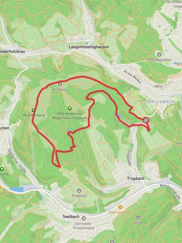
Huettentaler Rundweg and Langenholdinghausener Rundweg
7.6 km
~1 hrs 46 min
149 m
“Experience a rewarding 8 km hike through lush forests, historical landmarks, and stunning countryside views.”
Starting near Kreis Siegen-Wittgenstein, Germany, the Huettentaler Rundweg and Langenholdinghausener Rundweg is an 8 km (approximately 5 miles) loop trail with an elevation gain of around 100 meters (328 feet). This medium-difficulty trail offers a delightful mix of natural beauty and historical significance, making it a rewarding experience for hikers.
### Getting There To reach the trailhead, you can drive or use public transport. If driving, set your GPS to Kreis Siegen-Wittgenstein, Germany. For those using public transport, the nearest significant landmark is the Siegen Hauptbahnhof (Siegen Main Station). From there, you can take a local bus or taxi to the trailhead.
### Trail Navigation For navigation, it's highly recommended to use the HiiKER app, which provides detailed maps and real-time updates to ensure you stay on track.
### Trail Highlights The trail begins with a gentle ascent through lush forests, where you can enjoy the serene ambiance and the sound of birds chirping. After about 1 km (0.6 miles), you'll reach a small clearing that offers a panoramic view of the surrounding countryside. This is an excellent spot for a quick rest and some photos.
### Historical Significance As you continue, you'll come across several historical landmarks. Around the 3 km (1.9 miles) mark, you'll find the remnants of an old watchtower. This tower dates back to the medieval period and was part of the region's defense system. Information plaques provide insights into its history and significance.
### Flora and Fauna The trail is rich in biodiversity. You'll encounter a variety of trees, including oak, beech, and pine. In the spring and summer months, the forest floor is carpeted with wildflowers, adding a splash of color to your hike. Wildlife is abundant, with chances to spot deer, foxes, and a variety of bird species.
### Midpoint and Elevation At around the 4 km (2.5 miles) mark, you'll reach the highest point of the trail, approximately 100 meters (328 feet) above the starting elevation. This section offers stunning views of the Siegen-Wittgenstein region. It's a great place to take a break and enjoy a snack.
### Descending and Looping Back The descent begins gradually, leading you through more dense forest areas. Around the 6 km (3.7 miles) mark, you'll pass by a picturesque stream. The sound of flowing water adds to the tranquility of the hike. Keep an eye out for small wooden bridges that cross the stream, adding a charming touch to the trail.
### Final Stretch As you approach the final 2 km (1.2 miles), the trail loops back towards the starting point. This section is relatively flat and easy, allowing you to cool down and reflect on the hike. You'll pass through open meadows, which are particularly beautiful in the late afternoon light.
### Practical Tips - Wear sturdy hiking boots, as some sections can be muddy, especially after rain. - Bring enough water and snacks, as there are no facilities along the trail. - Check the weather forecast before heading out, as conditions can change rapidly.
This trail offers a perfect blend of natural beauty, historical intrigue, and moderate physical challenge, making it a must-visit for any hiking enthusiast.
Reviews
User comments, reviews and discussions about the Huettentaler Rundweg and Langenholdinghausener Rundweg, Germany.
0.0
average rating out of 5
0 rating(s)


