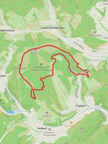
9.5 km
~2 hrs 17 min
236 m
“Explore a 10 km scenic loop in Siegen-Wittgenstein, featuring serene forests, historic sites, and panoramic views.”
Starting near Kreis Siegen-Wittgenstein in Germany, this 10 km (6.2 miles) loop trail offers a moderate challenge with an elevation gain of around 200 meters (656 feet). The trailhead is easily accessible by car, with parking available nearby. For those using public transport, the nearest significant landmark is the Siegen train station, from where local buses can take you closer to the trailhead.
### Initial Ascent and Forested Pathways The trail begins with a gentle ascent through dense forest, providing a serene start to your hike. The first 2 km (1.2 miles) will see you gaining about 50 meters (164 feet) in elevation. The forest is home to a variety of wildlife, including deer and numerous bird species, so keep your eyes and ears open. The path is well-marked, but it's advisable to use HiiKER for navigation to ensure you stay on track.
### Heesbach Stream and Scenic Views Around the 3 km (1.9 miles) mark, you'll encounter the Heesbach stream. This is a great spot to take a short break and enjoy the tranquil sounds of flowing water. The trail follows the stream for a short distance before beginning a steeper ascent. Over the next 2 km (1.2 miles), you'll gain another 100 meters (328 feet) in elevation. This section offers some of the most scenic views of the surrounding countryside, so have your camera ready.
### Historical Significance As you continue, you'll come across remnants of old mining operations, a nod to the region's rich industrial history. The Siegen-Wittgenstein area was historically significant for its iron ore mining, which dates back to the Roman era. Informational plaques along the trail provide insights into this fascinating past.
### Huettentaler Rundweg Loop At approximately the 6 km (3.7 miles) mark, you'll reach the highest point of the trail. From here, the path loops back towards the starting point. The descent is gradual, allowing you to enjoy the lush greenery and occasional clearings that offer panoramic views of the valley below. This section is particularly beautiful in the autumn when the foliage turns vibrant shades of red and gold.
### Final Stretch and Return The last 2 km (1.2 miles) of the trail are relatively flat, making for an easy and relaxing end to your hike. You'll pass through a mix of forest and open fields, with the occasional bench where you can sit and take in the scenery. The trail eventually leads you back to the starting point near Kreis Siegen-Wittgenstein.
### Practical Information Ensure you have sturdy hiking boots, as some sections can be rocky and uneven. Carry enough water and snacks, especially if you plan to take your time exploring the historical sites and enjoying the natural beauty. The trail is well-marked, but having HiiKER on your device will provide additional peace of mind.
Reviews
User comments, reviews and discussions about the Huettentaler Rundweg and Heesbach, Germany.
0.0
average rating out of 5
0 rating(s)


