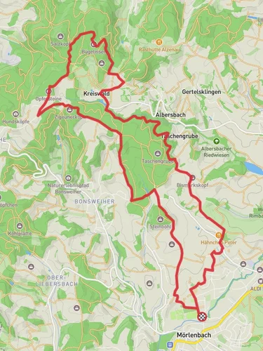
9.4 km
~2 hrs 17 min
245 m
“Explore Germany's scenic Odenwald on a 9 km trail rich in nature and history.”
Starting near Kreis Bergstraße in Germany, the Solardraisinen Wanderweg and Moerlenbach trail offers a delightful 9 km (5.6 miles) loop with an elevation gain of approximately 200 meters (656 feet). This medium-difficulty trail is perfect for those looking to explore the scenic beauty and historical richness of the region.
### Getting There To reach the trailhead, you can drive or use public transport. If driving, set your GPS to Kreis Bergstraße, Germany. For public transport, take a train to the nearest station in Mörlenbach, which is well-connected to major cities like Frankfurt and Heidelberg. From the station, it's a short walk to the trailhead.
### Trail Navigation For navigation, HiiKER is highly recommended. The app provides detailed maps and real-time updates, ensuring you stay on the right path.
### Trail Highlights
#### Scenic Views and Nature The trail meanders through lush forests and open meadows, offering stunning views of the Odenwald region. Early in the hike, you'll encounter dense woodlands filled with oak and beech trees. As you ascend, the forest opens up to reveal panoramic vistas of the surrounding hills and valleys. Keep an eye out for local wildlife, including deer, foxes, and a variety of bird species.
#### Historical Significance The region is steeped in history, with several landmarks along the way. About 3 km (1.9 miles) into the hike, you'll come across the ruins of an old watchtower, a remnant from the medieval period when the area was a strategic point for local lords. Further along, at around the 6 km (3.7 miles) mark, you'll find a small chapel dating back to the 17th century, offering a peaceful spot for rest and reflection.
### Key Sections of the Trail
#### Initial Ascent The first 2 km (1.2 miles) involve a gradual ascent through the forest, gaining about 100 meters (328 feet) in elevation. This section can be a bit challenging due to the uneven terrain, so sturdy hiking boots are recommended.
#### Mid-Trail Meadows Around the 4 km (2.5 miles) point, the trail levels out and passes through open meadows. This is a great spot for a picnic, with several benches and tables available. The meadows are particularly beautiful in spring and summer when wildflowers are in full bloom.
#### Final Descent The last 3 km (1.9 miles) involve a gentle descent back towards the trailhead. This section is less strenuous and offers more opportunities to enjoy the surrounding scenery. Be cautious of loose gravel on the path, especially after rain.
### Practical Tips - Water and Snacks: There are no facilities along the trail, so bring enough water and snacks for the entire hike. - Weather: The trail can be muddy after rain, so check the weather forecast and dress accordingly. - Wildlife: While encounters with wildlife are generally safe, it's advisable to keep a respectful distance and avoid feeding animals.
This trail offers a perfect blend of natural beauty and historical intrigue, making it a rewarding experience for hikers of all levels.
Reviews
User comments, reviews and discussions about the Solardraisinen Wanderweg and Moerlenbach, Germany.
0.0
average rating out of 5
0 rating(s)


