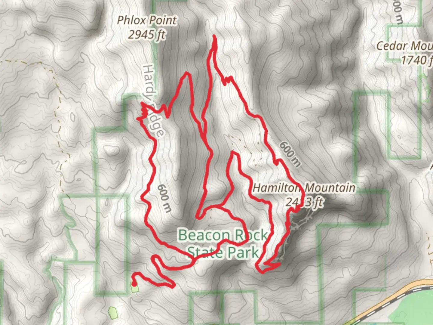
Hardy Ridge, Hardy Creek and Hamilton Mountain Loop Trail
Download
Preview
Add to list
More
22.3 km
~1 day 1 hrs
1387 m
Loop
“This captivating 22 km loop trail offers panoramic views, diverse landscapes, and moderate challenges for experienced hikers.”
Starting near Skamania County, Washington, the Hardy Ridge, Hardy Creek, and Hamilton Mountain Loop Trail is a captivating 22 km (approximately 13.7 miles) loop with an elevation gain of around 1300 meters (4265 feet). This trail offers a medium difficulty rating, making it suitable for moderately experienced hikers.### Getting There To reach the trailhead, you can drive or use public transport. If driving, head towards Beacon Rock State Park, located off State Route 14. The nearest significant landmark is Beacon Rock, a prominent monolith that is hard to miss. For those using public transport, the nearest major city is Portland, Oregon. From Portland, you can take a bus to Cascade Locks and then a taxi or rideshare service to Beacon Rock State Park.### Trail Overview The loop begins with a gradual ascent through dense forest, where you'll be surrounded by towering Douglas firs and western red cedars. The first section of the trail follows Hardy Creek, offering a serene environment with the gentle sound of flowing water. After about 3 km (1.9 miles), you'll reach a junction where the trail splits; taking the left fork will lead you towards Hardy Ridge.### Hardy Ridge As you ascend Hardy Ridge, the trail becomes steeper, gaining approximately 600 meters (1968 feet) in elevation over the next 5 km (3.1 miles). This section is known for its panoramic views of the Columbia River Gorge. On clear days, you can see Mount Hood to the south and Mount Adams to the north. The ridge is also a great spot for wildflower viewing in the spring and early summer, with lupines, Indian paintbrush, and beargrass in full bloom.### Hardy Creek Descending from Hardy Ridge, you'll reconnect with Hardy Creek. This section of the trail is less strenuous, allowing you to enjoy the lush greenery and occasional wildlife sightings. Keep an eye out for black-tailed deer and various bird species, including woodpeckers and owls. The trail follows the creek for another 4 km (2.5 miles) before reaching another junction.### Hamilton Mountain The final leg of the loop takes you up Hamilton Mountain, adding another 700 meters (2297 feet) of elevation gain over 6 km (3.7 miles). This section is more challenging, with steep switchbacks and rocky terrain. However, the effort is well worth it. At the summit, you'll be rewarded with breathtaking views of the Columbia River, Bonneville Dam, and the surrounding Cascade Range. The summit area also features several basalt rock formations, remnants of ancient volcanic activity.### Historical Significance The Columbia River Gorge has a rich history, having been a vital trade route for Native American tribes for thousands of years. The area around Beacon Rock was explored by the Lewis and Clark Expedition in 1805, and the rock itself was named by William Clark. The Bonneville Dam, visible from Hamilton Mountain, was completed in 1938 and is a significant engineering feat, providing hydroelectric power and aiding in river navigation.### Navigation and Safety Given the trail's length and elevation gain, it's crucial to be well-prepared. Use the HiiKER app for accurate navigation and real-time updates on trail conditions. Carry sufficient water, snacks, and a first-aid kit. Weather can change rapidly in the gorge, so pack layers and be prepared for rain, even in summer. This loop trail offers a diverse hiking experience, from serene creekside paths to challenging mountain ascents, all set against the backdrop of the stunning Columbia River Gorge.

What to expect?
Activity types
Comments and Reviews
User comments, reviews and discussions about the Hardy Ridge, Hardy Creek and Hamilton Mountain Loop Trail, Washington.
4.5
average rating out of 5
16 rating(s)