Download
Preview
Add to list
More
10.3 km
~3 hrs 48 min
1056 m
Out and Back
“Embark on a scenic, moderately challenging 10-kilometer hike with stunning vistas, diverse flora, and rich history.”
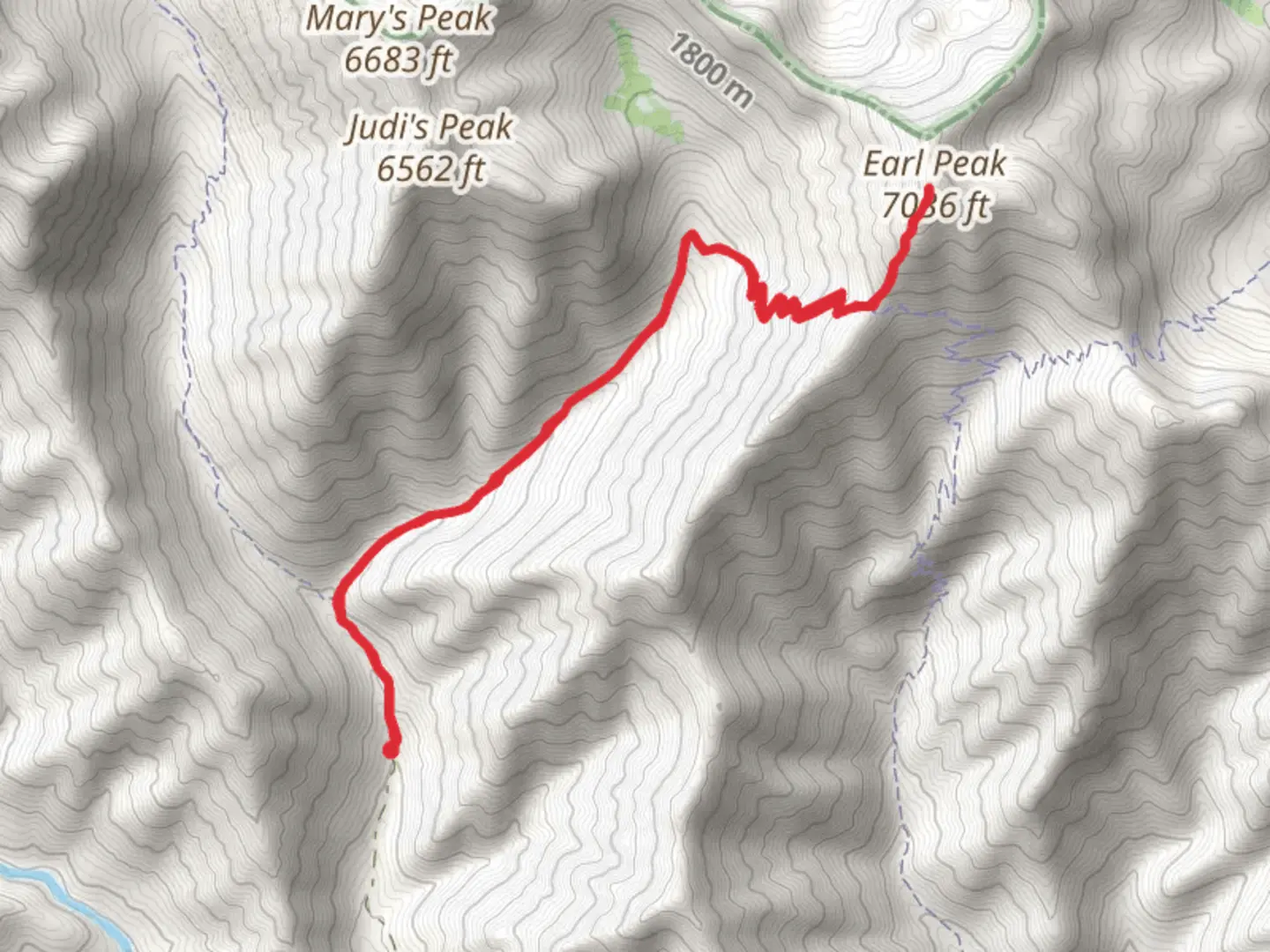
Starting your hike near Kittitas County, Washington, the trailhead for Earl Peak via Bean Creek Trail is accessible by car. From Seattle, it's about a 2-hour drive east on I-90. Take exit 85 toward WA-970 N, then follow signs for Teanaway Road. Continue on Teanaway Road until you reach the Bean Creek Trailhead parking area. Public transport options are limited, so driving is recommended.The trail spans approximately 10 kilometers (6.2 miles) round trip, with an elevation gain of around 1000 meters (3280 feet). This out-and-back trail is rated as medium difficulty, making it suitable for moderately experienced hikers.### Initial Ascent and Bean Creek Crossing Starting from the trailhead, the first section of the hike involves a gradual ascent through a dense forest of pine and fir trees. After about 1.5 kilometers (0.9 miles), you'll reach Bean Creek. Depending on the season, the creek can be a gentle stream or a more challenging crossing, so be prepared with waterproof boots or sandals. ### Climbing Through Meadows Once you cross Bean Creek, the trail begins to climb more steeply. Around the 3-kilometer (1.9-mile) mark, you'll emerge from the forest into open meadows. These meadows are particularly stunning in late spring and early summer when wildflowers like lupine, Indian paintbrush, and columbine are in full bloom. Keep an eye out for marmots and deer, which are commonly seen in this area.### Switchbacks and Ridge Line As you continue, the trail becomes steeper and more rugged, with a series of switchbacks leading you up to the ridge line. This section covers approximately 2 kilometers (1.2 miles) and gains significant elevation. The views start to open up, offering panoramic vistas of the surrounding peaks and valleys. ### Final Push to Earl Peak The last stretch to Earl Peak involves a rocky scramble. This section is about 1 kilometer (0.6 miles) and requires careful footing. The summit offers breathtaking 360-degree views, including sights of Mount Stuart and the Enchantments to the west. ### Historical Significance The region around Earl Peak has a rich history tied to the indigenous Yakama Nation, who have lived in the area for thousands of years. The Teanaway area was also a significant site during the early 20th century for logging and mining activities, remnants of which can still be seen along the trail.### Navigation and Safety Given the elevation gain and the rugged terrain, it's advisable to use a reliable navigation tool like HiiKER to stay on track. Weather can change rapidly in the mountains, so pack layers and be prepared for sudden shifts in temperature and conditions. ### Return Journey After soaking in the views and perhaps enjoying a well-deserved snack, retrace your steps back down the trail. The descent offers a different perspective and another chance to appreciate the diverse flora and fauna of the region.This hike is a rewarding adventure that combines natural beauty, physical challenge, and a touch of historical intrigue, making it a must-do for any hiking enthusiast in Washington.

What to expect?
Activity types
Comments and Reviews
User comments, reviews and discussions about the Earl Peak via Bean Creek Trail, Washington.
4.65
average rating out of 5
17 rating(s)