Download
Preview
Add to list
More
9.0 km
~2 hrs 35 min
471 m
Loop
“Wild headlands, blooming heath, and echoes of history create a vibrant coastal adventure near Rhiw.”
Starting from the small car park near the village of Rhiw, close to the tip of the Llŷn Peninsula in Gwynedd, Wales, this 9 km (about 5.6 miles) loop offers a blend of coastal drama, wild headlands, and rich local history. The trailhead is easily accessible by car, with parking available at the end of the minor road leading from Rhiw. For those using public transport, buses from Pwllheli serve Aberdaron, from where a short taxi ride or a longer walk brings you to the starting point.
Initial Ascent and Coastal Views
The route begins with a steady climb, gaining around 500 metres (1,640 feet) of elevation over the course of the loop. Early on, the path rises up the slopes of Mynydd Mawr, a prominent hill offering panoramic views across Cardigan Bay and towards Bardsey Island. The ascent is grassy but can be boggy after rain, so waterproof boots are recommended. As you crest the summit, look out for the old World War II lookout post, a reminder of the area’s strategic importance during the conflict.
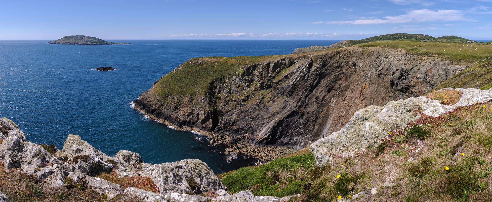
Pen y Cil Headland and Wildlife
Descending from Mynydd Mawr, the trail skirts the dramatic cliffs of Pen y Cil. This headland is a haven for seabirds, including choughs, razorbills, and occasionally peregrine falcons. The coastal heathland here bursts with wildflowers in late spring and summer, attracting butterflies and bees. The path can be narrow and exposed in places, with steep drops to one side, so caution is advised, especially in windy conditions.
Porth Meudwy and Historical Significance
At roughly the halfway point, the trail drops down to Porth Meudwy, a sheltered cove historically used by fishermen and as the embarkation point for pilgrims heading to Bardsey Island. The small stone quay and fishermen’s huts evoke centuries of maritime tradition. This spot is ideal for a rest, with the chance to spot seals basking on the rocks or watch lobster boats returning with their catch.
Return via Coastal Path
The return leg follows the Wales Coast Path, undulating along the clifftops with sweeping views back towards Mynydd Mawr and the open sea. The path is well-marked but can be muddy and uneven, so sturdy footwear is essential. Hikers should be prepared for changeable weather, as sea fog and strong winds are common even in summer.
Navigation and Safety
Navigation is straightforward with the HiiKER app, which provides detailed mapping and real-time GPS tracking for this loop. Mobile signal can be patchy, so downloading the route in advance is recommended. There are no facilities along the trail, so bring sufficient water and snacks, and be prepared for limited shelter from the elements.
This loop is a rewarding hike for those seeking a mix of natural beauty, wildlife, and a sense of the region’s deep-rooted history, all within a manageable distance and elevation profile.

What to expect?
Activity types
Comments and Reviews
User comments, reviews and discussions about the Pen y Cil and Porth Meudwy from Mynydd Mawr, Wales.
4.51
average rating out of 5
37 rating(s)