Download
Preview
Add to list
More
4.6 km
~1 hrs 33 min
383 m
Out and Back
“Experience the serene beauty and historical richness of the medium-difficulty Woodland Hills Switchback Trail in Utah.”
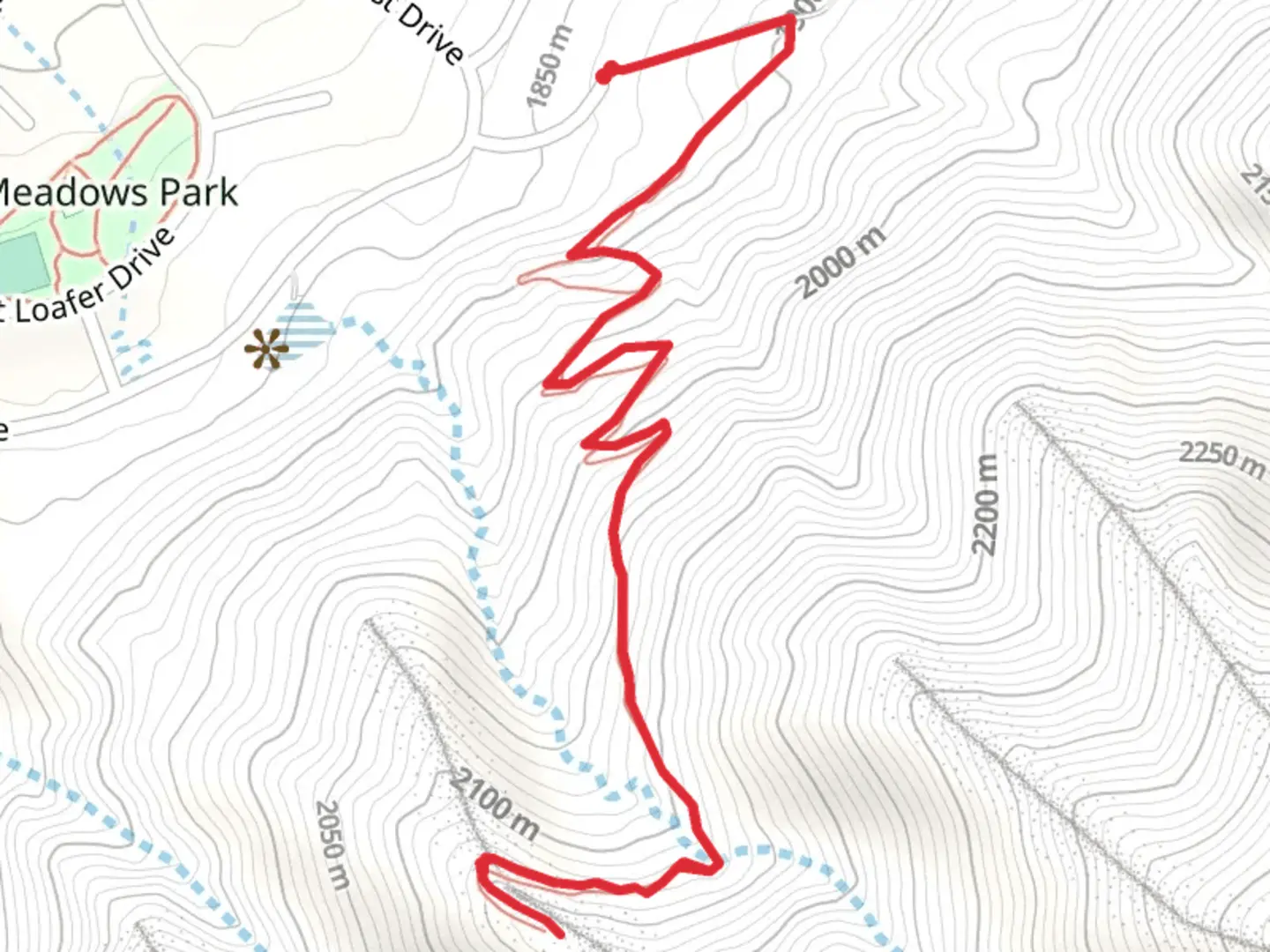
Starting your adventure near Utah County, Utah, the Woodland Hills Switchback Trail offers a delightful 5 km (approximately 3.1 miles) out-and-back journey with an elevation gain of around 300 meters (984 feet). This medium-difficulty trail is perfect for those looking to challenge themselves while enjoying the serene beauty of the area.### Getting There To reach the trailhead, you can drive or use public transportation. If driving, head towards Woodland Hills Drive, Woodland Hills, UT 84653. For those relying on public transport, the nearest major transit hub is in Provo, Utah. From Provo, you can take a local bus or a rideshare service to Woodland Hills Drive. The trailhead is conveniently located near the end of this road, making it easily accessible.### Trail Navigation and Terrain The Woodland Hills Switchback Trail is well-marked and can be navigated using the HiiKER app, which provides detailed maps and real-time updates. The trail begins with a gentle ascent through a mixed forest of pine and aspen trees. As you progress, the switchbacks become more pronounced, offering a steady climb that will get your heart pumping.### Flora and Fauna Keep an eye out for the diverse wildlife that inhabits this region. Deer are commonly spotted along the trail, and if you're lucky, you might even see a fox or a variety of bird species, including hawks and woodpeckers. The flora is equally impressive, with wildflowers blooming in the spring and summer months, adding a splash of color to your hike.### Significant Landmarks At approximately 1.5 km (0.93 miles) into the hike, you'll come across a small, picturesque stream. This is a great spot to take a short break and enjoy the soothing sounds of flowing water. Continuing on, the trail offers several viewpoints where you can catch your breath and take in the stunning vistas of Utah Valley and the surrounding mountains.### Historical Significance The Woodland Hills area has a rich history, with Native American tribes such as the Ute and Shoshone having inhabited the region for centuries. Artifacts and remnants of their presence can sometimes be found near the trail, adding a layer of historical intrigue to your hike. Additionally, the trail was used by early settlers and pioneers as a route through the mountains, making it a path steeped in history.### Final Stretch As you near the 2.5 km (1.55 miles) mark, the trail reaches its highest point, offering panoramic views that are well worth the climb. This is the perfect spot to take a moment, snap some photos, and appreciate the natural beauty that surrounds you. The descent follows the same path, allowing you to enjoy the scenery from a different perspective on your way back.### Preparation Tips Given the elevation gain and the switchbacks, it's advisable to wear sturdy hiking boots and bring plenty of water. The trail can be quite exposed in certain sections, so sunscreen and a hat are recommended. Always check the weather forecast before heading out, as conditions can change rapidly in the mountains.By following these guidelines and using the HiiKER app for navigation, you'll be well-prepared to enjoy the Woodland Hills Switchback Trail to its fullest.

What to expect?
Activity types
Comments and Reviews
User comments, reviews and discussions about the Woodland Hills Switchback Trail, Utah.
4.53
average rating out of 5
15 rating(s)