Download
Preview
Add to list
More
5.7 km
~1 hrs 30 min
228 m
Loop
“Embark on the Moonlight Meadows Trail for a scenic, moderately challenging hike rich in wildlife and history.”
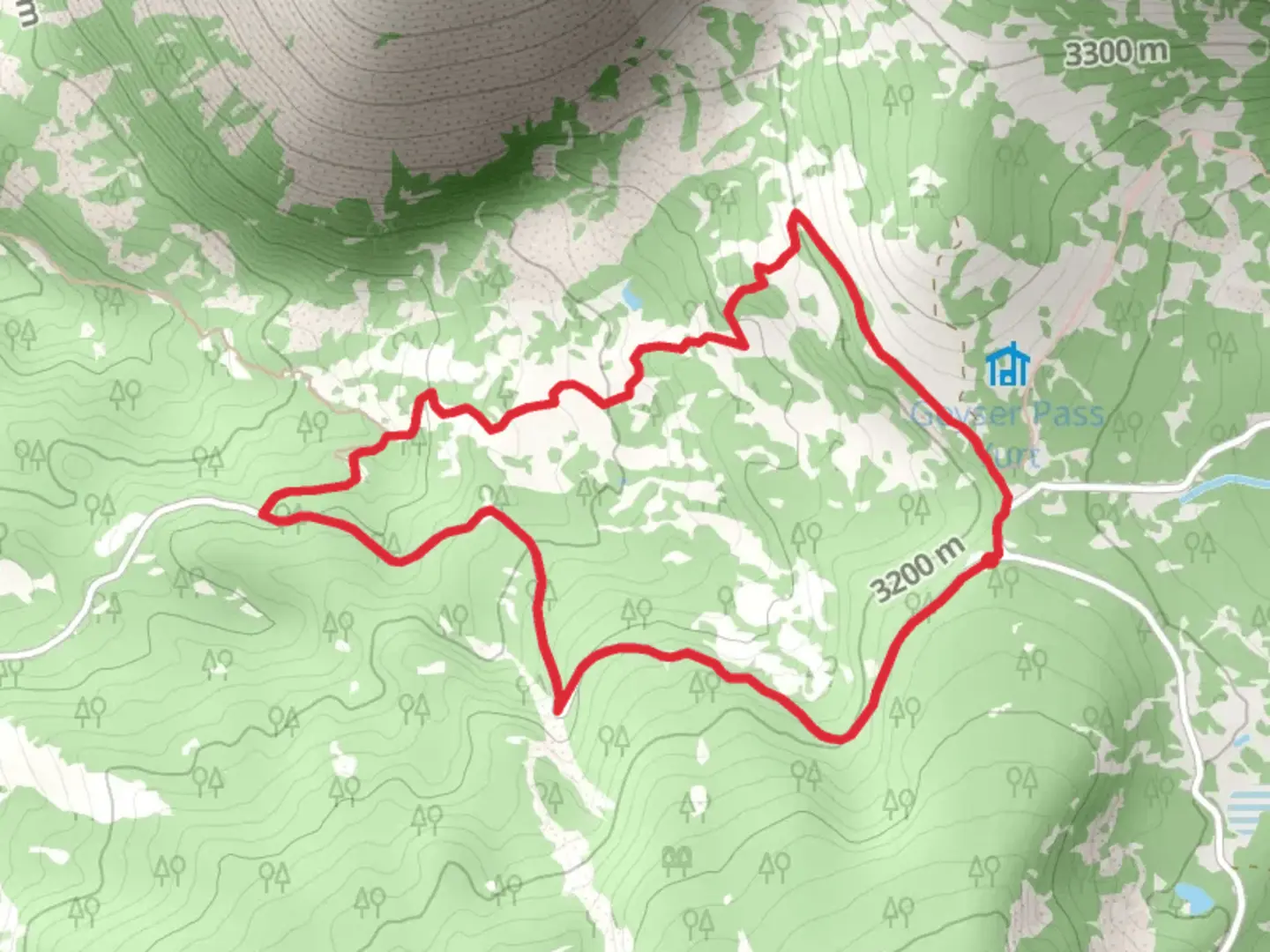
Starting your adventure near San Juan County, Utah, the Moonlight Meadows Trail and Geyser Pass Road Loop offers a captivating 6 km (approximately 3.7 miles) journey with an elevation gain of around 200 meters (656 feet). This loop trail is rated as medium difficulty, making it suitable for moderately experienced hikers.### Getting ThereTo reach the trailhead, you can drive or use public transportation. If driving, head towards the La Sal Mountains, and the nearest significant landmark is the Geyser Pass Trailhead. For those using public transport, the closest major town is Moab, Utah. From Moab, you can take a shuttle service or a taxi to the trailhead, which is approximately a 45-minute drive.### Trail OverviewThe trail begins at the Geyser Pass Trailhead, located at an elevation of about 3,200 meters (10,500 feet). The initial section of the trail meanders through dense forests of aspen and pine, offering a serene and shaded start to your hike. As you progress, the trail opens up into Moonlight Meadows, a picturesque expanse filled with wildflowers during the spring and summer months.### Key Landmarks and Points of Interest- Moonlight Meadows: At approximately 1.5 km (0.9 miles) into the hike, you'll reach Moonlight Meadows. This area is known for its vibrant display of wildflowers, including lupines, Indian paintbrush, and columbines. The meadows also provide excellent opportunities for birdwatching, with species such as the Mountain Bluebird and the Western Tanager frequently spotted.- Geyser Pass Road: Around the 3 km (1.8 miles) mark, the trail intersects with Geyser Pass Road. This section of the trail offers panoramic views of the La Sal Mountains and the surrounding valleys. The road itself is a historical route used by early settlers and miners in the region.- Historical Significance: The La Sal Mountains have a rich history, with evidence of Native American habitation dating back thousands of years. The area was also explored by Spanish missionaries in the 18th century, and later by American pioneers and miners in the 19th century. Keep an eye out for old mining equipment and remnants of cabins along the trail.### Wildlife and NatureThe trail is home to a diverse array of wildlife. Mule deer, elk, and even black bears can occasionally be seen, especially during the early morning or late evening hours. Smaller mammals such as marmots and pikas are also common. The trail's high elevation and varied ecosystems make it a haven for a wide range of plant and animal species.### Navigation and SafetyGiven the trail's moderate difficulty, it's essential to come prepared. The trail is well-marked, but carrying a reliable navigation tool like HiiKER is recommended to ensure you stay on course. Weather in the La Sal Mountains can be unpredictable, so pack layers and be prepared for sudden changes in temperature. Additionally, the high elevation can cause altitude sickness, so take your time and stay hydrated.### Final StretchThe final section of the loop descends back through the forest, offering a gentle and scenic end to your hike. As you approach the trailhead, take a moment to enjoy the tranquility of the surroundings and reflect on the natural beauty and historical significance of the area.This trail offers a perfect blend of natural beauty, wildlife, and historical intrigue, making it a must-visit for any hiking enthusiast exploring the La Sal Mountains.

What to expect?
Activity types
Comments and Reviews
User comments, reviews and discussions about the Moonlight Meadows Trail and Geyser Pass Road Loop, Utah.
4.57
average rating out of 5
7 rating(s)