Download
Preview
Add to list
More
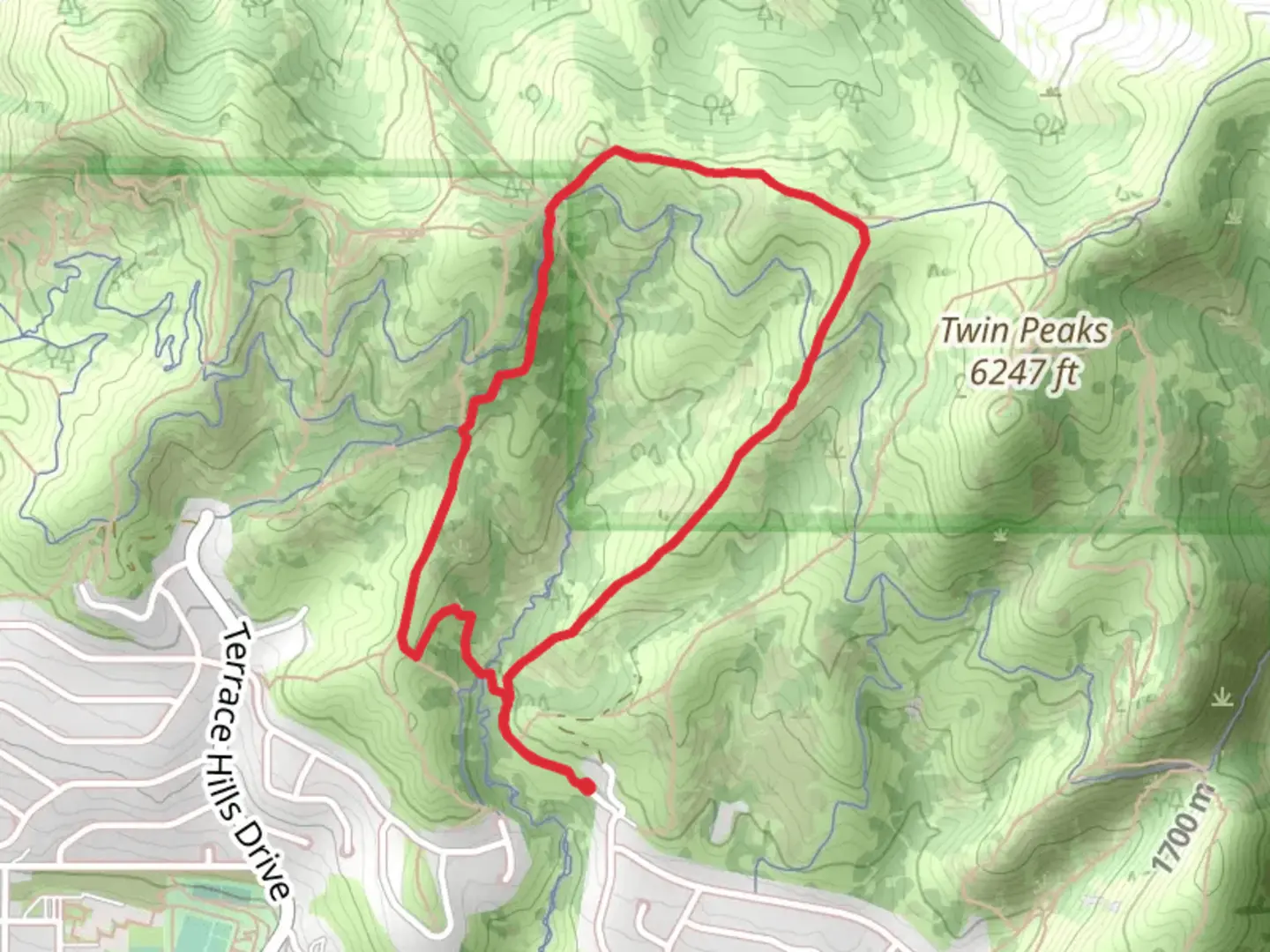
4.5 km
~1 hrs 22 min
281 m
Loop
“Discover panoramic views, rich biodiversity, and historic sites on the moderately challenging Twin Peaks Connect Loop.”
Starting near Salt Lake County, Utah, the Twin Peaks Connect Loop is a scenic 5 km (approximately 3.1 miles) loop trail with an elevation gain of around 200 meters (656 feet). This trail offers a moderate challenge, making it suitable for hikers with some experience. ### Getting There To reach the trailhead, you can drive or use public transportation. If driving, head towards the nearest known landmark, the Big Cottonwood Canyon Park & Ride, located at 6450 S Wasatch Blvd, Holladay, UT 84121. From there, it's a short drive to the trailhead. For those using public transport, take a bus to the Big Cottonwood Canyon Park & Ride and then arrange for a short taxi or rideshare to the trailhead.### Trail Overview The trail begins with a gentle ascent through a mixed forest of pine and aspen trees. Early on, you'll encounter a small stream, which is a great spot to refill your water bottles if you have a filtration system. The first kilometer (0.6 miles) is relatively easy, with a gradual elevation gain of about 50 meters (164 feet).### Key Landmarks and Points of Interest As you continue, the trail becomes steeper, gaining another 100 meters (328 feet) over the next 1.5 kilometers (0.9 miles). At this point, you'll reach a scenic overlook that offers panoramic views of the Salt Lake Valley and the surrounding Wasatch Mountains. This is a perfect spot for a short break and some photos.Around the 3 km (1.9 miles) mark, you'll come across a historical marker indicating the site of an old mining operation from the late 19th century. This area was once bustling with activity during Utah's mining boom, and you can still see remnants of old mining equipment and structures.### Flora and Fauna The trail is rich in biodiversity. In the spring and summer months, you'll find a variety of wildflowers, including Indian paintbrush and columbine. Keep an eye out for local wildlife such as mule deer, red foxes, and a variety of bird species including hawks and woodpeckers. ### Navigation and Safety The trail is well-marked, but it's always a good idea to have a reliable navigation tool. HiiKER is an excellent app for this purpose, providing detailed maps and real-time location tracking. Make sure to wear sturdy hiking boots, as some sections of the trail can be rocky and uneven. ### Final Stretch The last 1.5 kilometers (0.9 miles) of the trail loop back towards the starting point, descending gradually through a dense forest. This section is less strenuous, allowing you to enjoy the serene environment and perhaps spot some more wildlife.### Weather and Best Time to Hike The best time to hike the Twin Peaks Connect Loop is from late spring to early fall. During these months, the weather is generally mild, and the trail is free of snow. However, always check the weather forecast before heading out, as conditions can change rapidly in the mountains.By following these guidelines and being well-prepared, you'll have an enjoyable and memorable hike on the Twin Peaks Connect Loop.

What to expect?
Activity types
Comments and Reviews
User comments, reviews and discussions about the Twin Peaks Connect Loop, Utah.
4.53
average rating out of 5
15 rating(s)