Download
Preview
Add to list
More
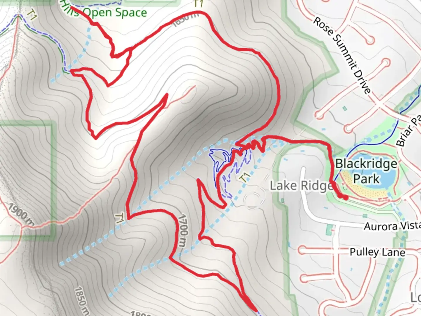
6.1 km
~1 hrs 40 min
275 m
Loop
“Embark on a scenic, moderately challenging 6 km loop near Salt Lake County, rich in diverse landscapes and history.”
Starting near Salt Lake County, Utah, the Blackridge Trail, Diamond Trail, and Sidewinder Loop offer a rewarding 6 km (approximately 3.7 miles) loop with an elevation gain of around 200 meters (656 feet). This medium-difficulty trail is perfect for hikers looking for a moderately challenging adventure with diverse scenery and notable landmarks.### Getting There To reach the trailhead, you can drive or use public transportation. If driving, head towards Blackridge Reservoir, located at 15000 S Ashland Ridge Dr, Herriman, UT 84096. There is ample parking available near the reservoir. For those using public transport, take the UTA bus service to the Herriman area and get off at the nearest stop to Blackridge Reservoir. From there, it's a short walk to the trailhead.### Trail Overview The loop begins at the Blackridge Reservoir, a popular spot for locals to enjoy water activities and picnics. As you start your hike, you'll quickly ascend into the foothills, offering panoramic views of the Salt Lake Valley. The initial climb is steady but manageable, gaining about 100 meters (328 feet) in the first 1.5 km (0.93 miles).### Key Sections and Landmarks
Blackridge Trail
The Blackridge Trail section is characterized by its well-maintained path and gradual ascent. You'll pass through a mix of scrub oak and sagebrush, typical of the region's high desert environment. Keep an eye out for mule deer and various bird species, including hawks and songbirds.#### Diamond Trail Transitioning onto the Diamond Trail, the terrain becomes slightly more rugged. This section is known for its rocky outcrops and occasional steep inclines. Around the 3 km (1.86 miles) mark, you'll reach the highest point of the loop, offering stunning views of the Oquirrh Mountains to the west and the Wasatch Range to the east. This is a great spot to take a break and soak in the scenery.#### Sidewinder Loop The Sidewinder Loop brings you back down towards the reservoir, with a series of switchbacks that make the descent more gradual. This part of the trail is particularly scenic in the spring and early summer when wildflowers like Indian paintbrush and lupine are in bloom. The descent covers the remaining 100 meters (328 feet) of elevation loss over the last 2.5 km (1.55 miles).### Historical Significance The area around Salt Lake County has a rich history, with evidence of Native American habitation dating back thousands of years. The trails themselves were used by early settlers and pioneers as they explored the region. The nearby Oquirrh Mountains were significant for mining activities in the 19th century, contributing to the development of the surrounding communities.### Navigation and Safety For navigation, it's recommended to use the HiiKER app, which provides detailed maps and real-time GPS tracking to ensure you stay on course. The trail is well-marked, but having a reliable navigation tool can enhance your hiking experience and safety.### Wildlife and Flora The trail offers a chance to see a variety of wildlife, including mule deer, rabbits, and occasionally coyotes. Birdwatchers will appreciate the diversity of species, from raptors to smaller songbirds. The flora is equally diverse, with sagebrush, scrub oak, and wildflowers providing a colorful backdrop, especially in the spring and early summer.### Final Stretch As you complete the loop and return to Blackridge Reservoir, consider taking a moment to relax by the water. The reservoir is a popular spot for families and offers a refreshing end to your hike. Whether you're a local or visiting from out of town, this trail provides a perfect blend of natural beauty, moderate challenge, and historical context.

What to expect?
Activity types
Comments and Reviews
User comments, reviews and discussions about the Blackridge Trail, Diamond Trail and Sidewinder Loop, Utah.
4.4
average rating out of 5
25 rating(s)