Download
Preview
Add to list
More
117.8 km
~5 day
3820 m
Point-to-Point
“Trek through New Mexico's rugged wilderness, conquering steep climbs and discovering rich history and diverse wildlife.”
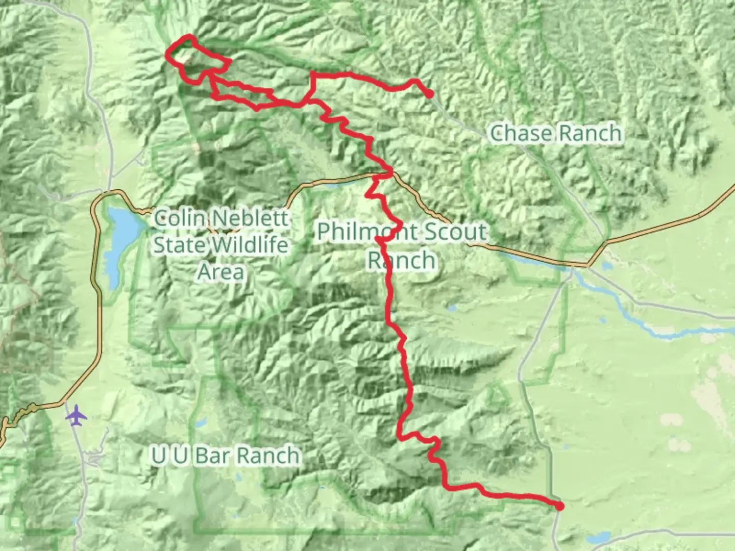
Embarking on the Baldy Mountain and Ute Creek and South Ponil Creek trail is a journey through the rugged beauty of New Mexico's wilderness. This challenging point-to-point trail stretches approximately 118 kilometers (about 73 miles) with an elevation gain of around 3,800 meters (approximately 12,467 feet), offering hikers a demanding yet rewarding experience.
Getting There
The trailhead is located near Colfax County, New Mexico. For those traveling by car, the nearest significant landmark is the town of Cimarron, which is accessible via US Highway 64. From Cimarron, head north on NM-21 until you reach the trailhead. Public transport options are limited in this remote area, so driving is recommended. However, if you're relying on public transport, the nearest major city is Albuquerque, from where you can take a bus to Raton and then arrange for a local taxi or shuttle service to Cimarron.
Trail Highlights and Landmarks
Baldy Mountain: As you begin your hike, one of the most prominent features is Baldy Mountain, which stands at an impressive 3,840 meters (12,631 feet). This peak is a significant landmark and offers panoramic views of the surrounding landscape. The ascent to Baldy Mountain is steep and challenging, so be prepared for a strenuous climb. The area is rich in mining history, with remnants of old gold mines that date back to the late 19th century, offering a glimpse into the region's past.
Ute Creek and South Ponil Creek: As you continue along the trail, you'll encounter the serene waters of Ute Creek and South Ponil Creek. These creeks provide a refreshing contrast to the rugged terrain and are ideal spots for a rest. The lush vegetation along the creek banks supports a diverse range of wildlife, including deer, elk, and various bird species. Keep an eye out for these creatures, especially during the early morning or late afternoon.
Navigating the Trail
Given the trail's difficulty, it's crucial to have reliable navigation tools. The HiiKER app is highly recommended for its detailed maps and real-time updates, ensuring you stay on course throughout your journey. The trail is well-marked, but weather conditions can change rapidly, so always be prepared with appropriate gear and clothing.
Historical Significance
The region around Baldy Mountain is steeped in history. During the late 1800s, the area was a hub for gold mining, attracting prospectors from across the country. Today, hikers can explore the remnants of these mining operations, including old cabins and equipment, which serve as a testament to the area's rich past. The trail also traverses parts of the Philmont Scout Ranch, a large, privately owned ranch dedicated to youth development and outdoor education.
Wildlife and Nature
The diverse ecosystems along the trail range from alpine meadows to dense forests, providing habitats for a wide variety of flora and fauna. In addition to larger mammals like deer and elk, you may also encounter smaller creatures such as marmots and chipmunks. Birdwatchers will appreciate the opportunity to spot species like the mountain bluebird and the peregrine falcon.
Preparation and Safety
Due to the trail's length and elevation gain, it's essential to be well-prepared. Ensure you have enough food, water, and supplies for the entire hike. Weather can be unpredictable, so pack layers and be ready for sudden changes. Cell service is limited, so inform someone of your plans before setting out. With proper preparation, this trail offers an unforgettable adventure through one of New Mexico's most stunning landscapes.

What to expect?
Activity types
Comments and Reviews
User comments, reviews and discussions about the Baldy Mountain and Ute Creek and South Ponil Creek, New Mexico.
average rating out of 5
0 rating(s)