Download
Preview
Add to list
More
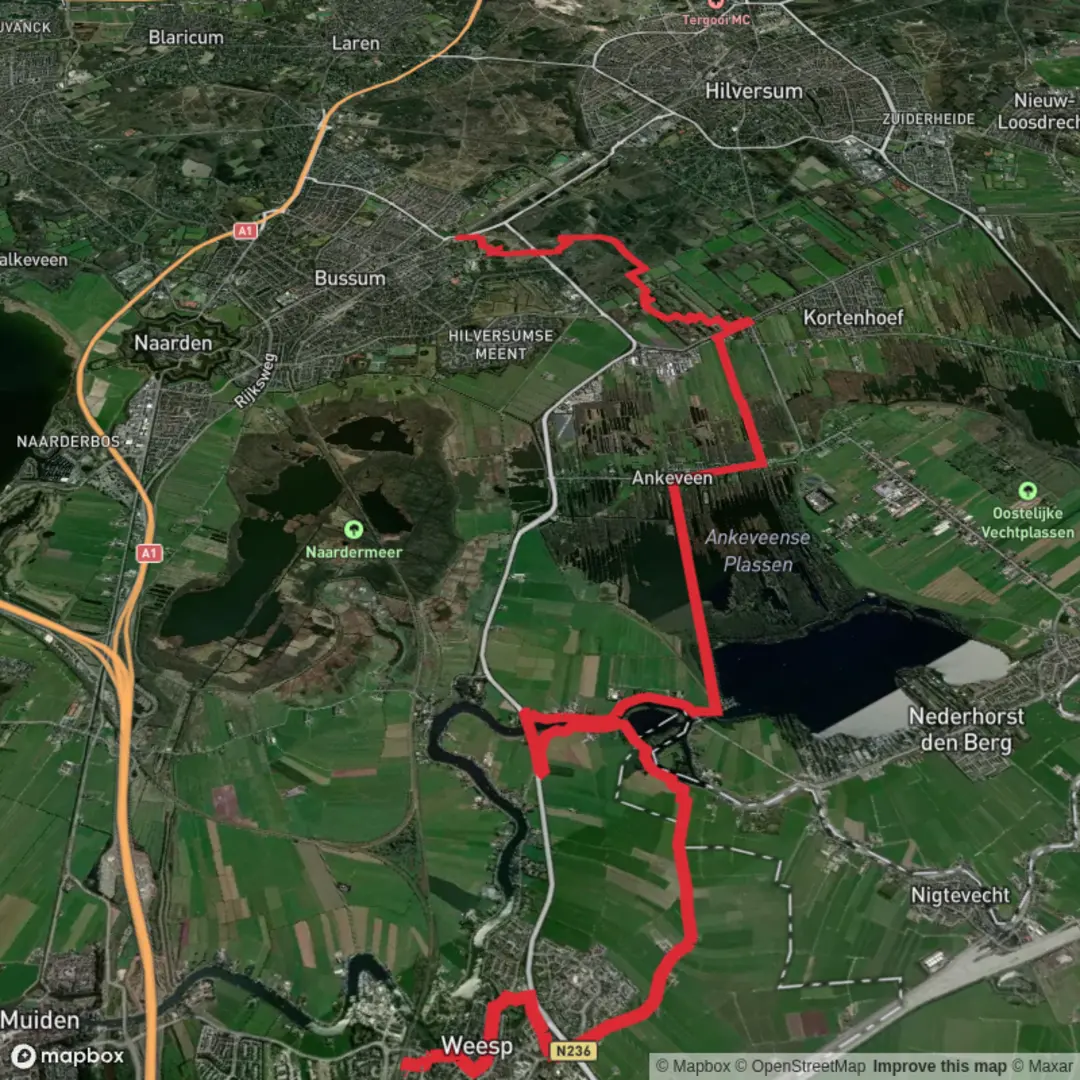
20.8 km
~4 hrs 9 min
0 m
Point-to-Point
“From riverside charm to star-shaped fortresses, this walk weaves Dutch history and nature into one unforgettable journey.”
Starting from the charming town of Weesp, this section of the Trekvogelpad (Peregrine Path) covers approximately 21 km (13 miles) with virtually no elevation gain, making it accessible for most walkers. The trailhead is conveniently located near Weesp railway station, a well-connected hub just southeast of Amsterdam. Trains from Amsterdam Centraal reach Weesp in about 15 minutes, and there is ample parking available for those arriving by car.
Urban Beginnings and River Views
The route begins in Weesp, a historic town known for its picturesque canals, windmills, and 17th-century architecture. As you leave the station, you’ll quickly find yourself walking alongside the Vecht River, a waterway lined with stately homes and lush greenery. The first few kilometers offer a blend of urban charm and riverside tranquility, with opportunities to spot herons, swans, and other waterfowl.
Crossing the Dutch Polder Landscape
After leaving Weesp, the trail heads east into the heart of the Dutch polder landscape. This region is characterized by flat, open fields, drainage ditches, and grazing livestock. The path is well-marked and mostly follows quiet country lanes and dike roads. Expect expansive views across meadows dotted with cows and sheep, and in spring, the fields may be ablaze with wildflowers. The lack of elevation (0 meters/0 feet) means the walking is easy, but wind can be a factor, so pack accordingly.
Naardermeer Nature Reserve
Around the halfway point, the trail skirts the edge of the Naardermeer, the oldest nature reserve in the Netherlands. This wetland area is a haven for birdlife, including spoonbills, grebes, and the rare bittern. There are several bird hides along the route, perfect for a rest and some wildlife spotting. The reserve’s reed beds and open water are remnants of the region’s peat-cutting history, and interpretive signs provide insight into the area’s ecological and historical significance.
Historic Naarden and Fortifications
As you approach the town of Naarden, the route passes close to one of the best-preserved star forts in Europe. Naarden’s 17th-century fortifications, complete with moats and bastions, are a highlight for history enthusiasts. The town itself is worth a short detour, with cobbled streets, a grand church, and several museums. The Trekvogelpad continues south, following green corridors and quiet suburban streets.
Final Stretch to Bussum Zuid
The last section leads through wooded areas and parkland as you approach Bussum Zuid. This area is known for its stately villas and leafy avenues, a contrast to the open fields earlier in the day. The trail ends near Bussum Zuid railway station, which offers frequent train connections to Amsterdam, Utrecht, and other major cities.
Navigation and Planning
The entire route is well-signposted, but for detailed navigation and up-to-date trail conditions, use HiiKER. The flat terrain and easy access to public transport at both ends make this hike ideal for a day trip. Bring water and snacks, as services are limited between Weesp and Naarden, though both towns offer cafes and shops.
This stretch of the Trekvogelpad offers a quintessential Dutch hiking experience, blending history, nature, and the unique landscapes of North Holland.

Surfaces
Unknown
Grass
Asphalt
Sand
Ground
Dirt
Wood
Comments and Reviews
User comments, reviews and discussions about the Weesp to Bussum Zuid via Trekvogelpad, Netherlands.
average rating out of 5
0 rating(s)