Download
Preview
Add to list
More
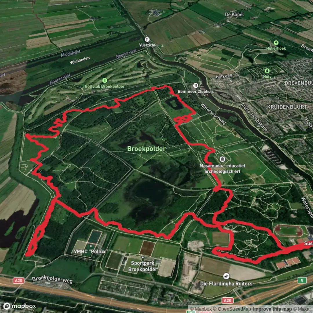
10.3 km
~2 hrs 3 min
0 m
Loop
“Wander through blooming meadows, tranquil waterways, and ancient woods on this gentle, nature-filled circuit.”
Starting from the edge of Vlaardingen, the Broekpolder Loop is a flat, circular route of approximately 10 km (6.2 miles) with virtually no elevation gain, making it accessible for hikers of all abilities. The trailhead is conveniently located near the Broekpolder recreational area, just west of Vlaardingen, close to the intersection of Watersportweg and Broekpolderweg. This area is easily reached by car, with parking available at the Broekpolder recreation parking lot. For those using public transport, Vlaardingen West railway station is the nearest major stop; from there, local buses or a short taxi ride will bring you to the trailhead.
Navigating the Route
The Broekpolder Loop is well-marked, but for added confidence, hikers should use HiiKER for up-to-date navigation and trail information. The loop follows a mix of gravel paths, grassy tracks, and some paved sections, all of which are flat and suitable for families, casual walkers, and even those with strollers. The absence of significant elevation (0 metres/0 feet) means the route is not physically demanding, but sturdy walking shoes are still recommended, especially after rain when some sections can be muddy.
Natural Highlights and Wildlife
Broekpolder is a reclaimed polder landscape, characterized by wide open meadows, reed beds, and tranquil waterways. The area is a haven for birdlife; expect to see herons, swans, and various species of ducks along the canals, especially in spring and autumn. The meadows are dotted with wildflowers in late spring and early summer, attracting butterflies and bees. The route passes through several wooded patches, where you might spot rabbits or, with luck, a roe deer in the early morning or late evening.
Landmarks and Points of Interest
At around 3 km (1.9 miles), the trail skirts the edge of the Vlaardingen Woods, a young forest planted as part of regional rewilding efforts. Here, interpretive signs explain the area's transformation from agricultural land to a recreational and ecological zone. Continuing along the loop, you’ll pass several small lakes and ponds, remnants of former peat extraction, now popular with local anglers and home to frogs and dragonflies.
At approximately 7 km (4.3 miles), the route brings you near the Broekpolder Archaeological Park, where reconstructed prehistoric dwellings and information panels offer insight into the region’s ancient history. Vlaardingen is known for the Vlaardingen Culture, a Neolithic community that settled here over 4,500 years ago. The park provides a glimpse into their daily life and the tools they used, making this a worthwhile stop for history enthusiasts.
Facilities and Practical Information
Rest areas with benches are spaced along the route, particularly near the lakes and wooded sections. There are several picnic spots, and a small café operates seasonally near the main parking area, offering refreshments and restrooms. Dogs are welcome but should be kept on a leash in wildlife-sensitive zones. Cyclists also use some sections of the trail, so be mindful at path intersections.
The Broekpolder Loop is accessible year-round, though the best times to visit are late spring and early autumn when the landscape is at its most vibrant. For navigation and trail updates, HiiKER provides reliable maps and route details.

Surfaces
Gravel
Unknown
Unpaved
Wood
Grass
Comments and Reviews
User comments, reviews and discussions about the Broekpolder Loop, Netherlands.
average rating out of 5
0 rating(s)