Download
Preview
Add to list
More
2.2 km
~26 min
0 m
Loop
“Wander through willow forests and wildflower meadows, where tranquil waters reflect the heart of Holland.”
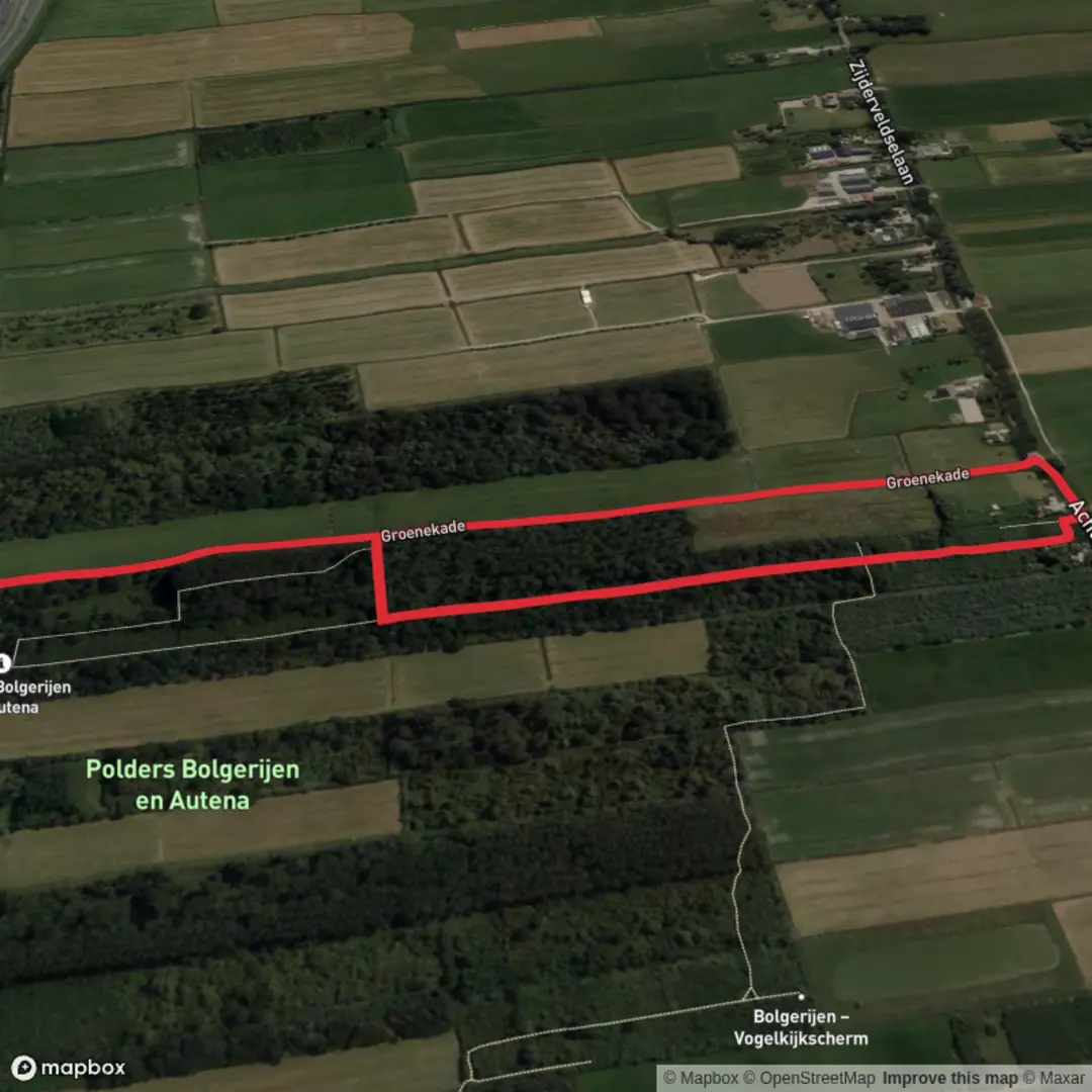
The Groenekade Loop via Bolgerijen Blauw is a serene 1.5-kilometer (approximately 0.93-mile) circular trail located near Vianen in the province of Utrecht, Netherlands. This easy, flat route offers hikers an opportunity to immerse themselves in the tranquil landscapes of the Tielerwaard region, characterized by its expansive polders, waterways, and rich biodiversity.
Trailhead and Access
The trail begins at the parking area on Bolgerijse Kade in Vianen. To reach the parking lot, navigate to Bolgerijse Kade 19, Vianen; the entrance is situated adjacent to this address. For those using public transportation, Vianen is accessible by bus from Utrecht Central Station. Upon arrival in Vianen, local buses or a short taxi ride can bring you to the trailhead.
Trail Overview
Starting from the parking area, the path meanders through the Polder Bolgerijen, one of the largest inland willow coppice areas in Europe. The trail is predominantly unpaved, providing an authentic hiking experience. As you traverse the route, you'll encounter a diverse array of flora and fauna, including rows of pollard willows, willow coppices, and flower-rich grasslands. The flat terrain makes it suitable for hikers of all ages and skill levels.
Key Landmarks and Points of Interest
- Willow Coppices: Approximately 0.5 kilometers (0.31 miles) into the hike, you'll enter a griendbos (willow coppice forest), showcasing willows in various growth stages. This area is a testament to traditional Dutch land management practices.
- Birdwatching Opportunities: Around the 1-kilometer (0.62-mile) mark, a birdwatching screen overlooks a water feature where large numbers of waders, ducks, and other waterfowl are often observed. This spot is ideal for nature enthusiasts and photographers.
- Groenekade: As you continue, the trail leads you along the Groenekade, offering picturesque views of the surrounding polder landscape. This section is particularly enchanting during sunrise or sunset.
Trail Conditions and Recommendations
While the trail is generally well-maintained, certain sections can become muddy during wet periods. It's advisable to wear waterproof footwear to ensure comfort throughout the hike. In early summer, parts of the path may be overgrown with nettles and brambles; wearing long pants is recommended to avoid discomfort. Additionally, some segments of the trail do not permit dogs, even if leashed, so it's important to adhere to local regulations.
Historical Significance
The Tielerwaard region, encompassing the Polder Bolgerijen, has a rich history of land reclamation and water management. The extensive willow coppices are a result of centuries-old practices where willows were cultivated for their flexible branches, used in basketry and other crafts. Walking through this area offers a glimpse into the Netherlands' enduring relationship with its waterways and the ingenuity employed to harness and coexist with nature.
Getting There
- By Car: From Utrecht, take the A2 motorway southbound and exit at Vianen. Follow local roads to Bolgerijse Kade 19, where parking is available near the trailhead.
- By Public Transport: From Utrecht Central Station, board a bus to Vianen. Upon arrival, local bus services or a short taxi ride can take you to the starting point on Bolgerijse Kade.
Embarking on the Groenekade Loop via Bolgerijen Blauw provides a peaceful retreat into nature, allowing hikers to experience the unique landscapes and ecological richness of the Dutch polder system.

Surfaces
Grass
Dirt
Unknown
Asphalt
Wood
Concrete
Comments and Reviews
User comments, reviews and discussions about the Groenekade Loop via Bolgerijen Blauw, Netherlands.
average rating out of 5
0 rating(s)