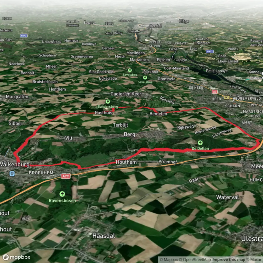
Ruine De Valk, Strabeek, De Dellen via Geul Weg, De Dellen Weg and Bemeler Weg
Download
Preview
Add to list
More
20.2 km
~4 hrs 13 min
117 m
Loop
“Wander through castle ruins, wildflower meadows, and sunken lanes—South Limburg’s landscape dazzles at every turn.”
Starting from the outskirts of Valkenburg, near the recognizable Ruine De Valk, this 20 km (about 12.4 miles) loop hike offers a gentle elevation gain of approximately 100 metres (328 feet), making it accessible for most walkers. The trailhead is conveniently located near Valkenburg’s historic castle ruins, a short walk from Valkenburg railway station, which is well-served by trains from Maastricht and Heerlen. For those arriving by car, parking is available in Valkenburg’s town centre, with several lots within a 10-minute walk of the start.
Historic Beginnings and Ruins
The route begins near the iconic Valkenburg Castle Ruins (Ruïne van Valkenburg), the only hilltop castle in the Netherlands, dating back to the 11th century. The ruins are a striking landmark and set the tone for a hike rich in history. As you leave the town, you’ll pass through Strabeek, a small hamlet with traditional Limburg farmhouses and a peaceful rural atmosphere.
Through the Geul Valley and De Dellen
Following the Geul Weg, the trail meanders alongside the Geul River, a lifeline for the region’s flora and fauna. The riverbanks are lush, especially in spring and summer, with wildflowers and the occasional kingfisher darting over the water. The path is mostly flat, with only gentle undulations as you approach De Dellen, a nature reserve known for its rolling meadows and patches of ancient woodland. Here, you might spot roe deer grazing at dawn or dusk, and the air is filled with birdsong from species like the Eurasian jay and woodpecker.
Open Meadows and Panoramic Views
Transitioning onto De Dellen Weg, the landscape opens up to expansive meadows and gentle hills. The elevation gain is gradual, never steep, and rewards you with panoramic views over the South Limburg countryside. The Bemeler Weg section brings you closer to Bemelen, a village famous for its marlstone cliffs and caves, remnants of centuries-old quarrying. These cliffs are a haven for rare orchids and butterflies in late spring and early summer.
Navigation and Trail Conditions
The entire route is well-marked, but carrying a digital map on HiiKER is recommended for real-time navigation and to explore alternative paths or shortcuts if needed. The paths are a mix of gravel, dirt, and paved farm tracks, generally in good condition year-round, though some sections near the river can be muddy after heavy rain.
Cultural and Natural Highlights
Along the way, you’ll encounter several wayside chapels and shrines, reflecting the region’s Catholic heritage. The villages of Strabeek and Bemelen offer opportunities to stop for refreshments, with local cafés serving Limburgse vlaai (fruit tart) and regional beers. The area is also known for its unique “holle wegen” (sunken lanes), ancient paths worn deep into the loess soil by centuries of foot and cart traffic.
Getting There and Practical Tips
Valkenburg is easily accessible by train, with direct connections from Maastricht (about 15 minutes) and Heerlen (about 20 minutes). Buses also serve the town from surrounding villages. If driving, use the address “Grendelplein, Valkenburg” for the nearest parking to the castle ruins. Public toilets and water refill points are available in Valkenburg and Bemelen, but less frequent along the rural stretches, so plan accordingly.
This hike is ideal for those seeking a blend of history, nature, and gentle exercise, with plenty of opportunities to enjoy the unique landscape and cultural heritage of South Limburg.

Surfaces
Asphalt
Unknown
Gravel
Paved
Comments and Reviews
User comments, reviews and discussions about the Ruine De Valk, Strabeek, De Dellen via Geul Weg, De Dellen Weg and Bemeler Weg, Netherlands.
average rating out of 5
0 rating(s)