Download
Preview
Add to list
More
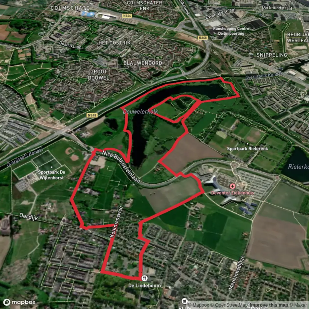
5.8 km
~1 hrs 9 min
0 m
Loop
“Winding through meadows, woodlands, and shimmering water, this tranquil loop reveals Deventer's natural and historic charm.”
Starting from the outskirts of Deventer, the trailhead for this 6 km (about 3.7 miles) loop is easily accessed near the Douwelerkolk, a scenic pond and nature reserve just southeast of the city center. The area is well-served by public transport: take a train to Deventer Station, then a local bus or a short bike ride will bring you to the start near Douwelerwetering. For those arriving by car, parking is available at the Douwelerkolk parking lot on Douwelerwetering, a convenient spot to begin your walk.
Trail Overview and Navigation
This route is almost entirely flat, with negligible elevation gain—perfect for beginners or those seeking a leisurely stroll. The path follows a section of the Sallandpad, a well-marked regional trail, and is best navigated using the HiiKER app for up-to-date route information and waypoints. The terrain consists of well-maintained gravel and dirt paths, with occasional grassy stretches, making it suitable for all fitness levels and accessible year-round.
Natural Highlights and Wildlife
The Douwelerkolk area is a haven for birdwatchers and nature lovers. The pond itself, formed from an old river meander, attracts a variety of waterfowl including herons, grebes, and ducks. Reed beds and willow thickets line the water’s edge, providing habitat for songbirds and small mammals. In spring and summer, wildflowers bloom along the banks, and dragonflies dart above the surface. The surrounding meadows and hedgerows are home to rabbits and, with luck, you might spot a roe deer grazing at dawn or dusk.
Cultural and Historical Context
This region of Salland has a rich agricultural history, with evidence of farming dating back to medieval times. The landscape is dotted with traditional Dutch farmhouses and small orchards, remnants of the area’s rural heritage. The Douwelerkolk itself was historically used for fishing and as a water source for livestock. As you walk, you’ll notice the characteristic Dutch polder landscape—flat fields crisscrossed by drainage ditches and bordered by rows of poplars, a testament to centuries of land reclamation and water management.
Points of Interest Along the Route
At approximately 2 km (1.2 miles), the trail skirts the edge of the Douwelerwetering, a canal that once played a vital role in local irrigation. Benches along the water offer peaceful spots to rest and enjoy the view. Around the halfway mark, you’ll pass through a small woodland, where the canopy provides welcome shade in summer and a burst of color in autumn. Interpretive signs along the route share information about local flora, fauna, and the history of the Douwelerkolk.
Practical Tips
There are no steep sections or technical challenges, but after heavy rain, some parts of the trail can become muddy—waterproof footwear is recommended. The route is popular with local walkers and cyclists, so expect some company, especially on weekends. Bring binoculars for birdwatching and a camera to capture the tranquil scenery. There are no facilities directly on the trail, but Deventer’s city center, with its cafes and shops, is just a short distance away for refreshments before or after your hike.

Surfaces
Unknown
Grass
Asphalt
Ground
Comments and Reviews
User comments, reviews and discussions about the Douwelerkolk via Sallandpad, Netherlands.
average rating out of 5
0 rating(s)