Download
Preview
Add to list
More
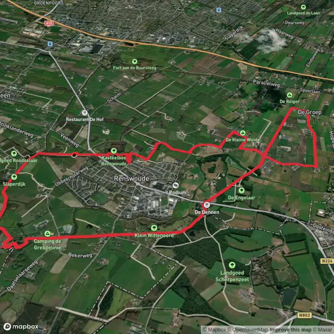
14.5 km
~2 hrs 54 min
0 m
Loop
“Stroll through storybook landscapes of dikes, wildflowers, and castle views on this peaceful countryside loop.”
Starting from the outskirts of Renswoude, a small village in the province of Utrecht, the Groeperkade and Daatselaarsepad Loop offers a gentle 15 km (about 9.3 miles) circuit with virtually no elevation gain, making it accessible for hikers of all levels. The trailhead is conveniently located near the intersection of Barneveldsestraat and Daatselaarseweg, just east of Renswoude Castle, a recognizable landmark that also provides a glimpse into the region’s storied past.
Getting There Renswoude is easily accessible by public transport. The nearest train station is Veenendaal-De Klomp, from which local buses run directly to Renswoude. For those arriving by car, parking is available near the castle grounds or along the quieter side streets adjacent to the trailhead.
Trail Overview and Navigation The loop follows a combination of grassy dikes, rural farm tracks, and quiet country lanes, weaving through the heart of the Gelderse Vallei. Navigation is straightforward, but the route crosses several intersecting paths and farmland boundaries, so using HiiKER for real-time guidance is highly recommended to stay on course.
Landmarks and Points of Interest Renswoude Castle and Estate Within the first kilometer, you’ll pass the moated Renswoude Castle, dating back to the 17th century. The estate’s manicured gardens and tree-lined avenues are open to the public and worth a short detour.
Groeperkade Dike The trail soon joins the Groeperkade, a historic dike built to protect the low-lying farmland from flooding. This section, stretching for about 3 km (1.9 miles), offers expansive views over the polder landscape, with grazing cattle and flocks of meadow birds such as lapwings and godwits. The dike itself is a testament to centuries of Dutch water management, and interpretive signs along the way provide insight into its construction and significance.
Daatselaarsepad and Farmland Turning south, the route follows the Daatselaarsepad, a traditional farmers’ path bordered by hedgerows and wildflowers. In spring and summer, the fields are alive with butterflies and the calls of skylarks. This area is also known for its small-scale agriculture, and you’ll pass several working farms—some of which sell fresh produce directly to hikers.
Nature and Wildlife The Gelderse Vallei is a haven for birdwatchers, especially during migration seasons. Marsh harriers, herons, and storks are commonly spotted, and the quiet, open terrain is ideal for observing hares and roe deer at dawn or dusk. The trail skirts several small ponds and drainage canals, where frogs and dragonflies thrive.
Practical Considerations The entire loop is flat, with a total elevation gain of less than 5 metres (16 feet), and the paths are generally well-maintained. However, sections along the dike and farm tracks can become muddy after rain, so waterproof footwear is advisable. There are limited facilities along the route, but Renswoude village offers cafés, a bakery, and restrooms near the start and finish.
Historical Context The region’s landscape has been shaped by centuries of water management and agriculture. The Groeperkade dike, in particular, played a crucial role in protecting the area from the frequent floods that once threatened the Gelderse Vallei. The presence of Renswoude Castle and its estate reflects the area’s strategic and economic importance in Dutch history.
For navigation and up-to-date trail conditions, consult HiiKER before setting out.

Surfaces
Unknown
Unpaved
Asphalt
Ground
Sand
Gravel
Grass
Paved
Comments and Reviews
User comments, reviews and discussions about the Groeperkade and Daatselaarsepad Loop, Netherlands.
average rating out of 5
0 rating(s)