Download
Preview
Add to list
More
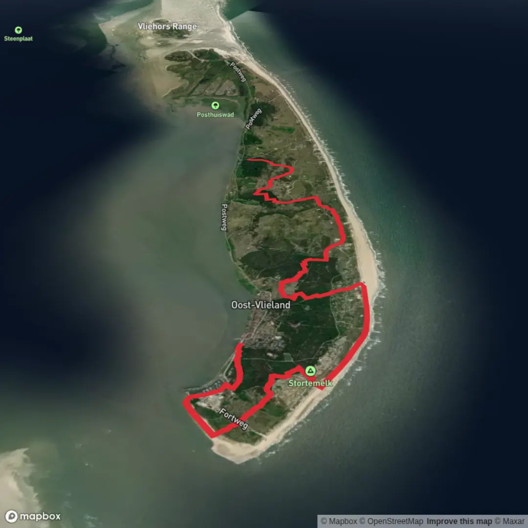
14.2 km
~2 hrs 53 min
40 m
Point-to-Point
“Wander Vlieland’s wild edge, where sweeping dunes, tidal flats, and seabirds paint an ever-changing coastal canvas.”
Starting from the eastern edge of Vlieland, near Oosterseveld, this 14 km (about 8.7 miles) route along the Waddenwandelen trail offers a unique, flat coastal hiking experience with virtually no elevation gain. The trail is well-suited for beginners and families, thanks to its easy terrain and well-marked paths. The starting point is accessible by taking the ferry from Harlingen to Vlieland, followed by a local bus or bicycle ride to Oosterseveld, which is close to the island’s eastern dunes and nature reserves.
Getting There and Trailhead Access
Vlieland is a car-free island, so visitors typically arrive via ferry from Harlingen Haven. Upon arrival at Vlieland’s ferry terminal, you can rent a bicycle or use the island’s bus service to reach Oosterseveld, located near the eastern dunes and the edge of the Kroon’s Polders nature reserve. The area is well-signposted, and the start of the trail is easy to find.
Trail Experience and Notable Features
The route follows the Waddenwandelen network, a series of trails that trace the Wadden Sea coast, a UNESCO World Heritage Site. The landscape is characterized by expansive sand dunes, salt marshes, and tidal flats. Early in the hike, you’ll pass through the Kroon’s Polders, a series of man-made wetlands created in the early 20th century for water management and bird conservation. This area is a haven for birdwatchers, especially during spring and autumn migrations, when thousands of waders and waterfowl stop to rest and feed.
Nature and Wildlife
As you progress westward, the trail skirts the edge of the island’s main dune ridge, offering panoramic views of the Wadden Sea to the north and the island’s interior to the south. The salt marshes and tidal flats are rich in biodiversity, supporting rare plant species such as sea lavender and glasswort. Seals are often spotted basking on sandbanks at low tide, and the air is filled with the calls of oystercatchers, curlews, and terns.
Historical and Cultural Highlights
Vlieland’s history is closely tied to the sea. The island was once a hub for shipping and whaling, and remnants of this maritime past can be seen in the old navigation beacons and the occasional shipwreck visible at low tide. The trail passes near the site of the former Vliehors military training area, now partially open to the public and known for its wide, sandy plains and striking isolation.
Navigation and Safety
The entire route is flat, with no significant elevation gain, making it accessible for most hikers. The trail is well-marked, but weather conditions can change rapidly, especially with strong winds coming off the North Sea. Waterproof clothing and sturdy footwear are recommended, as some sections can be muddy after rain. For navigation, HiiKER provides detailed maps and GPS tracks for the Waddenwandelen trails, ensuring you stay on course even in foggy or low-visibility conditions.
Finishing at Trafostation
The hike concludes near the Trafostation, a recognizable utility building close to the island’s western edge. From here, it’s possible to catch a local bus or cycle back to the ferry terminal in Oost-Vlieland, or continue exploring the island’s extensive network of walking and cycling paths. The end point is near the Vliehors Expres stop, a popular spot for guided tours of the island’s western sand flats.

Surfaces
Unknown
Sand
Ground
Dirt
Gravel
Concrete
Grass
Asphalt
Comments and Reviews
User comments, reviews and discussions about the Oosterseveld to Trafostation via Waddenwandelen - Vlieland, Netherlands.
average rating out of 5
0 rating(s)