Download
Preview
Add to list
More
9.3 km
~1 hrs 51 min
0 m
Loop
“Wander tranquil lakeshores and storied paths, where birdsong and history paint a vibrant Dutch tapestry.”
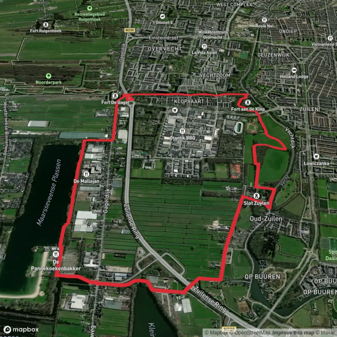
Embarking on the Maarsseveense Plassen via Koninklijke Weg and Berkenpad Loop offers a serene 9-kilometer (approximately 5.6 miles) journey through the picturesque landscapes of the Utrecht province in the Netherlands. With virtually no elevation gain, this easy loop is ideal for hikers of all levels, providing a delightful mix of natural beauty and historical landmarks.
Starting Point and Access
The trail begins at the Maarsseveense Plassen, a renowned recreational area located at Herenweg 53, 3602 AN Maarssen. For those arriving by car, ample parking is available at the recreation center. If using a navigation system, be aware that after exiting the N230 at Maarsseveen/Maarsseveense Plassen, you should cross the intersection to enter the parking lot directly, as some systems may incorrectly direct you onto Herenweg. ([visitgooivecht.nl](https://www.visitgooivecht.nl/en/locations/1341740911/top-maarsseveense-plassen?utm_source=openai))
Public transportation options are also convenient. From Utrecht Central Station, take bus 6 towards Overvecht, transfer to bus 35 at the Zamenhofdreef stop, and alight at Maarsseveense Plassen. Alternatively, from Maarssen station, take bus 34 or 36, transfer to bus 35 at Dr. Plesmanlaan, and disembark at Maarsseveense Plassen. ([visitgooivecht.nl](https://www.visitgooivecht.nl/en/locations/1341740911/top-maarsseveense-plassen?utm_source=openai))
Trail Overview
Commencing from the Maarsseveense Plassen, the loop guides you along the Koninklijke Weg and Berkenpad, weaving through a diverse tapestry of environments. The path is predominantly flat and well-maintained, making it accessible for hikers of all ages and abilities.
Natural Highlights
As you traverse the trail, you'll be enveloped by lush forests and open meadows, offering a habitat for a variety of bird species. The Maarsseveense Plassen themselves are a haven for waterfowl, including grebes, coots, and mallards. The surrounding woodlands are home to songbirds such as the chiffchaff, great tit, and nuthatch. Keep an eye out for these avian inhabitants, especially during the early morning or late afternoon when they are most active. ([komoot.com](https://www.komoot.com/smarttour/1547691?utm_source=openai))
Historical Significance
The region is steeped in history, notably as part of the New Dutch Waterline, a series of fortifications designed to protect the Netherlands by means of controlled flooding. Along the route, you may encounter Fort Maarsseveen, constructed between 1880 and 1881 to defend the Maarsseveense Vaart and surrounding polders. This fortification is a testament to the area's strategic importance in Dutch military history. ([routiq.com](https://routiq.com/route/623523?utm_source=openai))
Amenities and Points of Interest
The Maarsseveense Plassen area offers various amenities to enhance your hiking experience. Adjacent to the trailhead, you'll find De Pannekoekenbakker, a pancake restaurant perfect for a pre- or post-hike meal. The recreation area also features a beach, playgrounds, and picnic spots, making it an excellent destination for families. ([visitgooivecht.nl](https://www.visitgooivecht.nl/en/locations/1341740911/top-maarsseveense-plassen?utm_source=openai))
Navigation and Safety
For seamless navigation, consider using HiiKER, a comprehensive tool that provides detailed maps and trail information. The paths are well-marked, but it's always advisable to carry a map or GPS device. Given the flat terrain and well-maintained trails, the hike is rated as easy. However, always check the weather forecast before setting out, as conditions can change rapidly.
Getting There
To reach the Maarsseveense Plassen by car, from the A2 motorway, take the exit for Utrecht-Noord N230 (Ring Utrecht/Maarssen). After a few kilometers, take the Maarsseveen/Maarsseveense Plassen exit. Cross the intersection to enter the recreation center's parking lot directly. For public transport users, from Utrecht Central Station, take bus 6 towards Overvecht, transfer to bus 35 at Zamenhofdreef, and alight at Maarsseveense Plassen. From Maarssen station, take bus 34 or 36, transfer to bus 35 at Dr. Plesmanlaan, and disembark at Maarsseveense Plassen. ([visitgooivecht.nl](https://www.visitgooivecht.nl/en/locations/1341740911/top-maarsseveense-plassen?utm_source=openai))
Embarking on this loop offers a delightful blend of natural beauty and historical intrigue, making it a rewarding experience for any hiker.

Surfaces
Unknown
Asphalt
Dirt
Paved
Wood
Comments and Reviews
User comments, reviews and discussions about the Maarsseveense Plassen via Koninklijke Weg and Berkenpad Loop, Netherlands.
average rating out of 5
0 rating(s)