Download
Preview
Add to list
More
32.8 km
~2 days
0 m
Multi-Day
“Wander through a living Dutch tapestry—where tranquil waters, wild birds, and royal history paint every step.”
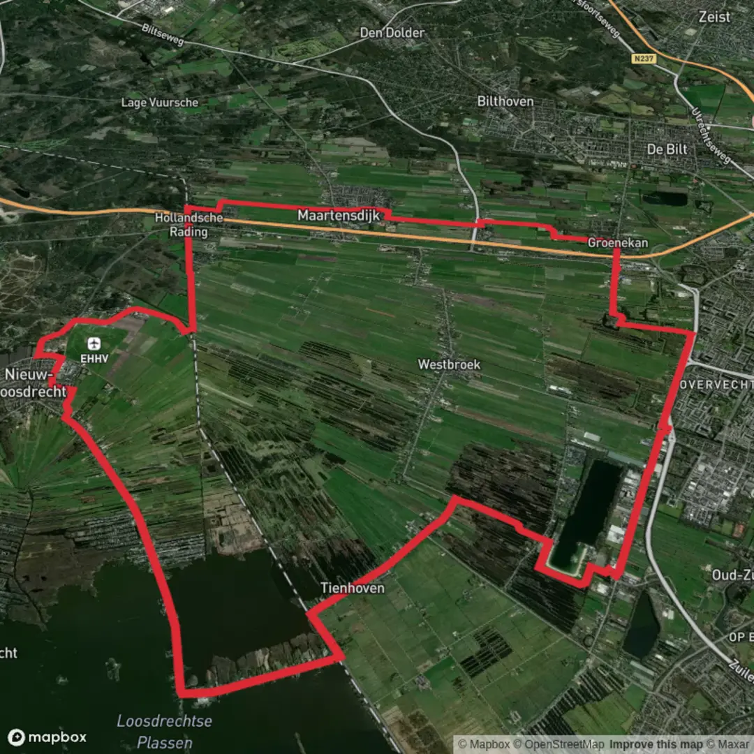
Starting from the tranquil outskirts near Muyeveld, this 33 km (about 20.5 miles) loop hike offers a flat, easy-going journey through the heart of the Dutch polder landscape, with virtually no elevation gain—perfect for those seeking a long but gentle day out. The trailhead is conveniently accessed from the village of Muyeveld, which is best reached by taking a train to Hilversum and then a local bus or taxi to the starting point. For those arriving by car, parking is available near the village center.Navigating the Dutch PoldersThe route follows the historic Koninklijke Weg, or Royal Road, a centuries-old path that once connected royal estates and hunting grounds. The trail meanders through a patchwork of meadows, waterways, and reed beds, characteristic of the Vechtstreek region. Early on, you’ll skirt the banks of the Vecht River, where stately country houses and old windmills line the water, offering a glimpse into the area’s prosperous past as a retreat for Amsterdam’s wealthy merchants.Highlights and LandmarksAt around 8 km (5 miles), you’ll pass through the charming village of Tienhoven, known for its traditional Dutch houses and the nearby Tienhovense Plassen—a series of shallow lakes and wetlands. This area is a haven for birdwatchers, with chances to spot herons, grebes, and even the rare bittern among the reeds. The trail continues along quiet dikes and towpaths, with expansive views across the open polder landscape. Keep an eye out for grazing sheep and the occasional roe deer in the fields.Nature and WildlifeBetween 15 and 25 km (9–15.5 miles), the route traverses several nature reserves, including the Ankeveense Plassen and the Loosdrechtse Plassen. These peat lakes are remnants of centuries-old turf cutting and now serve as important habitats for waterfowl and aquatic plants. In spring and summer, the air is alive with the calls of lapwings and the sight of dragonflies skimming the water’s surface. Wooden boardwalks and small bridges provide dry passage over marshy ground, and benches along the way invite you to pause and enjoy the peaceful scenery.Historical SignificanceThe Koninklijke Weg itself is steeped in history, once serving as a strategic route for royal carriages and later as a vital link between rural communities. Along the way, you’ll encounter remnants of old fortifications, part of the Dutch Water Line—a defensive system that used controlled flooding to protect the heartland from invaders. Informational signs detail the engineering marvels and military history of the region.Practical InformationThe entire route is well-marked and maintained, with wayfinding made easy using HiiKER for offline maps and navigation. There are several opportunities to stop for refreshments in Tienhoven and Ankeveen, where local cafés serve traditional Dutch fare. Public toilets are available at key points, and picnic areas are scattered throughout the reserves. The flat terrain and well-graded paths make this hike accessible year-round, though waterproof footwear is recommended in wetter months due to occasional muddy sections.Whether you’re drawn by the serene landscapes, the rich birdlife, or the echoes of Dutch history, this hike offers a rewarding exploration of one of the Netherlands’ most picturesque and storied regions.

Surfaces
Asphalt
Unknown
Paved
Ground
Concrete
Comments and Reviews
User comments, reviews and discussions about the Muyeveld and Tienhoven via Koninklijke Weg, Netherlands.
average rating out of 5
0 rating(s)