Download
Preview
Add to list
More
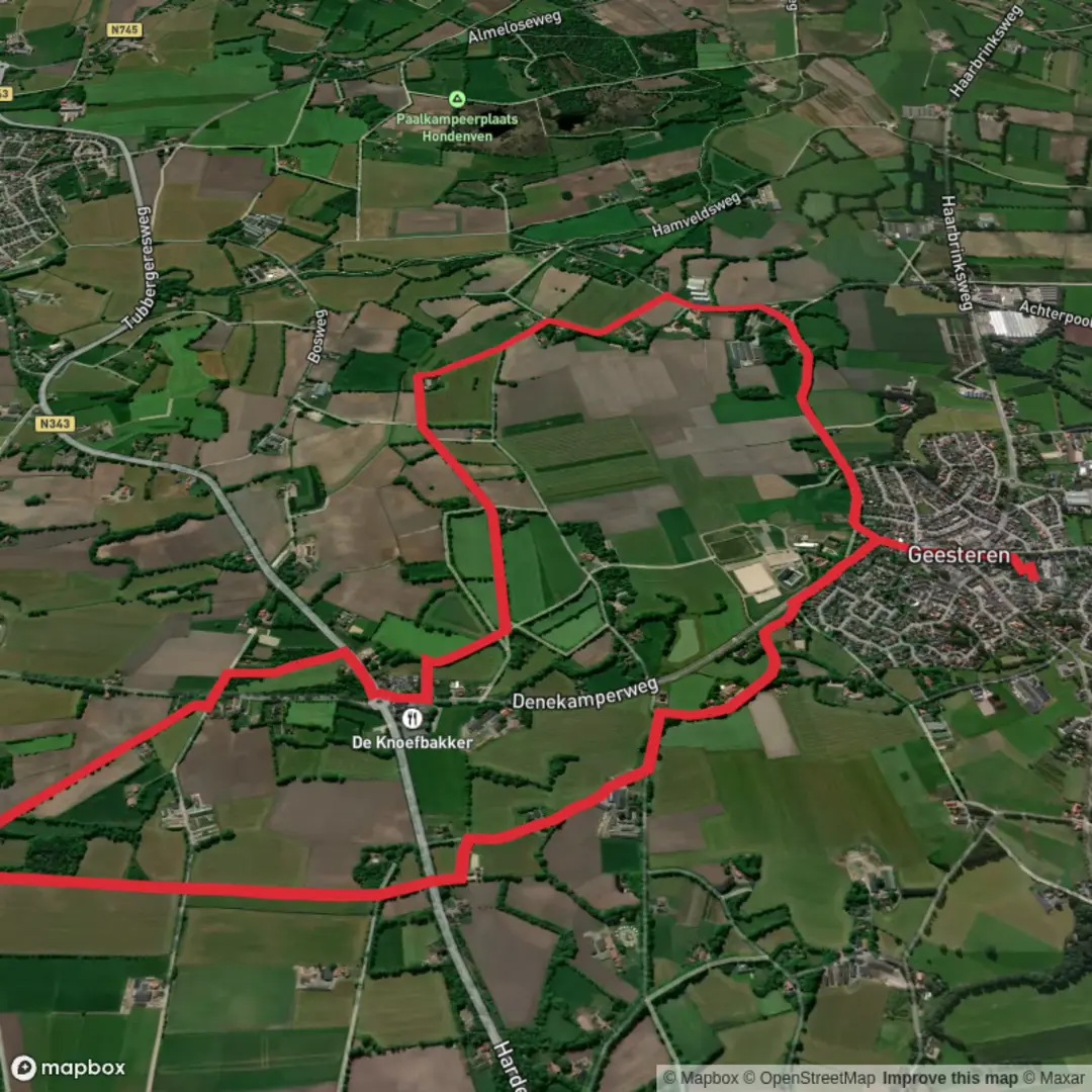
9.0 km
~1 hrs 48 min
0 m
Loop
“Wander through vibrant meadows, past historic windmills, and along peaceful streams in Geesteren’s countryside haven.”
Embark on a delightful 9-kilometer (approximately 5.6 miles) loop through the picturesque countryside of Geesteren in the Overijssel province of the Netherlands. This easy trail offers a serene experience with virtually no elevation gain, making it accessible for hikers of all levels.
Starting Point and Access
Begin your journey at the Noaberplein near Erve Kampboer, located at Kampboerlaan 6 in Geesteren. This area serves as a hub for several local walking routes and provides amenities such as an e-bike charging station and information about various trails. Parking is available on Geermanstraat, adjacent to the church in Geesteren. For those using public transport, the nearest bus stop is in the center of Geesteren, a short walk from the trailhead. ([landschapoverijssel.routemaker.nl](https://landschapoverijssel.routemaker.nl/content/pdf/routes/landschapoverijssel/nl/369-delmaroute-in-geesteren-ov.pdf?utm_source=openai))
Trail Highlights
- Grote Geesterse Molen: Early in the hike, you'll pass by this historic windmill, a testament to the region's rich agricultural heritage. The mill stands as a symbol of traditional Dutch engineering and offers a glimpse into the area's past.
- Herterij Twente: Approximately halfway through the loop, you'll encounter this charming spot, perfect for a restful break. Here, you can enjoy local delicacies and perhaps interact with some of the farm animals, adding a unique touch to your hiking experience.
- Broekbeek and Broekbeke Fish Ponds: As you continue, the trail meanders alongside the tranquil waters of the Broekbeek stream and the adjacent fish ponds. These areas are teeming with aquatic life and provide excellent opportunities for birdwatching. ([alltrails.com](https://www.alltrails.com/trail/netherlands/overijssel/geesteren-rode-wandelroute?utm_source=openai))
Natural Beauty and Wildlife
The route traverses a diverse landscape of lush farmlands, serene waterways, and verdant forests. Depending on the season, you might witness blooming wildflowers, hear the songs of various bird species, or even spot deer grazing in the distance. The flat terrain ensures a leisurely walk, allowing you to fully immerse yourself in the natural surroundings.
Historical Significance
Geesteren and its environs boast a rich history dating back centuries. The St. Pancratius Church, located near the starting point, is a notable landmark with architectural elements reflecting the region's cultural evolution. As you walk, consider the generations of farmers and millers who have shaped this landscape, leaving behind a legacy of resilience and community.
Navigation and Safety
The trail is well-marked with red arrows, guiding you seamlessly through the loop. For enhanced navigation, consider using the HiiKER app, which provides detailed maps and real-time updates. Always wear appropriate footwear, as some sections may be muddy after rain. While the path is generally safe, it's advisable to stay on marked trails to protect both yourself and the local flora and fauna.
Getting There
- By Car: From major cities like Amsterdam or Utrecht, take the A1 motorway towards Hengelo, then follow signs to Tubbergen and subsequently to Geesteren. Parking is available near the church on Geermanstraat.
- By Public Transport: From Enschede or Almelo, regional buses serve Geesteren. Alight at the Geesteren bus stop, from where it's a short walk to the Noaberplein starting point.
Embarking on this loop offers a harmonious blend of natural beauty, historical landmarks, and the tranquil charm of the Dutch countryside, making it a rewarding experience for any hiker.

Surfaces
Asphalt
Sand
Unknown
Ground
Concrete
Grass
Comments and Reviews
User comments, reviews and discussions about the De Huijer Oranje Route and Geesteren Rode Route Loop, Netherlands.
average rating out of 5
0 rating(s)