Download
Preview
Add to list
More
19.2 km
~3 hrs 49 min
0 m
Point-to-Point
“Embark on a breezy Texel loop where sea vistas, wild birds, and pastoral charm paint every step.”
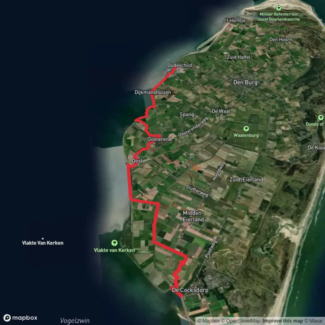
Starting from the southern edge of Texel, near the ferry terminal at 't Horntje, this 19 km (about 11.8 miles) loop hike offers a flat, easy-going adventure through some of the island’s most unique landscapes. With virtually no elevation gain, it’s accessible to most walkers and ideal for those seeking a relaxed day out immersed in nature.
Getting There
Reaching the trailhead is straightforward. If arriving by public transport, take the ferry from Den Helder to Texel’s 't Horntje terminal. Buses connect the ferry terminal with Den Burg and other villages on the island, making it easy to access the starting point. For those driving, parking is available near the ferry terminal, which serves as a convenient base for the hike.
Route Overview and Navigation
The route follows the Hollandseweg and sections of the Waddenwandelen trail, a long-distance path that traces the Wadden Sea coast. Navigation is simple, with well-marked paths and signposts. For precise route-finding and up-to-date trail conditions, HiiKER is recommended as your primary navigation tool.
Landscapes and Natural Highlights
The hike begins by skirting the southern dikes, offering sweeping views over the Wadden Sea—a UNESCO World Heritage site renowned for its tidal flats and rich birdlife. Early in the walk, you’ll pass salt marshes and mudflats teeming with waders and waterfowl, especially during migration seasons. Keep an eye out for spoonbills, avocets, and the occasional seal basking on the sandbanks.
Crossing Texel’s Heartland
Midway, the trail veers inland along the Hollandseweg, traversing Texel’s agricultural heartland. Here, you’ll encounter traditional Dutch farmsteads, fields of grazing sheep, and the iconic Texel lambs in spring. The landscape is punctuated by drainage ditches and windmills, reminders of the island’s centuries-old battle with the sea.
Historical and Cultural Points
Texel’s southern region has a rich maritime history. The nearby village of Oudeschild, a short detour from the route, was once a bustling harbor for the Dutch East India Company. The area around Werkhaven, your turnaround point, was historically significant as a work harbor for dike construction and maintenance, vital to the island’s survival.
Return Along the Wadden Coast
The final stretch brings you back along the Wadden Sea dike, with panoramic views across the tidal flats to the mainland. The interplay of light, water, and sky is ever-changing, making this section particularly photogenic. Interpretive panels along the dike explain the unique ecology of the Wadden Sea and the importance of its preservation.
Wildlife and Seasonal Considerations
Spring and autumn are prime times for birdwatching, as Texel is a key stopover on the East Atlantic Flyway. In summer, wildflowers bloom along the dikes and meadows, while winter brings bracing winds and dramatic skies. The flat, open terrain means weather can change quickly, so pack windproof layers and check forecasts before setting out.
Trail Services and Facilities
There are limited facilities directly on the route, but nearby villages such as Den Hoorn and Oudeschild offer cafes, shops, and restrooms. Water and snacks should be carried, especially outside the main tourist season when some services may be closed.
This easy, scenic loop is a quintessential Texel experience, blending coastal wilderness, rural charm, and a touch of Dutch history—all within a day’s walk.

Surfaces
Asphalt
Unknown
Grass
Concrete
Comments and Reviews
User comments, reviews and discussions about the Werkhaven via Hollandseweg and Waddenwandelen - Texel, Netherlands.
average rating out of 5
0 rating(s)