Download
Preview
Add to list
More
9.8 km
~1 hrs 59 min
21 m
Loop
“Wander through blooming heather, ancient mounds, and tranquil ponds on this enchanting Eeserveld journey.”
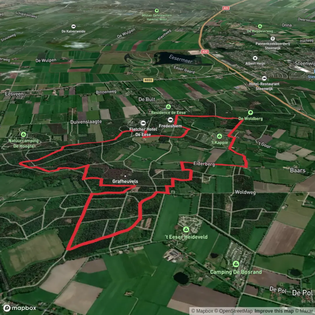
Embarking on the Eeserveld hike via Woldweg and Brauweringen offers a delightful journey through the serene landscapes of the Eeserveld region in Overijssel, Netherlands. This approximately 10-kilometer (6.2-mile) loop trail is predominantly flat, making it accessible for hikers of all levels.
Trailhead and Access
The hike begins near the village of Baars, specifically at Woldweg 3, 8336 KH, Baars. For those traveling by car, take the A32 motorway and exit at Steenwijk Noord (Exit 7). Follow signs towards Oldemarkt, and after approximately 600 meters (0.37 miles), turn right at the intersection in Witte Paarden. Continue straight, crossing the railway and motorway, and upon entering Baars, take the first right onto 't Goor, leading to the Woldberg parking area. This parking lot serves as the starting point for the hike. ([knnv.nl](https://knnv.nl/wandelingen/wandeltip-eeserveld-5-km/?utm_source=openai))
For those using public transportation, Steenwijk railway station is the nearest major hub. From there, local bus services or taxis can be used to reach Baars. It's advisable to check the latest schedules and routes via local transport services.
Trail Overview
Starting from the Woldberg parking area, the trail leads you along Brauweringen, a path flanked by diverse flora. In the adjacent woodlands, you'll encounter the broad buckler fern, a prominent species in the area. The path meanders through a mix of forested areas and open heathlands, offering a variety of natural sceneries. ([knnv.nl](https://knnv.nl/wandelingen/wandeltip-eeserveld-5-km/?utm_source=openai))
Natural Highlights
As you progress, the trail passes by a small pond known as Bertus de Boer's fen. This tranquil spot is home to aquatic plants like the water trefoil and lesser bladderwort. The surrounding forests are interspersed with patches of heath, especially vibrant during late summer when the heather blooms. Keep an eye out for local wildlife, including deer and various bird species that inhabit the area. ([knnv.nl](https://knnv.nl/wandelingen/wandeltip-eeserveld-5-km/?utm_source=openai))
Historical Significance
The Eeserveld region is rich in history. Notably, the area features several ancient burial mounds dating back to the Neolithic period. These mounds are remnants of early human settlements and offer a glimpse into the region's prehistoric past. Additionally, medieval cart tracks have been discovered here, indicating the area's long-standing significance as a travel route. ([routiq.com](https://routiq.com/route/176899/ontdek-de-natuur-van-het-eeserveld?utm_source=openai))
Navigation and Amenities
The trail is well-marked, but for enhanced navigation, consider using the HiiKER app, which provides detailed maps and route information. Along the route, there are several spots suitable for rest and picnics. Notably, near the Woldberg area, you'll find Tuk's Theehuis, a historic teahouse offering refreshments—a perfect place to pause and enjoy the surroundings. ([en.visitweerribbenwieden.com](https://en.visitweerribbenwieden.com/routes/56179/walking-eeserveld/?utm_source=openai))
Preparation Tips
Given the flat terrain and well-maintained paths, standard hiking gear is sufficient. However, after periods of rain, some sections might become muddy, so waterproof footwear is recommended. Always check the weather forecast before setting out and inform someone about your hiking plans.
This hike offers a harmonious blend of natural beauty and historical intrigue, making it a rewarding experience for those looking to explore the Dutch countryside.

Surfaces
Unknown
Asphalt
Ground
Sand
Concrete
Paved
Dirt
Grass
Gravel
Comments and Reviews
User comments, reviews and discussions about the Eeserveld via Woldweg and Brauweringen, Netherlands.
average rating out of 5
0 rating(s)