Download
Preview
Add to list
More
32.5 km
~2 days
22 m
Multi-Day
“Wander through storybook villages, riverside meadows, and timeless Hanseatic towns on this gentle Dutch adventure.”
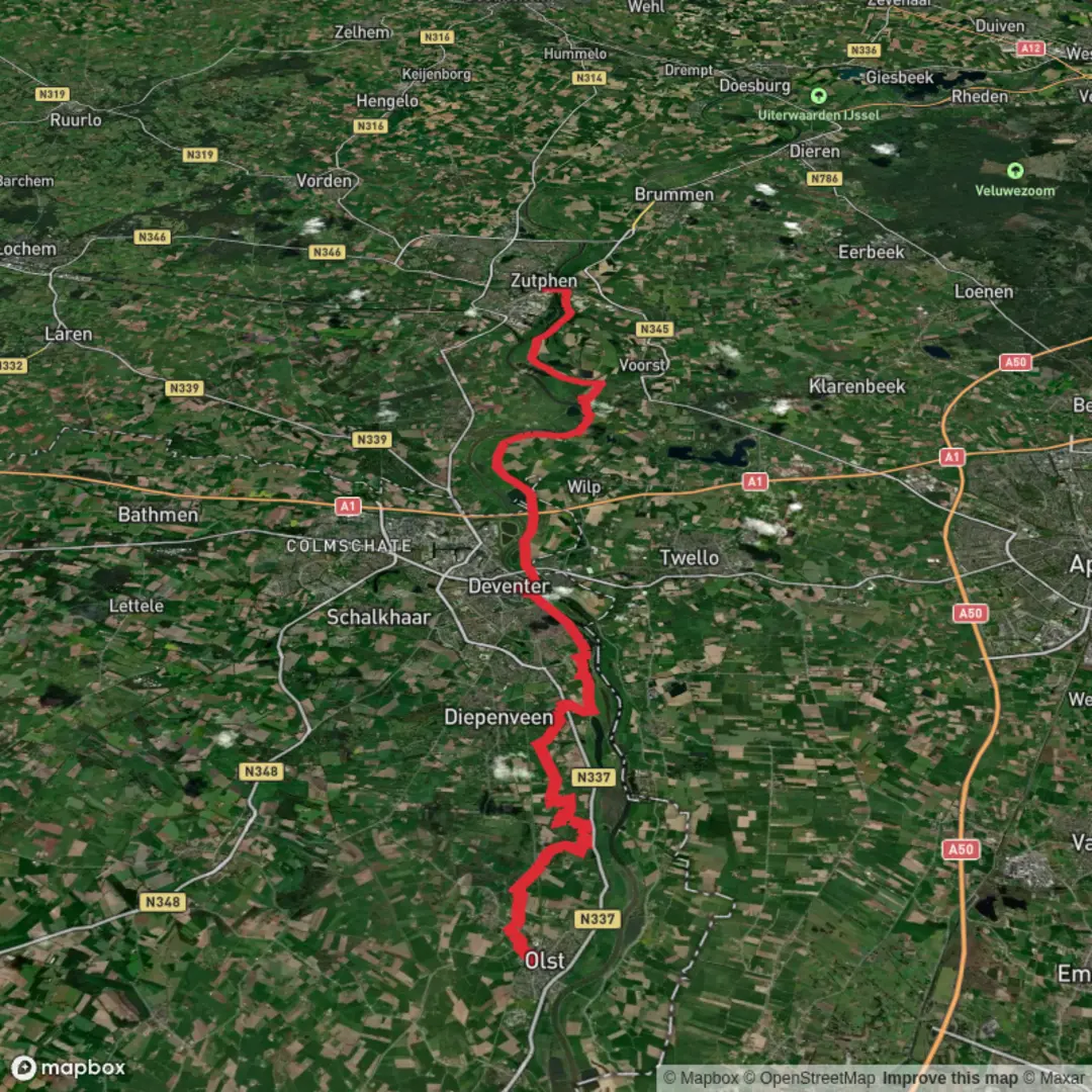
Starting from the charming town of Olst, this 32 km (about 20 miles) route follows the Sallandpad and Hanzestedenpad, two well-marked long-distance trails that wind through the heart of the Dutch province of Overijssel. With virtually no elevation gain, this hike is accessible to most walkers and is rated as easy, making it ideal for those looking to enjoy a full day’s journey through the Dutch countryside without strenuous climbs.
Getting There Olst is easily accessible by train, with regular services from Deventer and Zwolle. The trailhead is a short walk from Olst railway station, located near Stationsweg, Olst. For those arriving by car, parking is available near the station and in the town center.
Through Salland’s Farmland and River Landscapes Leaving Olst, the path quickly immerses you in the tranquil landscapes of Salland. Expect to walk along quiet dikes, through open meadows, and past traditional Dutch farms. The IJssel River is a constant companion for much of the route, offering sweeping views across its broad floodplains. Early in the hike, you’ll pass the Olster Molen, a historic windmill that’s a classic photo stop and a reminder of the region’s agricultural heritage.
Wildlife and Nature Highlights The floodplains along the IJssel are rich in birdlife, especially in spring and autumn when migratory species stop to rest. Look for storks, herons, and sometimes even sea eagles. The meadows and hedgerows are alive with wildflowers and butterflies in summer, and you may spot roe deer grazing at dawn or dusk.
Historic Towns and Hanseatic Heritage About halfway, you’ll skirt the edge of Wijhe, another riverside village with a centuries-old church and inviting cafés. Continuing south, the route follows the Hanzestedenpad, a trail that links the historic Hanseatic towns of the region. These towns flourished in the Middle Ages as part of a powerful trading league, and their legacy is visible in the architecture and layout of the settlements.
Approaching Zutphen The final stretch leads you into the outskirts of Zutphen, a beautifully preserved Hanseatic city. The skyline is dominated by church towers and medieval warehouses, and the cobbled streets invite exploration. The trail ends near Zutphen railway station, making it easy to return to your starting point or continue your journey.
Navigation and Planning The entire route is well signposted, but for detailed navigation and up-to-date trail conditions, use HiiKER. The app provides offline maps and waypoints, ensuring you stay on track even in more remote sections.
Facilities and Tips There are several small villages along the way where you can find refreshments, but services can be sparse on Sundays and holidays. Carry enough water and snacks for the day. Public toilets are available at Olst and Zutphen stations, and some cafés along the route.
This hike offers a gentle but rewarding journey through one of the Netherlands’ most scenic and historically rich regions, perfect for those seeking a blend of nature, culture, and easy walking.

Surfaces
Grass
Asphalt
Unknown
Concrete
Ground
Sand
Gravel
Wood
Dirt
Paved
Comments and Reviews
User comments, reviews and discussions about the Olst to Zutphen via Sallandpad and Hanzestedenpad, Netherlands.
average rating out of 5
0 rating(s)