Download
Preview
Add to list
More
8.0 km
~2 hrs 0 min
237 m
Loop
“Golden gorse, sweeping sea views, and echoes of history create a vibrant adventure around Howth Head.”
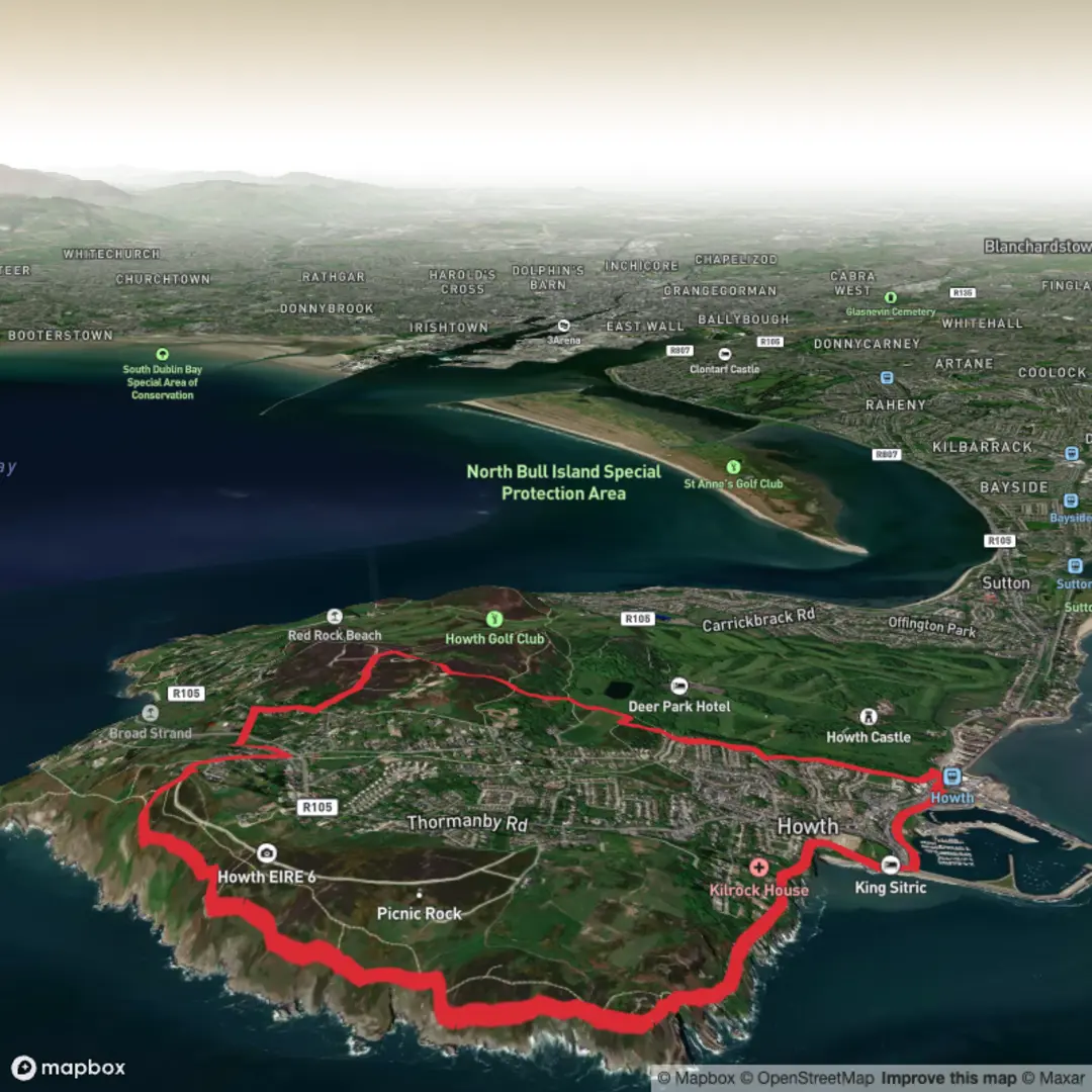
The Howth Black Linn Loop, marked by red arrows, is an approximately 8-kilometer (5-mile) trail with an elevation gain of about 160 meters (525 feet), offering a moderate hiking experience. ([visitdublin.com](https://www.visitdublin.com/howth-black-linn-loop?utm_source=openai))
Starting Point and Initial Ascent
Begin your hike at Howth Railway Station, situated in the heart of Howth Village. From the station, proceed along the promenade adjacent to Howth Harbour, following the red waymarkers. This initial stretch provides a pleasant walk along the marina, setting the tone for the journey ahead. As you reach the end of the promenade, veer right onto Balscadden Road. This road ascends gradually, leading you to Kilrock Car Park, where you'll join the well-trodden cliff path. ([visitdublin.com](https://www.visitdublin.com/howth-black-linn-loop?utm_source=openai))
Cliff Path and Coastal Views
The cliff path offers approximately 3 kilometers (1.9 miles) of stunning coastal scenery. As you traverse this section, you'll be treated to panoramic views of Lambay Island and Ireland's Eye, two prominent islands off the Dublin coast. The path is adorned with vibrant yellow gorse, emitting a distinctive coconut scent, especially during the blooming season. Keep an eye out for local wildlife; the cliffs are home to various seabirds, and grey seals are often spotted in the waters below. ([visitdublin.com](https://www.visitdublin.com/howth-black-linn-loop?utm_source=openai))
Ascent to The Summit
After enjoying the coastal views, the trail turns right, leaving the longer Bog of the Frogs Loop (marked in purple), and begins an ascent towards The Summit Car Park. This climb is steady and brings you to one of the highest accessible points on Howth Head. From here, you can enjoy expansive views of Dublin Bay and the surrounding areas. ([visitdublin.com](https://www.visitdublin.com/howth-black-linn-loop?utm_source=openai))
Inland Traverse and Black Linn
Exiting The Summit Car Park through the height restriction barrier, join Bailey Green Road and follow it downhill to a junction near The Summit Stores and pub. Turn left here, and after approximately 100 meters (328 feet), take a right onto a grassy pathway. Cross Carrickbrack Road to join another pathway that ascends Tweedy’s Hill. At the top, join Windgate Road, turn right, and after about 200 meters (656 feet), enter the hillside through a gateway on your left. This section, known locally as Black Linn, offers a series of paths across open hilltop terrain, eventually descending through the grounds of the local GAA Club and reaching the Balkill Park estate. ([visitdublin.com](https://www.visitdublin.com/howth-black-linn-loop?utm_source=openai))
Return via the Old Tramline
Upon entering Balkill Park, the trail intersects with the green and blue loops as you join the tramline pathway. This historic path follows the route of the old Hill of Howth Tramway, which operated from 1901 to 1959, connecting Sutton and Howth railway stations around the peninsula. The tramline pathway gently descends, leading you back to Howth Railway Station, completing the loop. ([visitdublin.com](https://www.visitdublin.com/howth-black-linn-loop?utm_source=openai))
Historical Significance
Howth Head has been a site of human activity since prehistoric times and features prominently in Irish mythology. The area is rich in history, with landmarks such as Howth Castle and the ruins of St. Mary's Church, which dates back to the 14th century. The Hill of Howth Tramway, whose path you traverse on the return leg, was an essential mode of transport in the early 20th century, enhancing connectivity and tourism in the region. ([en.wikipedia.org](https://en.wikipedia.org/wiki/Howth?utm_source=openai))
Accessing the Trailhead
To reach Howth Railway Station, you can take the DART (Dublin Area Rapid Transit) from Dublin city center, with regular services making it a convenient option. For those driving, parking is available near the station and throughout Howth Village. Public bus services also connect Dublin to Howth, providing multiple options for accessing the trailhead. ([en.wikipedia.org](https://en.wikipedia.org/wiki/Howth?utm_source=openai))
Preparation Tips
- Footwear and Clothing: Wear sturdy hiking boots, as the terrain includes both paved paths and uneven, rocky sections. Weather conditions can change rapidly; carrying rain gear is advisable.
- Navigation: While the trail is well-marked with red arrows, carrying a detailed map or using a navigation app like HiiKER can enhance your hiking experience.
- Safety: Some sections of the cliff path are close to the edge; exercise caution, especially in windy conditions.
- Amenities: Facilities such as rest

Surfaces
Asphalt
Dirt
Unknown
Gravel
Concrete
Ground
Wood
Comments and Reviews
User comments, reviews and discussions about the Howth Black Linn Loop - Red, Ireland.
average rating out of 5
0 rating(s)