Download
Preview
Add to list
More
10.1 km
~2 hrs 26 min
251 m
Loop
“Explore diverse landscapes and historical landmarks on this 10 km loop trail near Städteregion Aachen.”
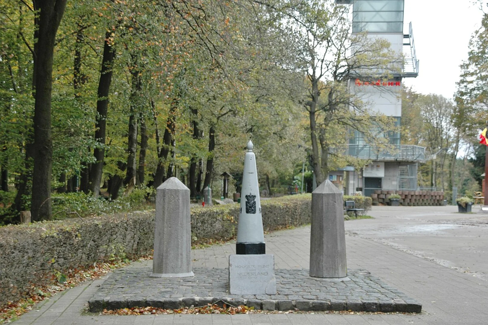
Starting near Städteregion Aachen, Germany, this 10 km (approximately 6.2 miles) loop trail offers a moderate challenge with an elevation gain of around 200 meters (656 feet). The trailhead is conveniently accessible by both car and public transport. If driving, you can park near the Dreiländereck, the tripoint where Germany, Belgium, and the Netherlands meet. For those using public transport, the nearest significant landmark is the Aachen Hauptbahnhof (Aachen Central Station), from where you can take a bus to the Dreiländereck.### Trail OverviewThe trail begins with a gentle ascent through lush forests, offering a serene start to your hike. As you progress, you'll encounter the Preusberg, a notable hill that provides panoramic views of the surrounding countryside. This section is relatively easy, making it a good warm-up for the more challenging parts ahead.### Key Landmarks and Points of Interest#### PreusbergAt approximately 2 km (1.2 miles) into the hike, you'll reach the summit of Preusberg. This vantage point offers stunning views of the rolling hills and valleys below. It's a great spot for a short break and some photography.#### StahlenbergContinuing on, you'll come to Stahlenberg around the 5 km (3.1 miles) mark. This area is rich in history, with remnants of old fortifications that date back to medieval times. The trail here becomes a bit steeper, so be prepared for a more strenuous climb. The effort is well worth it, as the summit offers another set of breathtaking views.#### Hoogste Punt van NederlandAround 7 km (4.3 miles) into the hike, you'll reach the Hoogste Punt van Nederland, the highest point in the Netherlands at 322.7 meters (1,059 feet) above sea level. This spot is marked by a large stone and offers a unique opportunity to stand at the highest elevation in the country. There are also informational plaques detailing the historical and geographical significance of the area.### Flora and FaunaThe trail is rich in biodiversity. You'll pass through dense forests of beech and oak, interspersed with open meadows that are home to a variety of wildflowers. Keep an eye out for local wildlife, including deer, foxes, and a variety of bird species. The area is particularly beautiful in the spring and autumn, when the foliage is at its most vibrant.### Navigation and SafetyGiven the moderate difficulty of the trail, it's advisable to use a reliable navigation tool like HiiKER to ensure you stay on track. The trail is well-marked, but having a digital map can provide additional peace of mind. Wear sturdy hiking boots, as some sections can be rocky and uneven. Bring plenty of water and snacks, especially if you plan to take your time exploring the various points of interest.### Getting ThereTo reach the trailhead, you can drive to the Dreiländereck, where parking is available. If you're using public transport, take a train to Aachen Hauptbahnhof and then a bus to the Dreiländereck. From there, it's a short walk to the start of the trail.This loop trail offers a perfect blend of natural beauty, historical landmarks, and moderate physical challenge, making it an excellent choice for hikers looking to explore the scenic and culturally rich region near Städteregion Aachen.

What to expect?
Activity types
Comments and Reviews
User comments, reviews and discussions about the Preusberg, Stahlenberg and Hoogste Punt van Nederland Loop via Sudweg, Germany.
4.33
average rating out of 5
3 rating(s)