Download
Preview
Add to list
More
7.3 km
~1 hrs 41 min
138 m
Loop
“Explore Bavarian beauty and history on the 7 km SalzAlpen Weg loop near Rosenheim.”
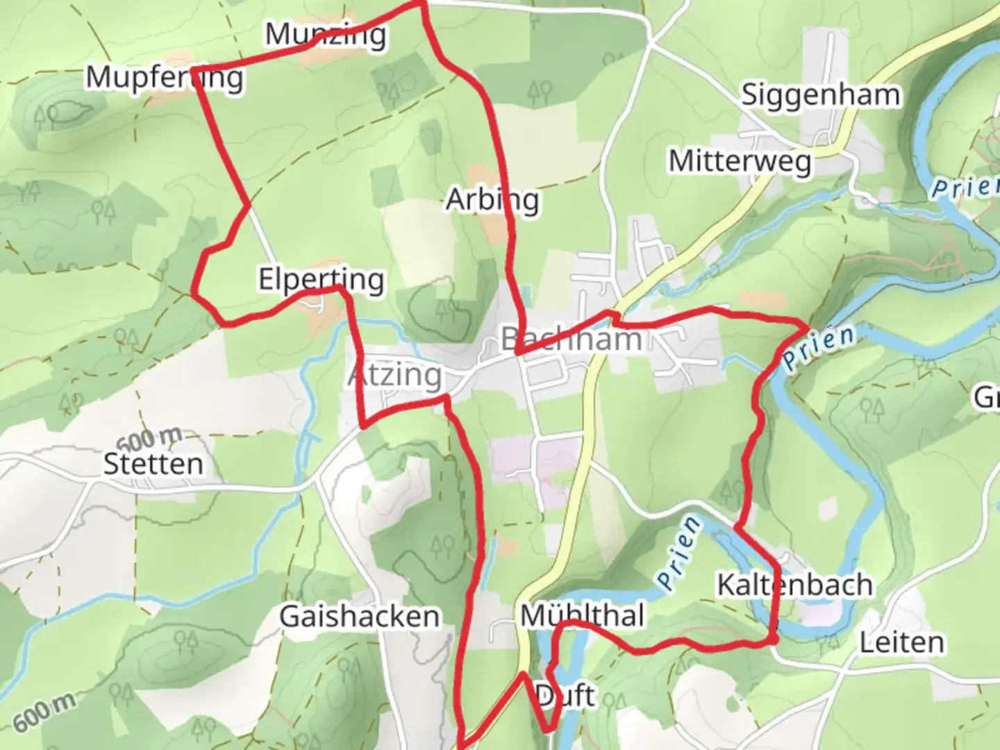
Starting near the picturesque town of Rosenheim, Germany, the SalzAlpen Weg - Rosenheim-Chiemsee and Priener Postkartenweg is a delightful loop trail that spans approximately 7 km (4.3 miles) with an elevation gain of around 100 meters (328 feet). This medium-difficulty trail offers a blend of natural beauty, historical significance, and serene landscapes, making it a perfect day hike for those looking to explore the Bavarian countryside.### Getting There To reach the trailhead, you can either drive or use public transport. If driving, head towards Rosenheim and look for parking near the town center or designated trail parking areas. For those using public transport, Rosenheim is well-connected by train. From the Rosenheim train station, you can take a local bus or a short taxi ride to the trailhead.### Trail Navigation For navigation, it's highly recommended to use the HiiKER app, which provides detailed maps and real-time updates to ensure you stay on the right path.### Trail Highlights As you embark on the trail, you'll first encounter lush meadows and rolling hills that are characteristic of the Bavarian landscape. The initial part of the hike is relatively flat, making it a gentle start. About 1 km (0.6 miles) in, you'll begin a gradual ascent, gaining approximately 50 meters (164 feet) in elevation over the next 2 km (1.2 miles).### Historical Significance This region is steeped in history, particularly related to the salt trade routes that once crisscrossed the area. The SalzAlpen Weg itself is part of a larger network of trails that were historically used to transport salt from the Alps to various parts of Europe. As you hike, you'll come across several informational plaques detailing the historical significance of these routes.### Nature and Wildlife The trail is a haven for nature enthusiasts. Keep an eye out for local wildlife such as deer, foxes, and a variety of bird species. The flora is equally impressive, with wildflowers dotting the meadows in spring and summer. The trail also passes through dense forests, offering a cool respite during warmer months.### Significant Landmarks Around the 4 km (2.5 miles) mark, you'll reach the Priener Postkartenweg, a scenic viewpoint that offers stunning vistas of the Chiemsee lake and the surrounding Alps. This spot is perfect for a short break and some memorable photographs. The viewpoint is aptly named "Postkartenweg," which translates to "Postcard Path," due to its picture-perfect scenery.### Final Stretch The last 3 km (1.8 miles) of the trail are mostly downhill, making for a pleasant and easy return to the starting point. As you descend, you'll pass through more meadows and small streams, eventually looping back to where you began.### Practical Tips - Wear sturdy hiking boots as some sections can be uneven. - Carry enough water and snacks, especially if you plan to take your time at the scenic viewpoints. - Check the weather forecast before heading out, as conditions can change rapidly in the mountains. - Use the HiiKER app for real-time navigation and updates.This trail offers a perfect blend of natural beauty, historical intrigue, and moderate physical challenge, making it a must-visit for anyone in the Rosenheim area.

Comments and Reviews
User comments, reviews and discussions about the SalzAlpen Weg - Rosenheim-Chiemsee and Priener Postkartenweg, Germany.
5.0
average rating out of 5
1 rating(s)