Download
Preview
Add to list
More
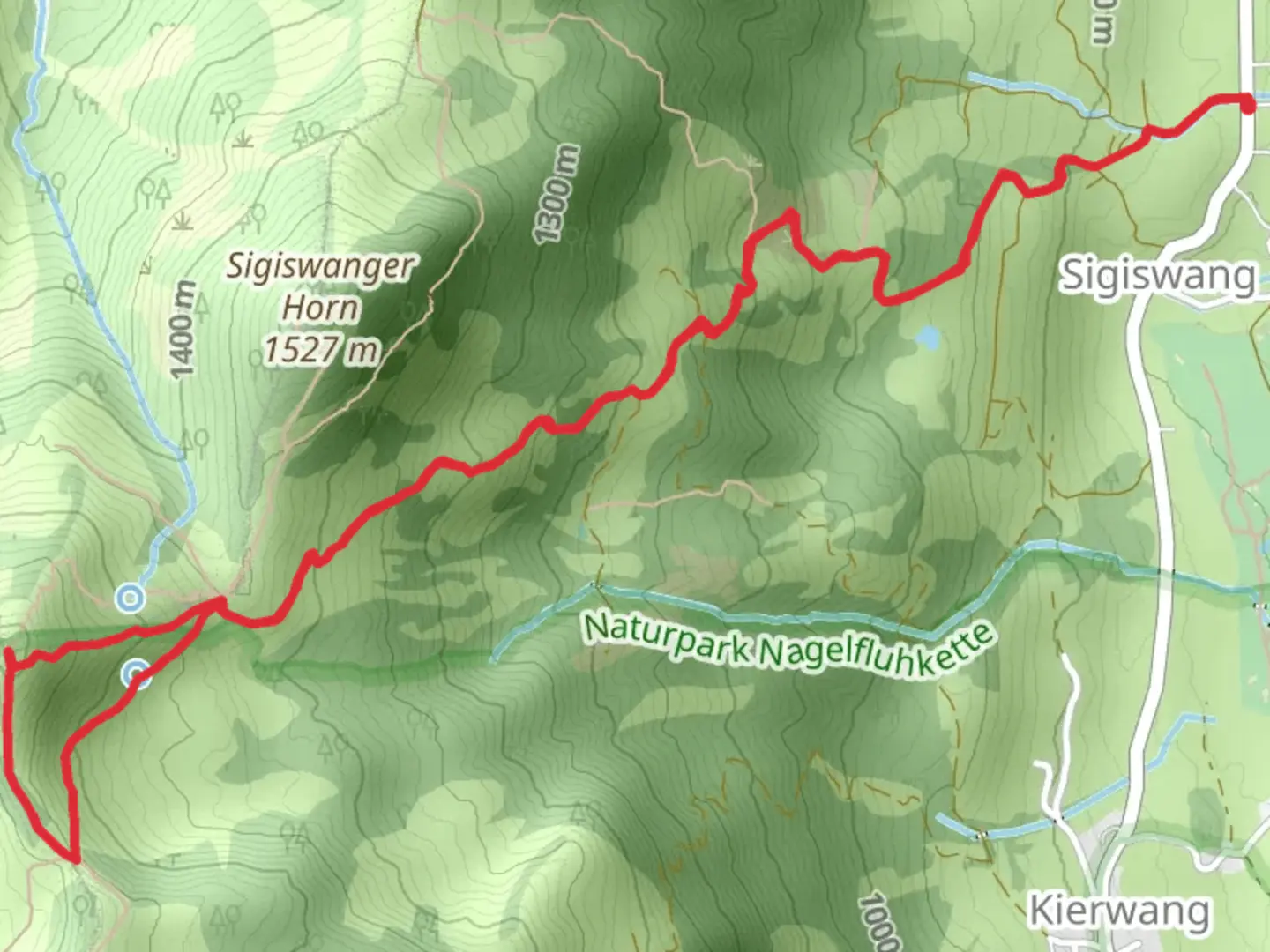
8.2 km
~2 hrs 54 min
768 m
Loop
“The Rangiswanger Horn trail challenges seasoned hikers with stunning alpine views and rich cultural history.”
Nestled in the picturesque Oberallgäu region of Germany, the Rangiswanger Horn Out and Back trail offers an exhilarating adventure for seasoned hikers. This challenging loop spans approximately 8 kilometers (about 5 miles) with a significant elevation gain of around 700 meters (approximately 2,300 feet), making it an extra difficult trek that demands preparation and stamina.### Getting ThereTo reach the trailhead, travelers can opt for public transport or drive. If you're using public transport, the nearest major town is Sonthofen, which is well-connected by train. From Sonthofen, local buses can take you closer to the trailhead near the village of Bolsterlang. For those driving, Bolsterlang is accessible via the A7 motorway, followed by a scenic drive through the Bavarian countryside. Parking is available near the trailhead, but it's advisable to arrive early, especially during peak hiking seasons.### Trail OverviewThe journey begins near Bolsterlang, where the trailhead is marked by a small parking area. As you set off, the path quickly ascends through lush alpine meadows, offering breathtaking views of the surrounding Allgäu Alps. The initial section is steep, so pace yourself and take breaks as needed. The trail is well-marked, but using a navigation tool like HiiKER is recommended to ensure you stay on track.### Flora and FaunaAs you climb, you'll be immersed in a rich tapestry of flora and fauna. The lower sections of the trail are adorned with vibrant wildflowers in the spring and summer months, while the higher elevations are home to hardy alpine plants. Keep an eye out for local wildlife, including chamois and marmots, which are often spotted along the rocky outcrops.### Significant LandmarksApproximately halfway through the ascent, you'll encounter a charming mountain hut, the Rangiswanger Alpe. This traditional alpine hut offers a perfect spot to rest and enjoy a packed lunch while soaking in panoramic views of the valley below. Continuing upward, the trail becomes more rugged and demanding, with rocky sections that require careful footing.### Summit ExperienceReaching the summit of Rangiswanger Horn is a rewarding experience. At an elevation of 1,616 meters (5,302 feet), the peak provides sweeping vistas of the Allgäu Alps and beyond. On clear days, you can see as far as the distant peaks of the Austrian Alps. Take a moment to savor the achievement and capture the stunning landscape with your camera.### Historical SignificanceThe Oberallgäu region is steeped in history, with its roots tracing back to ancient times. The area was once a significant trade route, and remnants of old paths and settlements can still be found. The cultural heritage of the Allgäu is reflected in the traditional architecture and customs of the local villages, offering a glimpse into the region's rich past.### DescentThe descent follows the same path, requiring careful navigation down the steep sections. Trekking poles can be particularly helpful in maintaining balance and reducing strain on the knees. As you make your way back to the trailhead, take the opportunity to reflect on the natural beauty and historical significance of this remarkable region.Hiking the Rangiswanger Horn Out and Back trail is a demanding yet immensely rewarding experience, offering a blend of natural splendor and cultural heritage that is sure to leave a lasting impression.

What to expect?
Activity types
Comments and Reviews
User comments, reviews and discussions about the Rangiswanger Horn Out and Back, Germany.
average rating out of 5
0 rating(s)