Download
Preview
Add to list
More
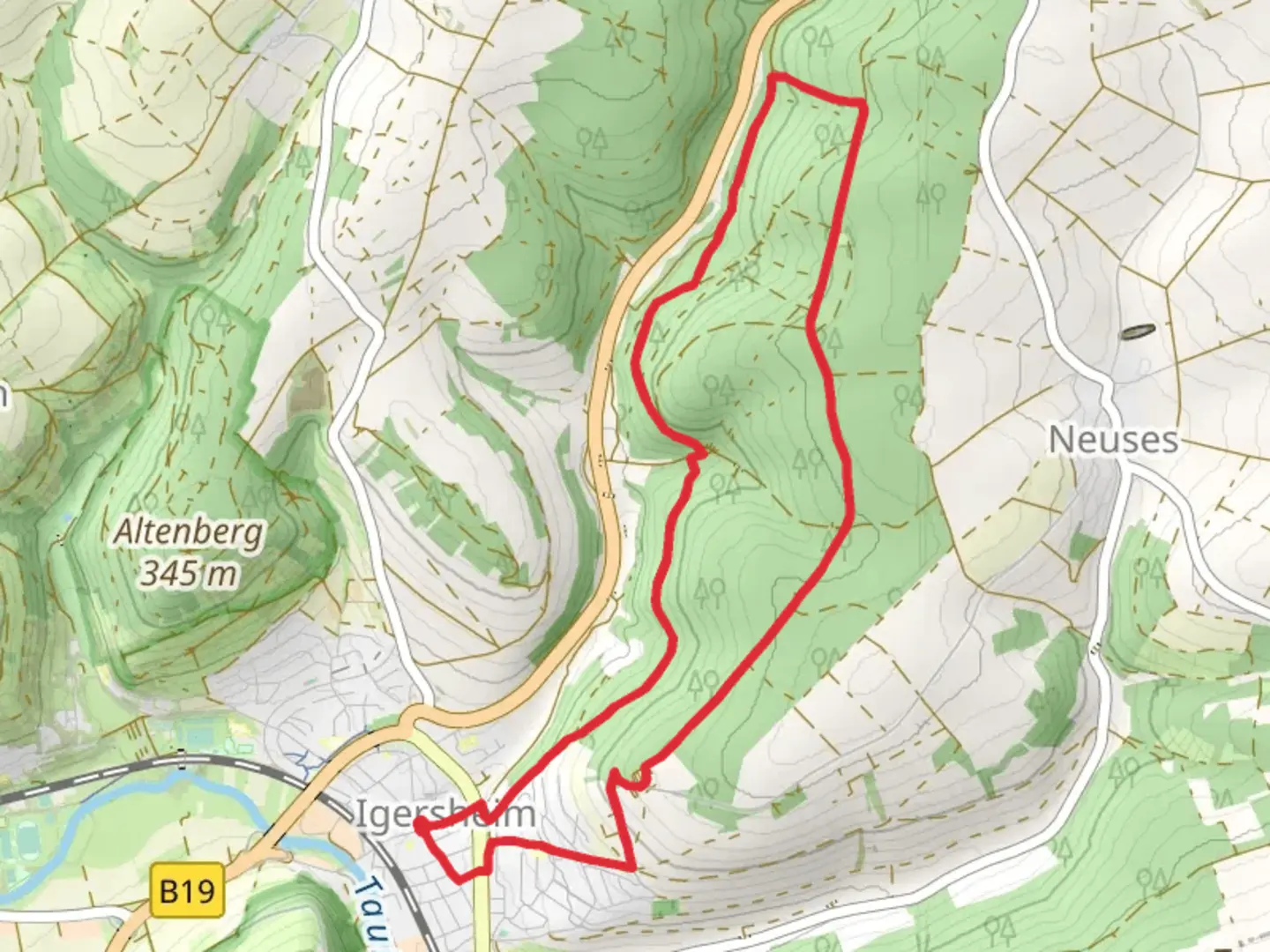
9.2 km
~2 hrs 14 min
236 m
Loop
“The Rundwanderweg Igersheim offers a 9 km scenic loop with historical sites and diverse landscapes.”
Starting near Main-Tauber-Kreis, Germany, the Rundwanderweg Igersheim is a delightful loop trail that spans approximately 9 km (5.6 miles) with an elevation gain of around 200 meters (656 feet). This medium-difficulty trail offers a mix of natural beauty, historical landmarks, and a touch of local culture, making it a rewarding experience for hikers of various skill levels.
Getting There To reach the trailhead, you can either drive or use public transport. If you're driving, set your GPS to Igersheim, a small town in the Main-Tauber district. There are parking facilities available near the trailhead. For those using public transport, take a train to Igersheim station, which is well-connected to major cities in the region. From the station, it's a short walk to the starting point of the trail.
Trail Navigation For navigation, it's highly recommended to use the HiiKER app, which provides detailed maps and real-time updates to ensure you stay on track.
Trail Highlights
#### Nature and Scenery The trail meanders through a variety of landscapes, including dense forests, open meadows, and rolling hills. As you ascend, you'll be treated to panoramic views of the Tauber Valley, especially stunning during sunrise or sunset. The diverse flora includes oak, beech, and pine trees, while the meadows are often dotted with wildflowers, particularly in the spring and summer months.
#### Wildlife Keep an eye out for local wildlife such as deer, foxes, and a variety of bird species. Early morning or late afternoon hikes increase your chances of spotting these animals in their natural habitat.
#### Historical Landmarks One of the significant landmarks along the trail is the Igersheim Castle ruins, located approximately 4 km (2.5 miles) into the hike. The castle dates back to the medieval period and offers a glimpse into the region's rich history. Another notable site is the St. Michael's Church, situated near the trailhead. This church, with its Gothic architecture, is a must-visit for history enthusiasts.
Trail Sections
#### Initial Ascent The first 2 km (1.2 miles) involve a gradual ascent through a forested area. The trail is well-marked, but the incline can be challenging for beginners. The elevation gain in this section is about 100 meters (328 feet).
#### Mid-Trail Meadows The next 3 km (1.9 miles) take you through open meadows. This section is relatively flat and offers a chance to catch your breath while enjoying the scenic views. It's also a great spot for a picnic.
#### Final Descent The last 4 km (2.5 miles) involve a descent back towards Igersheim. This section is a mix of forest and open areas, with a few steep sections that require careful footing. The total elevation loss is around 100 meters (328 feet).
Practical Tips - Wear sturdy hiking boots, as the trail can be uneven in places. - Carry enough water and snacks, especially if you plan to take breaks along the way. - Check the weather forecast before you go; the trail can be slippery after rain. - Use the HiiKER app for navigation to ensure you stay on the correct path.
This trail offers a perfect blend of natural beauty, historical intrigue, and moderate physical challenge, making it an excellent choice for a day hike.

Comments and Reviews
User comments, reviews and discussions about the Rundwanderweg Igersheim, Germany.
average rating out of 5
0 rating(s)