Download
Preview
Add to list
More
7.9 km
~1 hrs 58 min
237 m
Loop
“The Galgenberg Weg offers a historically rich, moderately challenging hike with stunning Rhine Valley views and diverse wildlife.”
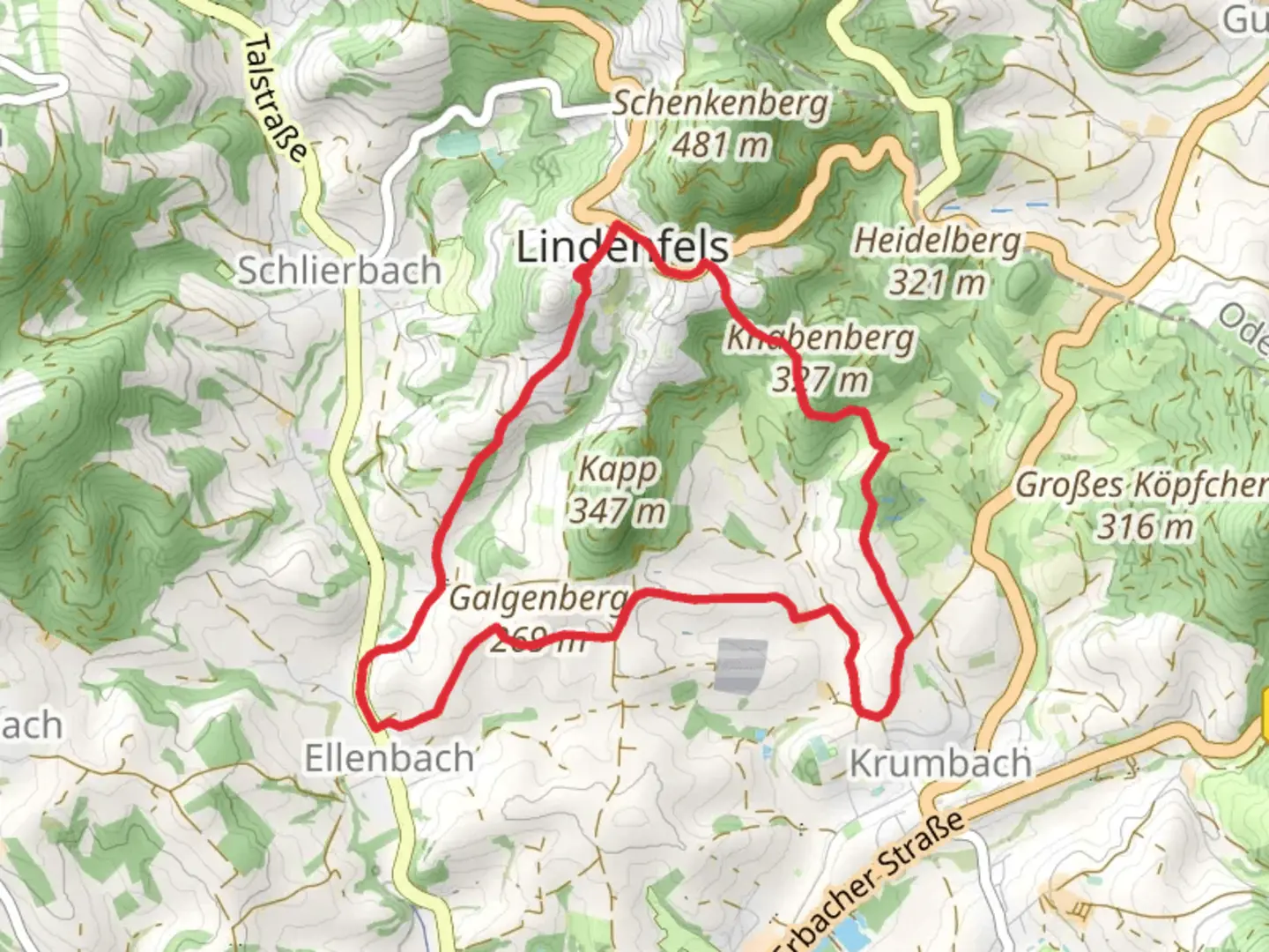
Starting near Kreis Bergstraße in Germany, this 8 km (approximately 5 miles) loop trail offers a moderate challenge with an elevation gain of around 200 meters (656 feet). The trailhead is easily accessible by car, with parking available nearby. For those using public transport, the nearest significant landmark is the Heppenheim (Bergstr) train station, from which local buses or a short taxi ride can take you to the trailhead.Trail OverviewThe Galgenberg Weg begins with a gentle ascent through mixed forests, providing a serene start to your hike. The initial 2 km (1.2 miles) are relatively easy, allowing you to acclimate to the surroundings. As you progress, the trail becomes steeper, leading you to the first significant viewpoint at around the 3 km (1.8 miles) mark. Here, you can take a moment to enjoy panoramic views of the Rhine Valley and the Odenwald hills.Historical SignificanceOne of the highlights of this trail is its historical significance. The name "Galgenberg" translates to "Gallows Hill," a reference to its past use as a site for public executions during the medieval period. As you hike, you'll come across an old stone marker that signifies the location of the former gallows. This somber reminder of history adds a unique dimension to your hike, making it more than just a walk through nature.Flora and FaunaThe trail is rich in biodiversity. In the spring and summer months, the forest floor is carpeted with wildflowers, including bluebells and anemones. Birdwatchers will be delighted by the variety of species that inhabit the area, such as woodpeckers, nuthatches, and occasionally, the elusive black stork. Keep an eye out for deer and wild boar, which are commonly sighted in the early mornings or late afternoons.Navigation and WaypointsNavigating the Galgenberg Weg is straightforward, thanks to well-marked signs and trail markers. However, for added security, it's advisable to use the HiiKER app, which provides detailed maps and real-time GPS tracking. Key waypoints include the aforementioned viewpoint at 3 km (1.8 miles) and a charming wooden bridge crossing a small stream at around the 5 km (3.1 miles) mark. This bridge is an excellent spot for a short break, offering a picturesque setting for photos.Final StretchThe last 2 km (1.2 miles) of the trail are a gentle descent back to the trailhead. This section takes you through open meadows, where you can enjoy the sight of grazing sheep and the distant outline of the Bergstraße vineyards. The trail loops back to its starting point, completing a rewarding and varied hike.Whether you're a history buff, a nature enthusiast, or simply looking for a moderate hike with beautiful scenery, the Galgenberg Weg offers something for everyone.

Comments and Reviews
User comments, reviews and discussions about the Galgenberg Weg, Germany.
average rating out of 5
0 rating(s)